Showing posts with label Kigluaiks. Show all posts

Friday, February 12, 2016

East Fork Solomon Crags


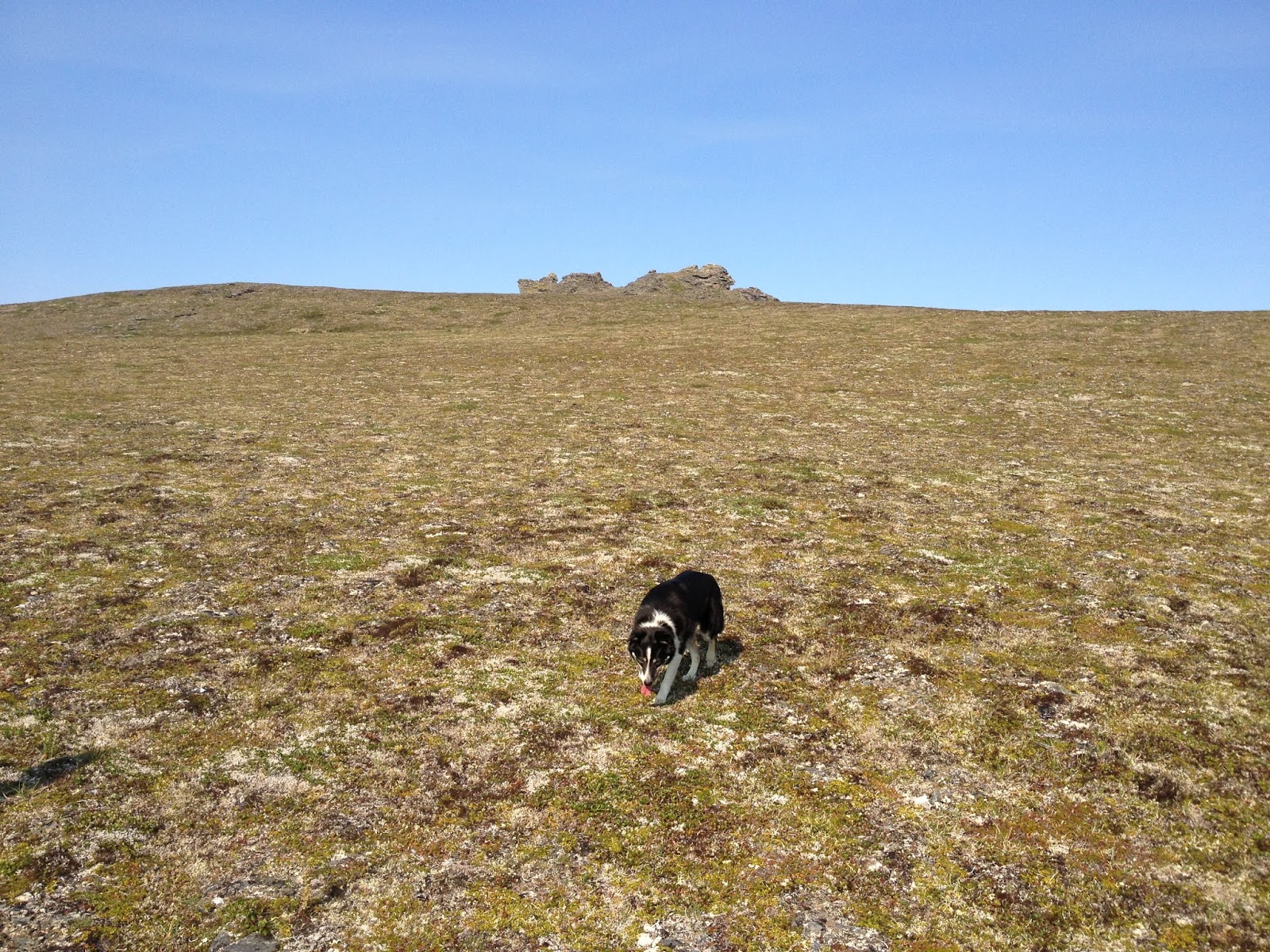
Click on this because maybe it looked like something?  You were mistaken. As the helmetless Mr. Panepinto demonstrates, the East Fork Solomon Crags amounts to nothing more than a mossy turdpile. You succumbed to "Tale of Topographic Oceans Syndrome." 

Tales of Topographic Oceans Syndrome (TOTOS): the tendency of a low-quality rock outcrop to gain in value due to its isolation from other rock outcrops.
Birmham, Lands End, Treen, Avebury, Stonehenge... the album cover for the Vedic concept album "Tales of Topographic Oceans."
     Is this a type of "Prominence" criteria for boulders and crags, similar to the one developed for big mountains? If it were, the crags at East Fork of Solomon River would score well because of the way they stand so starkly alone on the tundra landscape, the irony being that if you hike a few hundred feet up the hill and get right up close to these crap rocks, they turn out to be composed of the utter, utmost, shittily-schistleton choss that the Seward Peninsula can dish up.
James underneath, and dangling from, trigger-happy tons of schist. Arctic Crankloon, 5.4d.
       2015 saw two, good old-fashioned exploratory trips to the East Fork Solomon crags, easily visible from the Teller Road all my years, but never visited. After a long period of climbing at the same old crags around Nome over and over again, it sure felt nice to experience the familiar pattern of sensations that come with first visit to a new clump of rocks:  the uncertainty of where to park (in the case of East Fork Solomon, a gravel pullout right down by the river), followed by the hike up to what hopefully will be a cornucopia of climbing, as the rocks gradually unfold upon approaching them and open up like russian dolls to become more than what they appeared from the road. 
       Or, as in the case of the East Fork Solomon crags, less than what they appeared. TOTOS ("Tales of Topographic Oceans Syndrome") had created a mirage.  These mystery crags had appeared like something off a Roger Dean-inspired album cover of an eighties progressive rock band, but the reality up close was a bad glue job of fragmented schist chunks and turf. 
     
A living, breathing chimney amidst the schist
       First trip with David, we took no ropes. The month was June, Solstice time, the air heavy with flowers, the warm wind making us lazy. The only stone we found worth returning for was the Crankloon, the largest clump of E-Coli-shaped fecal matter among several dollops of fecal matter scattered on the ridge, metamorphic, the whole pile. The Crankloon boulder sported a 23-foot south wall with an actual crack (that precious commodity of schist climbing) that I could almost solo, but chickened, so decided to come back some other time with a rope. 
Crankloon
       Second trip with James, we carted a sack full of paraphernalia up the short hill to the crag. On the way up, James probably imagined we had penetrated to a fantasy climbing area from his wildest arctic dreams, where surreal spires rose improbably from green hills by a twinkling sea.  A fantasy area is what the East Fork Solomon Crags appears to be, at first. But James had succumbed once again to "Tales of Topographic Oceans Syndrome," and only raw choss awaited him. 
       The climb was so short and rotten, I felt rather foolish having driven all the way from town for it, and as the ropes and cams and pins poured out of our rucksacks, enough gear to do a small wall, I felt more foolish still.
      Just to lead the crack, I chickened. So we top-roped, and played around, and James added variations up to 5.4d on the schist that seemed to dripping down at a geological rate like a slow fungus.   
Crankloon
       Let us assign x number of negative points to East Fork Solomon Crags for scabrous choss factor. Fair enough. But one descriptor left out of far in this assessment is beauty— the sad, ridiculous beauty of the spot, the stark, lone, level tundra thrown into relief by tors sticking up invitingly on the horizon, the blue lens of ocean on the other horizon, and moat beauteous of all, the invisible SINH TALA energy of the earth streaming up through the crust so copiously you can hear the white-noise sound of it if the wind is down. So, let us assign y number of positive points for the beauty of the East Fork Solomon Crags.
       Here's the thing:  x <  y   This is the very enzyme action of T.O.T.O. Syndrome itself, turning a crap crag into gold through the rendering process of beauty.  Were the East Fork Solomon Crags located in California they would be nothing, figuratively and literally. As distinct rock entities, they would not garner enough perception from climbers to carry any psychic weight. California has such an abundance of rock, the Solomon Crankloon would not stand out as worthy of notice in any way. In California, they'd probably just bulldoze a piece of schist like the Crankloon out of the way...
        But here on the coast of the Norton Sound, tucked into the subsistence, gold, and reindeer country between Council and Nome, the East Fork Solomon Crags are a gold medal finalist of a Beringian rock garden. James is probably telling his friends about the killer bouldering he did at the fantasy climbing area in Alaska. I am spraying to my friends about my 5.5b "proj", confident they are paying no attention to what I am saying.  The abundant flows of SINH TALA earth energy in the region, combined with an absence of psychic interference from any appreciable human population in the surrounding area, plus the harmonizing influence of massive beauty, amplify the psychic power of the stone arrangement into a sum that is greater than its choss.

Stand on hills of long forgotten yesterdays
Pass amongst your memories told returning ways
As certain as we walk today
Press over moments leaving you
Out in the city running free
Days pass as seconds turn the key
The strength of the moment lies with you
Out tender outward lights of you
Shine over mountains make the view
The strength of you seeing lies with you

Yes
Lucy at Solomon

        Franklin Johnson, engineer, stampeder, grunt, late of the Alaskan goldfields at Nome and Council, former graduate of the Dresden Polytechnikum, and contemporary of Perry Smith and Fehrmann on the sandstone climbs of the Elba River banks, tried to spit, but his mouth was too dry. 
       Dry. One plaintive thought in Johnson's mind.  There'll be water at East Fork. Then: Sure gotta hate sledging a load in the summertime. But there was nothing else for it. He had to get this axle over to Big Hurrah, and pronto, too, and there sure as hell wasn't no diggety train gonna haul the thing over. So man haul it was. 
       At the East Fork of the Solomon River he drank his fill, then had a little snooze in the sun, though the breeze dropped at the end and the bugs woke him up. A little venison, and then... 
       Johnson noticed the rock outcrop a short ways up the hill.  His known eccentricity of climbing the rocks held no witness this time, other than a family of bears and two foxes.  Johnson ambled up to the hill for some klettern on what he hoped would be some good stone. 
      But when he got up to the rocks, Johnson took one look and, without even bothering to mount a hold, spat on them, successfully this time. The rock was of a kind that Fehrmann would have blurted, "Scheiss!" Johnson had an appointment with a 100 lb. sledge down and seven more miles of muddy road. He made a mental note of the crags and started down the hill.

Sunday, September 7, 2014

Peak 3250+ (SaGuiq), west ridge attempt

       Theme: people snowboarding down things I call climbs. The latest humiliating installation comes via this awesome video (below) of Miner Joe and another guy boarding the west side of Peak 3250+ near Mosquito Pass, shot from a Bering Air helicopter in 2012. From my personal viewpoint of everyday flow, I experienced this video as a synchronicity factor 1.2, a slight rise in the standard deviation of normal coincidence, as the following tale will tell.


       Eighteen Saturdays ago, ( the current rate of blog-lag), during the climate-change brief window of optimal snow conditions we experienced last April, I loaded the Bearcat, nicknamed Super Smooth Andy G., onto the trailer and slush-bogged it to the place at Mile 30 Kougarak Road where all the trucks and snow-machine trailers were parked, just before Nugget Pass where the plow hadn't gotten yet.
(above) Kougarak Road heading north to the Kigluaiit.

        The terror of driving the truck and flagellating trailer up the mud road, the horror of gunning the throttle to load  big, scary Andy G. on and off,  the loathing of this mechanically-inept, environmentalist hippy at the smoke-belching engine, followed by the hypocritical utter joy of whizzing off on Smooth Andy G. into the Kigs at incredibly high speeds, west over good Spring crust.

(above) Snow-machine mountaineering journey to Peak 3250+, April 19, 2014. Kougarak Road was open to that point.

           Snow-machine crept a thin strip between the Windy Lakes and the foot of the mountain, didn't want to go out in the middle of the lake on that big piece of metal, too much thought of the temperature weirdness that winter— Nome had been a Zambonied ice rink, its snow-plows sleeping, a winter with two or three different times of rain. I imagined parabolic thaw fields lurking in the ice cover of Windy Lakes, and hugged the shore, up against the many rocks showing through.

(above) "Never get out of the boat!" Looking northeast up the Sinuk headwaters, April 22, 2014. This was a trip to the same peak several days later, again unsuccessful when Super Smooth Andy G. could no longer cross the Sinuk, which was breaking up for miles in both directions.

    Parked Super Smooth at the foot of west ridge of Peak 3250+. This mountain is an old friend, a lump of quartzose schists jammed up against the neighboring gneiss of Tigaraha to the north, not quite sentient, but with enough presence to be referred to as an entity. The best camping spot in the Kigs, the "hundred-year old rock slide" sits at the base of Peak 3250+ to the west. On a long summer day in 2002, Kristine and I climbed the southwest ridge, a horrible, festering Class 4 choss mound. I went back on snow-machine to bag the next ridge to the left  (west ridge) on a school Sunday years ago, but was defeated by a large NAP that swept over me in the warm afternoon sun. But I had come back for another try, and the temperatures were too cool this time for napping.

(above) Saguiq from the south. Southwest ridge is left skyline.

       After many trips, a mountain begins to require a name. Other things require names as well: clumps of willow, glacial erratics, indistinct bluffs, tundra dips, morainal confluences, pee spots, hills— all those features hitherto without a name that now do require a name, just so you can use them as milestones to get through long torturous hikes into the Kigs under a 60 lb. climbing pack. But a mountain, especially, requires a name.
       Hiking in to Mosquito Pass from the Kougarak Road, the hiker crosses Buffalo Creek, then Hudson Pass, then Sinuk, and Northstar Creeks. Reaching Peak 3250+ in the Windy Creek drainage means the hiker has "turned the corner" on the hike and finally arrived. Thus, I have always thought of Peak 3250+ as "Turncorner Mountain," which, under the "First Languages Fairness Compensation Act" must necessarily be translated into Inupiaq, a translation which in this case has been taken care of by my new contacts in the Qaweraq dialect department at the school in which I work. The result is the word "SaGuiq" (sah-ghoo-ik) to refer to Peak 3250+, which means (kind of, sort of, maybe) "turn the corner" in Qaweraq, the dialect of the southern Seward Peninsula. The capital G designates an Inupiaq "dotted g,"  the consonant pronounced with a glottal growl. Henceforth, I will refer to Peak 3250+ as SaGuiq, even though the governing body which has made this appointment is nothing more than large and random agencies of neurons in my scattered head.
(above) SaGuiq from west, west ridge on left and southwest ridge on right. In between, the face boarded in the video.

         This post chronicles a climb far from rad. In summer, the west ridge of SaGuiq is probably Class 3, and as we saw in the video, is perfectly skiable in the spring. 
      Nevertheless, I bailed.  The issue this time was not a NAP descending from nowhere, but moderate avalanche conditions up near the top. It was the wind-loading problem: snow piles up in the deposition zone on the lee side of a ridgecrest. The slope had already whumpfed twice under me on the way up;  now the snowpack dynamics were changing once more within the little narrow band of weather tucked under the very top of the mountain. 
       My route traversed over to some rocks, but I began to visualize how the pad of snow supporting me would disintegrate under my weight;  my crampons would snag, my tib-fibs snap, my body tumble in a slither of snow.  MOJO power-leaked from my energy body.  Suddenly, the alternative of going down seemed perfectly acceptable
(above) Looking south across the southwest ridge from the west ridge of SaGuiq, April 19, 2014.

        Retreating due to avalanche danger creates a Schrodinger's cat of a paradox: if you had continued up the slope it would have avalanched, but since you didn't, it was never going to.  And you never get to find out the answer until the cat climbs up the slope, which if it doesn't, you never do. All in all, a situation designed to torment a self-negationist such as me. As I rode back towards the road on Super Smooth Andy G., my mind was busy performing obstreperous rationalizations. 
        I made the decision to invoke the LIVE TO SEE ANOTHER DAY CLAUSE (a rule of the mental game which basically states that the climber cannot be punished or battered by self-judgment in the case of ambiguous bails) and tried to convince myself that the slab conditions on the climb I was bailing from had fallen in the "fifty-fifty" category— it might've gone, it might've not— but my claim seemed false. My attorneys tried to throw together a defense based on me being solo—  "...if I had a partner I would have scampered right up it, you can't take any chances when you're solo in the Kigs..."— until it was pointed out the nullity of this argument in the precedent of allapa vs. Swan Slab Jamcrack (1981), given that the climb itself is exactly the same whether you are solo or with a partner. Most damningly for my case, Intuition was prepared to testify that the slope on Saguiq was fine. Eventually, a straight CHICKEN-OUT was handed to me. I took it home and logged it on the shelf with all the other CHICKEN-OUTS. 
(above) On the right, Kirgavik Inuatqi (Killer Falcon Peak), Pk 3000+, between SaGuiq and Tigaraha. Had a fine day on good rock in the summer of 2002 soloing those little, (60-80 ft.) dark, gneiss tors in the picture. A falcon tried to murder me near the summit, hence, my little pet name for the thing. Osborn in the distance...

         Retribution for a chicken out.  Back in school the following week, I was visiting a colleague in the second grade pod.
       "Dude," he called from his teacher desk. "You know where this is?" He flipped his laptop around and showed me the same youtube that started this post.
       I was flabbergasted... the Kigs!  On youtube!  We recognized miner Joe and the Bering Air helicopter pilot. But I couldn't identify the mountain. So we played the video several more times. My face grew closer to the computer screen. Planes of snow spun around in circles, cliff patterns riffled through like shadows, familiar landmarks swooped by, and I grew nauseous with motion sickness. Finally, the fragments in the Kigs-o-scope coalesced into a specific place. I recognized the place. 
       The scarlet "L" began to burn like fire across my forehead. These yahoos were boarding down the same mountain I had bailed off the previous weekend! 
(above) Peak 3250+ at far left edge of photo, looking southwest. This gives us an idea of the peak in relation to its friends. Moving right one sees the dark mass of Tigaraha, with its 800 ft. north wall.


"It doesn’t matter how much effort it takes. The consequences of an accident are so huge, I think, in retrospect, and it's easy to see things in retrospect, what should we have done?  We should have had visibility. and should have waited, but it would have been a hard one to sell to us at the time...

"Avalanche danger is always high, and sometimes it’s really, really high, but that’s the attitude of walking on thin ice and really being highly aware all the time of the hazard so that you’re doing this right. All of a sudden you stop and say, hey wait a minute, is this going to be OK? Can I pick a better route, or can I get on belay and get out on the slope and dig a hole in it and see if I can reveal some layers and assess some stability, but really taking that avalanche hazard very seriously…

"I don’t hold anything against the mountains. I’d say that i’m hugely more… PARTICULAR about the things that I climb, and I’m just very PICKY.  I just won’t get on anything anymore…. in college, I was, we all were, just a little bit more ready to jump on everything..."

Thanks to Colby for the quotations, and the esteemed Dr. Krupa for listening. 


(above) Tom Walter, my great mentor from the eighties, sucked down by wind-loading. He would stubai his way up anything.

       After I trundled out Tom in Kigscourt, I was acquitted, lock, stock, and barrel. There was not a pin to be dropped after Colby's testimony. I was handed the LIVE TO SEE ANOTHER DAY CLAUSE that I had originally requested. I was even given a pass on self-humiliation over the snow-boarding video; it was remembered that around the time those boys were skiing SaGuiq in 2012, Tyler and I were over by PiNarut (Pk. 3367) (ping-a-root) throwing glory turns in tight couloirs. Sometimes the snow is O.K. And besides, these are all absurd turns of mind and deserve to be ignored. The truth remains that when traveling solo on snow-machine and climbing mountains in the Kigluaik, you want to avoid any kind of screw-up. /k/ /k/ /k/


(above) One of our Kigsblog photography staff, none too enthused with the skiing conditions at Nugget Pass around the time of this adventure, April 2014.