Answer: I'M HAVING SO MUCH FUN DOING IT. There is something about the Internet, with all that consciousness pulsating through each keystroke, that is blowing away my lifelong writer's block. Every unit of suppressed spray accumulated over years is coming bursting out, accompanied by features formerly poo-pooed, such as maps, pictures, and route descriptions of climbs which are not even climbs at all, but firmly belong in the category of hikes, such as today's feature. Blame it on the utter transparency of the Matrix. Couple this giddy loss of cyber-inhibition with the giddy fun of hiking and climbing in the Kigluaiks, and click!, you have these transgressions. I invoke the Alex Lowe theorem: FUN is the measure of the climber.
"...Go out and have entirely too much fun..." Doug Buchanan


(above) inuksugait Strange to be surrounded by homunculi in the lonely mountains. Here is a link about rock piles that took seconds to find:
...and so there ain't nothing more to write about, and I am rotten glad of it, because if I'd a knowed what a trouble it was to make a book I wouldn't a tackled it, and I ain't a-going to no more

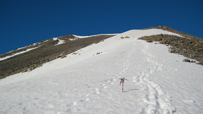
(above) Pk. 3000+, one of the high points on the divide running west from Glacial Lake. Class II. It was a hike-up. I got a funny feeling it has been ascended before. My first foray of the summer into the high Kigluaiks, the well-springs of power, chi, prana, sinh tala in Athabaskan.

(above) The ridge took about an hour. "The best climber in the world is the one having the most fun." It was so much fun last week to simply be hiking up a little mountain, not surfing around my own event horizon on a death-pile.

(above) Looking east around the bend of upper Johnstone Creek canyon. Pk. 3000+ in background.
MY EXCUSE for LAMENESS, for not seeking out a pocket of true, TECHnical climbing: this was an exploratory trip.
Never had I properly explored the western side of the Kigs, it was time to do so. The goal was to find a southern approach into the Kigs from the Teller Road into Canyon Creek, where lurks granite. The GLUE of town was attached to my ass like a stretchy tendril, so I couldn't stay in there long enough—3 days, 2 nights— to do justice to my explorations. The resistance of the GLUE was greatly increased by my extreme and irrational BEARONOIA, though once I got out there with my cannon slung over shoulder and madly singing, I saw literally no critters at all the entire three days.
So, what follows, simply because it's so much fun, is a little panoramic indulgence. To a true Kigs enthusiast it would prove irresistable and might help mediate the disgust you should feel at this public disrobement of beauty. It should also remind you somewhat of a dog trotting in circles peeing in various places systematically and with great enthusiasm. Do dogs not have fun when they do this? And is not FUN the justification for today?
Thanks to "Bedrock Geologic Map of the Kigluaik Mountains," by Jeff Amato and Elizabeth Miller. I am butchering the geology.

(above) View looking east from summit of Pk. 3000+.
1. Tigaraha. Means "finger" in Inupiaq. I've climbed it by at least 3 different routes, with Mikey and Lahka, but don't know who made the first ascent. Gneiss.
2. Pk. 3367. Visible from many places. A landmark. Cobblestone headwaters. Deserves a name. I've always called it "Three Gables" ("Tikilik" maybe?). Climbed it solo one Iditarod on a mystical snow-machining day. No idea about the first ascent. Schist.
3. One of the Grand Central or Crater Creek peaks. It's probably Fox (Kayuqtuq), poking up from behind. Currently stalking this one. Gneiss and schist clashing zone.
4. [i think] One of the Grand Central peaks that form the right side of Grand Central, Pk. 3190. I always call it the "Mother." ("Aana"). Snow-climbed it one spring via machine. Schist, as are the next two.
5. A little Grand Central peak, 3290 [i think]. I always call it "the Child" ("Uiviilaq"). Skiied with Tyler and Keith one year.
6. Tallest Grand Central Peak besides Osborn, Pk. 3922. The "Father" ("Aapa"). Cramponed up with Phil on a very cold January day.
7. Mt. Osborn, Pk. 4714, King of the Kigs. First ascent unknown, at least to me. Do not leave comments reminding that it does not matter, we know this. Maybe it was Osborn first climbed Osborn? Probably a hunter from Beringia. It's only a rolling, flowing lump in the mantle. My understanding is that Osborn is a giant chunk of "meta-sedimentary" marble riding up on the pluton.

(above) Looking northeast from Peak 3000+.
7. Osborn, with [probably] unclimbed west face.
8. Pk. 2490. Just north from Glacial Lake on the right.
9. Pk. 3320. I mean the peak down below the little red "9".
10. The north peaks of Osborn. (one on right higher.)
11. Suluun, the Dorsal Fin. Andy and I did 3 routes there. 8, 9, and 11 are a line of the orthogneiss, pink on Jeff's map.
12. East terminus of a line of jagged peaks visible from Teller. Are they the "Sawtooths"?

(above) Looking northwest from Pk. 3000+
12. I've heard them called the "Dragontooths" and the "Oro Grande". "Sawtooths" works. Ascents by Amato. A ridge studded with granite tors.
13. Pk. 3700+ over by Falls Creek. I would like to know more about this area.
14. Pk. 3300+. Granite. I suspect it of having non-hideous rock climbing.
15. The mysterious 3850+. One of the higher elevations in the range.
16. Canyon Creek. MUCH more searching for real climbing to be done.
O, my offense is rank, it smells to heaven...
It hath the primal eldest curse upon't—
And yet, here's one more. A sign of aging, plus extreme self-centeredness, plus lack of job.

(above) TR region, Johnstone Creek area
1. Pk. 3000+
2. Inuksuk pass (see below)
3. "Johnstone/Right Fork Pass" I had good walking on snow fields, probably a doable snow-machine ride in winter if there were not cornices..."
4. Pk. 2930 a slice o' the gneiss
5. Pk. 2710 couple of hour backpacker's climb, I didn't get to it.
6. Another way to get over to Canyon Creek. I'd wager it's machinable.
7. Pk. 2345 I climbed a little 5.7 on the summit tor; this is a classic hike.
8. My bearanoid campsite, out of the way of the main corridor.

(above) inuksugait Strange to be surrounded by homunculi in the lonely mountains. Here is a link about rock piles that took seconds to find:
...and so there ain't nothing more to write about, and I am rotten glad of it, because if I'd a knowed what a trouble it was to make a book I wouldn't a tackled it, and I ain't a-going to no more
No comments:
Post a Comment