Saturday, August 18, 2012

Oro Grande Tors


(above) Peemarking system for Oro Grande peaks.  We climbed at Tors 1, 2, 3, 4, 5, and 12. Following is a recap of one of my most successful rockclimbing trips ever to the Kigluaiks, with Andy Sterns from Fairbanks, July 7—15, 2012.  Russell Rowe flew us in with Bering Air in one of their beautiful red Robinson helicopters—  my praise for this classy local outfit is so boundless, it will require its own post. We hiked out over Mosquito Pass in 2 1/2 days. 
Tor 1:  Pk. 3595, (high point of ridge) climbed on day 1, Mathes Crest (III, 5.9)
Tor 2:  "West Scruffy Tor," East Arete (II, 5.4), climbed on day 5
Tor 3:  "East Scruffy Tor," West Arete (II, 5.7), climbed on day 5
Tor 4:  Stanage Tor Area,  Stanage (II, 5.7) and Eddie Munster Tor (I, 5.7), climbed on day 4
Tor 5:  Pk. 3350+, the "NaulogTor," Caballo Blanco (II, 5.9)***, climbed on day 2
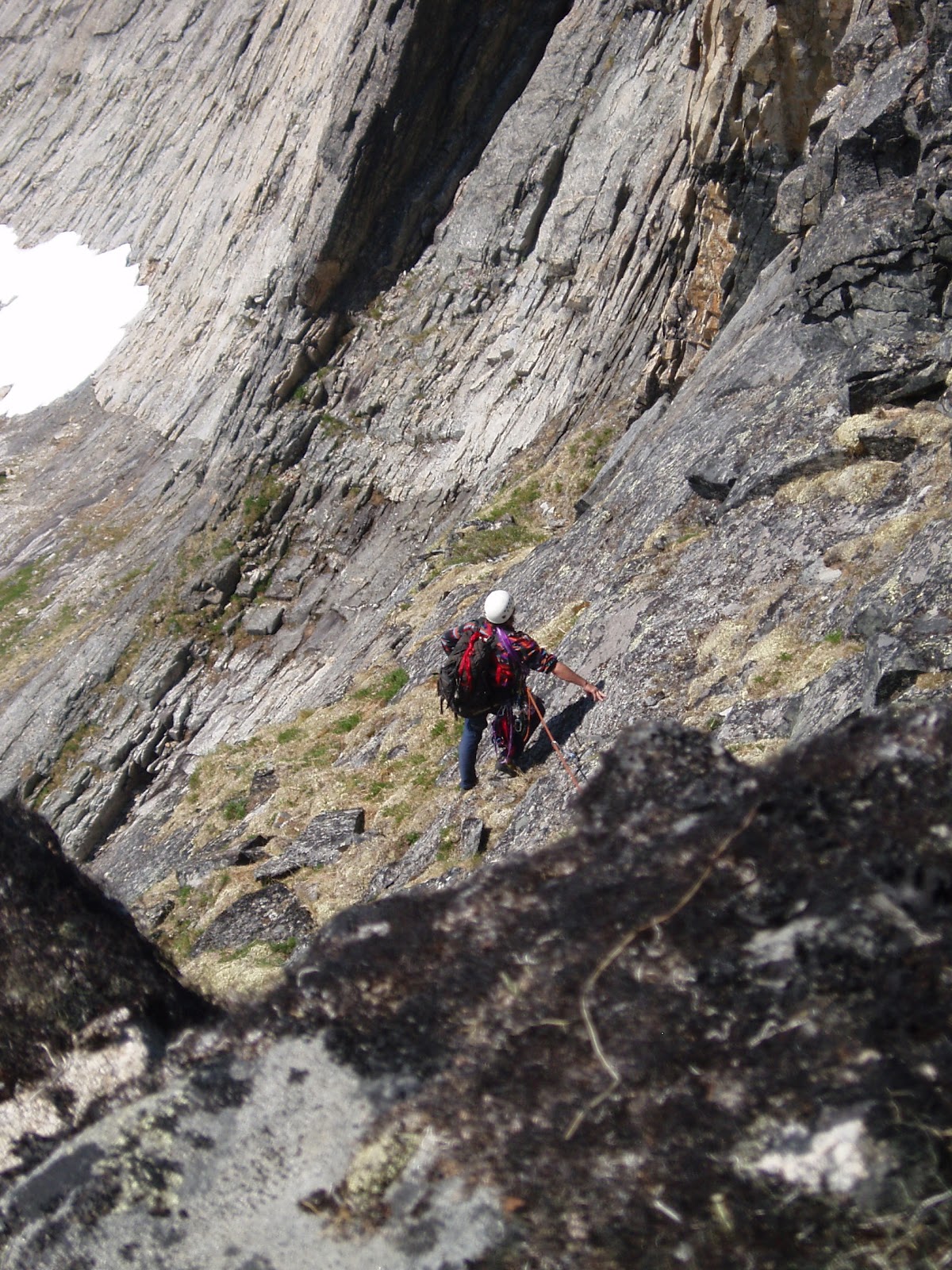
Tor 12:  Pk. 3275(?), West Arete, (II, 5.2), climbed on day 6  
DISCLAIMER for map and images:  These maps suck. The whole thing is silly, a Narcissus Loop against a pool of mountains.  This data is the result of errors and disorientation. Andy and I made up almost all the names of peaks and tors for our own convenience during the trip, and I have kept to those blurts for this article. The pictures were taken with paper cameras.  They are offered here only for the sake of PEE-MARKING.  For Kigsgeeks only.

     Awash in joy, but we didn't know it at the time.  Huge drafts of EARTH ENERGY rose from the Imruk Basin and broke like a wave-cloud over the nearest ridge to the south, which happened to be the sawtoothed ridge upon which Andy Sterns and I were topping out out on the highest tooth, marked as Pk. 3595 on the map, on the first day of a weeklong trip to the Oro Grande drainage, Saturday, July 7, 4SA.  We did not detect this ENERGY with our senses;  we were not aware of the ENERGY at the time.  Any analysis of this ENERGY would necessarily require more time, effort, and intelligence than we had then— or now, for that matter.   The only fact I have relating to this EARTH ENERGY is that Andy and I did indeed extract several lifetimes of  joy from our climbing trip to the Oro Grande in July, 5SA, leading me to believe that the mental and physical health benefits we enjoyed for weeks after the trip must have been due, in part, to the increased doses of EARTH ENERGY we received each day we made the brutal 3000 ft. approach up to the ridgecrest to bag another tor.
(above) NauloqTor, Caballo Blanco, pitch 3.  Tor 5, day 2.  The Nauloq, named for the presumptuous way this white shaft of granite thrusts above brown gneiss buttresses, was the nicest specimen captured in our bag of tors.  The third pitch provided an honest-to-god Yosemite 5.9 pitch (as opposed to the usual Kigs 5.9 rating which is really only 5.7 bumped up for choss factor), complete with some nice offwidth at the top. (below)


(left) 
NauloqTor (Pk. 3350+).  Caballo Blanco follows a crack system towards the righthand edge for two pitches.

(below) A view of the quality first pitch of Caballo Blanco.


  What, exactly, is EARTH ENERGY, one asks, eyes rolling...  But there is a rule that Kigsblog must stick to the climbing.  I had advertised the Oro Grande trip to Andy, who would be required to pay the hefty air miles to get to Nome from Fairbanks, as "a ridge studded with one-pitch tors," but the pleasantly-surprising reality turned out to be that the Oro Grande tors are more like "two to five-pitch" tors, on some very nice pre-Cambrian Orthogneiss that, I am told by expert Geospewers from UAF, might just as well be referred to as "granite".  From the north, this ridge really puts the sawtooths in "Sawtooths";  the Oro Grande tors bear an uncanny resemblance to the tooth pattern on a conventional bowsaw.  While it might seem silly to go to such great lengths of trouble--  planes, helicopters, huge approaches, mounds of gear, over-application of bug dope to skin, all the things required for Kigsaneering-- to climb a few individual teeth barely rising up from a bow-saw, it is also true that each tor presented its own unique climbing challenge, and each tor felt plenty committing as we perched and waggled from tenuous eyries, high above the Seward Peninsula, with the spooky Imruk breathing into our souls like a sleeping dragon.


(left) Andy commencing the "High Exposure" traverse on pitch 3 of Stanage Tor, an inspired 5.6 lead that spiraled around the exposed summit of the tower over rounded, hideo-chossic holds.


(below) Stanage Tor, pitch 1.  


(above) Stanage from west.  There's a fantastic-looking pitch of steep, thin crack around the corner on the south face.  We doubted our ability to free-climb it in acceptable style, and so walked around the corner to climb three fine, shortish pitches on the 200 ft. turd pictured above.  
(above) Stanage from east.  Stanage is the dark pillar lowest in line, so nicknamed because its brown gneiss reminded us of its eponymous sandstone crag in Britain (a place neither Andy or I have ever climbed.)

   The organizing force of NONENTROPIC MENTAL PROCESS was busily at work permeating the very molecules of the mafic minerals on which we climbed.  The land was thinking, and our neuro and physio networks were engaged in a dialogue with the thinking patterns of the land itself.   Living material is far more liable to difference (change) than non-living material; nevertheless, non-living material such as  the cliffs of Pk. 3595 Tor is still subject to NONENTROPIC MENTAL PROCESS, however slightly from our frame of temporal reference, and our neural networks, (speaking for Andy I'm sure!) transformed by the shamanic practice of rigorous climbing in a wilderness setting, were vibrating in resonance with the electromagnetic backdrop of the solid matter in the our localized space/time region. 
      
(left) Ian enjoying the fundalicius 5.7 pitch 2 of "Mathes Crest" (III, 5.9) on "3595 Tor," the highest elevation on the Oro Grande ridge, and our first day's objective.  We managed to get a satisfying 6-pitch climb out of a series of continuous buttresses, essentially the south face and east arete of Pk. 3595.

(above) First two pitches of "Mathes Crest" climb chewed-up books towards  right.

(above) Manky 5.9 overhang on first pitch of "Mathes Crest."  On our first day of climbing I wanted to impress Andy, who had been commendably assuming the lead all through the allapa, freezing-ass days of Winter when the medium was ice and dry tools;  now that we were back on Californian terrain,  pure joy freed me from the chains of doubt and I mantled  onto a dessicated chickenhead.

(below) Looking down on the rest of pitch 1 at Andy following.


(above) Ian topping out on east summit tor of Pk. 3595, pitch 3.  What followed was a pitch of easy, fun, hand traversing and horizontal arete hiking that in our wildest dreams reminded us of the Mathes Crest at Tuolumne.


(above)  Author leading pitch 5.  We were rewarded with this bonus 5.8 wall of stellar overhangs rising out of grassy ledges that led to the true summit of Pk. 3595.  At the high point we found an Army Corps of Engineers "VABM" marker embedded in the summit rock, plus an ancient sledge hammer;  turns out there was a sneaky Class 3 / 4 scrambling route up the north side of the tor!
(right) Pk. 3595 is the peak on the left as viewed from the west on an attempt in April, 2011;  I retreated due to a purple leg, Yukon Jack, and the No Sketch Partner Law.  Not all of these sawtooths are very toothy on their northern sides:  this is a complete reversal of the normal Kigluaik configuration where the north side is the cliffy side and the south side the gentle slope.  Up until the moment Andy and I mantled onto the summit, I was unsure if we had chosen the same peak as the one in this picture.

   It was pooling out in the Imruk Basin, slowly pooling... Thought is influenced by gravitation (postholing in the spring crust has proved) and the consciousness patterns came sinking gradually sinking down like electromagnetic sediment into the vast bowl of brackish  water... Now it was billowing back upwards in great auroral blooms, the breeze freshened over the spires...  and NOW the impulse wave came washing over the tiny figures lashed to the prow of the summit rocks.  One of the figures is dangling, trying to retract a pair of cams;  the other is sitting befuddled with a rope locked tight in his hand, hopelessly trying to figure out the mystery of double-rope technique.  Nothing special appears to be happening.  The weather shines hot and sunny.  Alles ist im Ordnung. The tiny climbers go about their business.
      But this moment is a very pivot of their lives in time/space...  in that moment, lives are exchanged, some die, others pop in...  the contour lines of the climbers' personal power, the fabric of their ongoing creation, suddenly bunch upwards in the shape of a mountain to accommodate the immensity of this moment distorting the causal fabric of their lives, as they stem painfully inside corners between the Volkswagon glue-ins, rolling dice with the people they've left behind.
(left) Andy on summit slab pitch of East ScruffTor, an immaculate 5.2 pitch— for one moment, as golden and casual as Lembert Dome.


(right) Andy crunching symbiote on our second climb of the fourth day, the "East ScruffyTor" via its "West Arete" (two pitches, a bit of 5.7).  Visible in the background is the sunlit base of our first route of the day, the "West ScruffyTor," via its "East Arete" (two pitches, 5.4).  Both of the twin Scruffies were treated as hobnail boot, summit baggy, Sierra Club-style climbs, and offered occasional spasms of good climbing in between inclined fields of vegetated choss, with beauty off the scale.


       Mornings come stiff as a board, then more flexible with breakfast.  By the time we reach the nude sunbathing slabs at the highest water-bottle fill, we can already see just across the way to the mini-Emporer Face of Mt. Osborne, sedimentary King of the Kigs, Pk. 4704.  Maybe it is one of the days we had gear stashed at the top, or maybe we are toting the rack, rope and water all the way up.  The only thing that gets me up that immense approach each day is ONE-FOOT-IN-FRONT-OF-THE-OTHER TECHNIQUE—  the simple technique of just not looking any further ahead than the next step.  Like Dave Johnston wrote of Foraker's Sultana Ridge, "I'm just a slope jumar."
    The reward was always worth it, a nice little tower or two of granite sporting some real Grade A pitches on stone so fine in most places you could sell pieces of it as healing trinkets on Telegraph.  Cams snapped neatly into cracks so falsely-secure you only had to back up and equalize once.  On top of tiny pinnacles we found only the puzzle of the descent, often something we didn't think about until too late, then the strangely macabre game of building the most cheapskate anchor possible.  Stagger back into camp 17 hours later, hallucinating, repeat cycle, awash in joy, bathing in CHI.


(above)  The pitch that got away.  Rain was coming soon and we knew we should stop and climb this nice section of rock in the picture for the fun of it, but we opted instead for summit glory, and scrambled further upwards for the impending West Arete of Pk. 3275, which we figured from the look of the thing from our camp to the south was a committing arcing, 3-pitch knifedge up a Roman helmet of granite.  The reality was another Sierra Club R.C.S. outing, a ridge with a pretty mellow north side, a long line of ladies holding up their dresses.  I could smell previous ascents of this rather prominent summit;  there looked to be nice hiking terrain leading up to the peak from Windy Cove down on the busy marketplace of the Imruk Basin.  A fine outing, but we shoulda climbed this picture. 


(above) An enjoyable section of climbing on the West Arete of Pk. 3275 (II, 5.2).  I must admit to virtually making up this peak elevation due to inadequate map skills;  I think everybody does this in the Kigs, there's a kind of poetry to the two-digit numbers.  Thirty-two, Seventy-five.  Thirty-three, Sixty-seven.  Thirty-eight, seventy.  Two-Six, Two-Six...   


(above) Transitioning to the green, West Arete of Pk. 3275.  This is called a Monty Python shot:  Andy appears to be simulating  climbing on flat ground.  You get this problem a lot in the Kigs with climbing shots taken from the belay.  In fact, Andy's feet are still perched at the top of a steep slab and the grass is slick with rain.  Andy is happy for the rope at that position, though we are just about to shed the rope for a dash to the top before the deluge.

    The pluton at the heart of the Kigs, the swelling gneiss dome itself, the 35 mile slab of meta-igneous rock the gold miners simply called bedrock— insect climbers scuttle on the protruding bone ends sticking from the tops of the 3,000 ft. ridges.
    The minerals that compose this pluton, the molecules in the minerals, the constituents of the nuclei in the molecules, quarks, leptons, tie the missing pieces together with string dimensions inaccessible to the human brain alone, throw in nonentropic, periodic patterns of organization within this quantum soup... 
      You get the whole blob of the Kigs acting like a huge magnet, a lodestone slightly distorting the electromagnetic backdrop of this region of time / space / matter, displacing the normal even flow of time/space ever so slightly.  The mountain interfacing with the quantum foam....
      The electromagnetic energy bodies extending from the creepy-crawly insect climbers (auras) flutter momentarily like haloes in faerie wind.  Andy is saying something but his words are lost on the echoing walls.  My hands are too painful and scabbed to notice the acquisition of CHI in the synaptic spaces where my being interfaces with the quantum foam, my brain is too dulled with fatigue to notice the revitalization of my life force.  Left my Klif bar at the bottom.


(above and right) Scenes from day 4 on Eddie Munster Tor.

     My neuro-transmitters had been mangled that morning slogging up the talus with a pack.  After fifteen hours on the go, both Andy and I had gone past that familiar point where extraneous speech is avoided, we went about our business in a dull, dehydrated stupor.  Some weird exchange had taken place down in my nervous tissue colonies, where the cells brush past each other in the hallways exchanging silent information like Deadheads crammed into a show restlessly circulating: no Seretonin to be had was the word on the street, so those crazy little guys were dredging it up anyway from the endorphins instead, and the result was a completely altered state in which I could seemingly view streams of code flashing by in the Matrix of the nature surrounding us, except that it wasn't digital, it was absolutely analogic, parallel streams of electromagnetic information waving around like strata would do in a million-year time-lapse.  The land enjoyed us as we surfed its wavecrests.  Andy and I were just too tired at the time to care about any of this....

(above) The 3000 ft. approach, West Face of Osborne visible in background.

(below) Some of the best July foot-skiing ever!
(above) Kigluaik Mountains Organism anatomical chart showing helicopter landing zone / basecamp and the hiking route over Mosquito Pass in red, and the Kougarak Road in yellow.  
(above) Looking south up the Mosquito Pass corridor from the Cobblestone River.  "He is deep in d' plak-tow..." as they say on Planet Vulcan.  Bugs, packs, sore muscles, long way to go, absurd beauty levels, all the traditional accompaniments of Alaskan summertime suffering.  

           Copernicus, sun.  Columbus, spherical Earth.  Einstein, space-time.  (Buddha, transcendence, Jesus, love).  

        What's the next epiphany?  It will be simple, graspable by scientist and layman alike.  We will utter, "Why didn't we see it until now?"  It will only be proven with big math, but the principle proportion (think E=mc^2) will seem obvious, as in, we're looking at it right now in the pixels of the Matrix.

    If everything is thinking, then the mountains are thinking.  Syncronicities and intuition is proof.  Coincidences are nodal points where mental process is evidenced by collateral streams of causation producing difference on multi-layered levels of similar organization.  And who knows intuition like those who have grappled with teetering mountains?

      What is Mind?

Wednesday, August 1, 2012

Tigaraha East

     Prior to the ascent of Slimedog (see previous post) three Saturdays ago, Phil and I slogged in to the Sinuk for a repeat of the "East Arete of the East Tig(II, 5.4, big Class 4 approach), the right-hand knuckle in the giant birdy-finger of Tigaraha as viewed from the south in the dead of winter when it's the only mountain not holding snow.  I don't think Phil and I could have achieved success in Crater Creek on the Slimedog (or "Greendog" as we are now calling it, being as the Slimedog is incomplete, having avoided the arete on pitch 1, see previous post) had we not gotten to know each other as climbers beforehand on Tigaraha, 7 Sundays previous.  East Tig seems the way more doable option in a weekend than the taller Grand Tig next door.  More Nomen-climbers should pay the price of one brutal hike to do this climb;  accordingly, I have reached into my brain for this post and clicked on Allow yourself to sound like a guidebook author.  


        (above) Phil Westcott on descent of "East Tig", June 2, 2012 ( 5 Saturdays Ago). Much of the route is visible beyond Phil.  The route follows a ramp system perched rather flutteringly over the impressive swoop of the north face of Tigaraha.  A 35 ft. chimney on the summit pitch is visible in the photo as a vertical black line rising out of a notch at the righthand edge of the photo.  In front of that is a rather exposed 5.4 slab.

  5SA The GLUE OF TOWN lay thick and sticky with the post-schoolyear pile-up of personal responsibilities.  The GLUE threw everything it could think of in my way, including, at the last minute, a failed, moose-blood dripping, refrigerator/freezer in my home.  In my blind frenzy to cut through the GLUE with the MACHETE OF SELFISHNESS to make my escape to the mountains, I committed many uncoolnesses;  wasted meat of moose incurred loss of karma points.  Thanks go out again to life-partner Kristine whose own nonentropy field counterbalances my own considerable disorder, and without whom no Kigsblog would be able to combine action with rave and spew.  
      Part of the urgency of the climbing window at the time 4SA was the dual presence of those two most rare commodities: good weather in the Kigs, and a motivated partner.  Phil Westcott was here for the Spring in the employ of the National Park Service and seemed to have the right set of rather off-beat qualifications to make a proper Kigsboy—  i.e., an individual who might see some sense in doing worthless climbs on small, toppling choss heaps with huge, torturous approaches.  We set the compass to STEELY FOCUS, hacked our way out through dense foliage composed of doubt, schedules, computers, parties, the GLUE, in short, to the mountains, where all was soon forgotten.


(above and left) Tigaraha from north.  The pitches are marked on the E. Tig to give a sense of scale. The best descent is to downclimb the route.   For greater kicks, from the summit of East Tig continue west along the spine of Tigaraha following the 2005 Peacock-McRae route (IV, 5.9)  MARK!, leg up, spin, leg up, can't find it, tail in the way, MARK!, spray some down there, ah, the easement upon the swollen bladder of Narcissus brings relief  the continuation of the East Arete to the Grand Tig, by downclimbing two pitches (these would be the West Ridge of East Tig, 2 pitches, 5. 3), then getting back up on the spine of the arete via an enlivening 5.9 pitch with a rotten overhang-- the rest is a sidewalk in the sky with great climbing up to 5.8 until you reach the summit of the Grand Tigaraha, whereupon downclimbing the 5.3 sky-friction slabs of the West Arete bring you to the West Notch between the Grand and West Tig.  This Notch, accessible by Class 3 slopes, would mark the starting point for the regular route on Grand Tigaraha, the West Arete, (II, 5.4).
    One may return to a basecamp in the Sinuk from the West Notch by heading back east across 4th class slabs that traverse under the 800 ft. south-facing wall Tigaraha, but it's a grovelfest, and treacherous when wet;  somewhat easier to contour around to the northwest of the West Tig, staying high, traversing across Class 3/4 terrain, to the conspicuous "Fab Four Tors," John, Paul, George, and Ringo, which, by the way, are all excellent one-pitch climbing tors little piss here, little piss there, whirl, lift, cancel, whirl, cancel, whirl, lift, little piss here, MARK!.  From the Fab Four Tors one may descend weary lengths of Class 3 talus slopes back to the Sinuk.
        There is a hidden "North Gully" that drops from the West Notch to the north providing potential quick access from the Sinuk to the Grand Tig.  Conditions are usually icy in this chasm, and huge hanging pianos chock the narrow walls.   Once I felt compelled to put in a screw for a self-belay on some weird ice in there;  another time I painfully rappelled North Gully in rock shoes with snow-bollard anchors.  Crampons advised.


(above) 800 ft. north face of East Tig, the Grand Tig in background.  A patchwork spectrum of metamorphized granite.

     Had a discussion this morning with Samuel Johnson on dreaded Facebook (no place for introverts)(link to Sam's blog alpineessence) about a possible climbing metric for assessing approaches;  I don't know if anyone has applied a term to the concept yet, so I would offer: "slog ratio."       
    The equation is stated:

number of miles to get to the base of the actual climbing ÷ 
number of pitches of actual climbing                       =  slog ratio

        For instance, on the East Tig, it takes 8 miles of slogging for 4 pitches of actual climbing, giving a ratio of 8:4, or 2.0—  a slog ratio which, Sammy and I agreed, is horrendously high, bordering on SILLY.  Anything over a slog ratio of 1.0, meaning a mile of slogging for each pitch, would feel silly for most climbers.   Even more damning for the slog ratio of the Tig (and the Kigs in general), an adjustment factor needs to be added to the numerator to account for the last half mile of Class 4 approach slabs, which are steep, loose, and treacherous, more like 4 or 5 miles of effort (with a packsack full of Camalots) than the half mile shown on the map. 
             
(above) Phil Westcott at the rope-up area for the East Tig climb, looking southeast.  Obviously Phil is impeded by his large camera which followers of Kigsblog wish I would carry instead of the paper cameras favored by men of action.  In our later climbings, Phil later had to stow his large camera after it came within one exhalation of rolling off a thousand-foot belay ledge.  
     This spot in the picture is reached from the Sinuk via Class 4 slabs that show a good, healthy "green quotient," meaning the talus is glued down by vegetation for good footing.  One can start slogging west up the hill at a prominent glacial erratic boulder that sits at the Sinuk headwaters;  many bouldering possibilities are available on the way up.  From this spot, one can descend directly west towards the West Notch for an assault on the Grand Tig, but one starts by downclimbing steep Class 4 slabs adjacent to a hideous chasm (Kigsterm for a gully filled with talus) and a rope might be warranted for those sheep unsteady on their hooves.

(below) Ian downclimbing from the East Tig roping-up area, heading west towards the Grand Tig. This image is taken by Mikey Lean from an earlier trip in 2002.
  Norman by that time had turned into a grumpy old mountaineer, regarded by many as sketchy.  Grey-stubble bearded, grumbling to himself, gear in tatters, the dogs of the village barked in protest from their chains.  The younger climbers were friendly, but few would go on a rope with him anymore, except for Jules, who had gone back to the city and his piano... 
     Many come to Nome saying they are climbers, but few keep climbing.   Few lie within the 0.02 percent of climbers who fit within the range of freakish qualifications that would allow them to actually enjoy the climbing on the Seward Peninsula, so they drift away from climbing after a time, with a degree of frostbite usually, and I am left with that familiar feeling of uncertainty as to whether the climbing in the Kigs is really climbing at all, nor daring to look in the mirror at the old mountaineer to gauge the actual degree of his sketchiness.  
      But really, it's the SLOG  RATIO that's causing the climber attrition.  You have to work so hard in the Kigs to get to the actual climbing.  Only a person living in their own fantasy world can continually fool themselves that dragging gear over tussocked ground in the cold and wet with little chance of ever using the gear on a real wall is a worthwhile and noble venture.  Has the global practice of climbing so far degraded as of 2012 that desperate climbers are finding it necessary to hike all the way back in to the back corners of the wilderness for a few stone smudges on a hillside?  What sort of masochist buys into this fantasy?

(below) Phil Westcott and Lucy at the roping-up area, facing south.
     Answer:  Phil.  Phil Westcott of the Westcott Brothers Band showed up in Nome on an SCA internship at Bering Land Bridge and actually sought out the sketch old mountaineer (thanks to flickr and Rick Anderson for the contact, see Phil's excellent photos on flickr), it seemed like a miracle:  here was a young man dropping out of the sky who said he wanted to go climbing the Kigs, had experience on multi-pitch choss from his time at Seneca Rocks in West Virginia, didn't mind a little backpacking, and didn't care a bit that he had no gear.  Furthermore, time would prove him a member of the freakish .02 percent of climbers who actually respond positively to HIGH SLOG RATIO-style mountaineering, even after his toenails fell off and he couldn't really walk for a week or two following.  He has that type of alchemical mind that can take a chunk of anaq (such as the prospect of a horrible slog through Spring posthole-snow with a heavy pack) and transform it into something gold, a mind that crops out unpleasantries, leaving only fun and beauty, so that the mind is tricked into returning again and again to the source of its pain and beauty. 

(above)  View from roping-up area of East Tig, facing southwest.  On the left is a beautiful peak, "Turncorner Mountain" (Pk. 3250+)--   Kristine McRae and I did a horrendous fifth-class schist route on one of the righthand ridges in the summer of 2001.  Lift leg, relax, relax  On the right is a mountain I am fond of calling "Falcon Killer Pk" (Pk. 2840+) due to an attempt on my life by a Peregrine as I was soloing the highest of the granitic tors, visible as a dark bump in the picture, a 5.6 thrillfest with a prodigious drop off the starboard bow.  Lift leg, nothing coming out...ah, there it is, MARK!  I was nowhere near the nest;  she leapt out from behind a granite turret from three feet away in a most murderous and calculated fashion as I was hanging from a hand traverse with no real footholds.  Had I not heard the click of her talons beforehand, I might have let go.
     A necessary skill is managing the GLUE of TOWN, a significant force built into causation that can hoist a trip with its own petard before it's ever left town, a type of causal gravity sucking one back into Nome even as one is trying to leave it. Phil proved he had the necessary focus, achieving escape velocity despite a few swirling, muddy eddies of communal torpor hanging like fog in the NPS Bunkhouse where he'd been staying. We slogged it to Hudson Creek Pass late on a Friday night; it was Solstice, mind you, time of day had become meaningless. Next morning developed sunny and fine, birds chirping, flowers resplendent, brooks babbling, breeze with no bugs. Phil, Lucy and I slogged it some more to the glacial erratic boulder at the Upper Sinuk where we made basecamp and prepared for a steep scramble with gear up the hillside above the erratic. (Better, really, to continue another half mile up the Sinuk valley and curve around into the stunning glacial cirque underneath Tigaraha, then traverse back left across the hillside above the erratic several hundred feet higher.)
(below)  Mylon Schield playing on Sinuk erratic in 2003.


      The thousand feet of fourth class approach can be punctuated by fifth class bouldering.  After hours of sweaty toil, the three of us reached the ridgecrest.  A convenient roping-up area presented itself, also, the STAY!-command spot for Lucy.  The route follows a ramp-system with a few steep spots that leads out over the north face of Tigaraha.  I have free-soloed it several times;  the East Arete of the East Tig lends itself well to this type of Norman Clyde-style approach for anyone with decent climbing skills.  Phil was simultaneously cowed and bewitched—  "I don't think we're at Seneca Rocks anymore"— before getting his sea-legs.  
      I banged in an angle piton at a belay for the simple joy of hearing the ascending RING! drifting out over the vertical walls.  The summit pitch, a 5.6 squeeze behind 3 Volkswagons, radiated the usual Kigs feeling of fun climbing mixed with loose death.    Soon we were astride the excellent pinnacle of the East Tig looking for hundreds of miles from the Singtook in the West to Kayuqtuq in the East down the spine of a sweet little mini-Brooks Range.  I glanced at Phil's eyes;  he was bitten.  Infected.  Smitten.  He was a Kigsboy now.
(above) Phil on top of the East Tig, Mt. Osborn in the background.


(above) Grand Tig from southeast, taken from roping-up area of East Tig.  The 2005 Peacock-McRae route (IV, 5.9) on the East Arete is marked.  The best way to approach the start of the little red line there is top climb up and over the East Tig route described in this post.  The 5.9 crux would be that first vertical part of the red line that regains the crest of the arete.  From here, two easy and utterly-spectacular pitches follow the "sidewalk in the sky," followed by two pitches on the headwall with a 5.7 jamcrack to the summit.  Descend the 5.3 slabs of the West Arete and rappel a 5.6 overhang to the West Notch between Grand Tig and West Tig.

(above) Ian nearing the 5.9 overhang that gains the East Arete of the Grand Tig;  photo by Mikey Lean from an early attempt in 2002.
(above) "Chimneys of Tiresias," (III, 5.8, A1), on Northeast Wall of Grand Tigaraha.  Soloed in June, 2007. Four pitches up the north face to where it joins the peak's "regular route," the West Arete (II, 5.6), then three more classic, easy, and spectacular pitches up low-angle friction slabs to the summit. This is the only shot I seem to have of the West Arete of Tigaraha.  There is a deathly chockstone on Pitch 4 of the Tiresias Chimneys that necessitated a point of aid so as not to brush it with the slightest touch.
(above) Map of Tigaraha area 1) Park at incut gravel pit on west side of Kougarak Road around Mile 29.  The first quarter mile of bushwacking is the worst part of the hike.  2) Sinuk basecamp  3) Tigaraha  4)  Hundred year-old rockfall across Windy Creek-  best camp in the Kigs.  5) Mosquito Pass  6)  Pt. 3207, high point of "False Tigaraha"  7)  Grand Central Valley  8) "False Tigaraha", mismarked on maps as the real Tigaraha  "other 8")  "Hudson Pass"