Wednesday, March 23, 2011

Ascent of "Kayuqtuq" (Pk. 4000+?)

   Recent post attested to thwarted attempts on Peak 4000+ located on the divide between Crater Creek / Fox Creek here .  Vowed to return to this insignificant hillock that my Christopher Robin imagination had transformed into a Chimborazo, a Cotopaxi, it had stolen my heart away, the Sentinel of the East End of the Kigs, a bookend paired with the Singtuq (Pk. 3870) way over on the West End, a bump become my albatross.  Three attempts I had made on Kayuqtuq, defeated each time by my servitude and laziness.  It was time to resort to the path of least resistance, which in the Kigs, is almost always the south side of the mountain.  
    Here is a pixellated figment of the mountain from the North, viewed from South Fork Crater Creek, March 2009. (below):
    The moment Earp touched ground after ascent Osborn Sunday (see here for account), the GLUE OF TOWN began to exert a strong undertow on her machine.  Perhaps "GLUE" is a misnomer;  what I saw tearing away at Joni was a FORCE, manifesting from thirty-five miles away, a concatenation of cares and responsibilities exerting attraction from a distance.  Soon, she was gone...  
     The GLUE was pulling at my machine in the direction of TOWN as well, but there was also a repulsive force emanating from town that caused me to turn, cold and soaked from the arduous climb, in the direction of wilderness.  Soon, thanks once again to Earp, I was ensconced in the cabin at Salmon Lake with gear drying, like Clyde huddling alone at Glacier House, but with MAD Magazine instead of the Iliad for company.
     The weather was banging fine, the conditions nearly perfect in the Kigluaik for mixed climbing.  My thoughts turned to Kayuqtuq;  not to be a crass peak-bagger or anything, but the peak had to be bagged.  The next morning, basking on porch with Jack Aubrey coffee in hand, I was visited by an honest-to-God KAYUQTUQ:
(above)  KAYUQTUQ (Vulpes v. alascensis)  I named him Ray Guy.  A good omen.  The peak was in the bag.

      However, before the old man could bag the peak, the old man needed a rest day from the GREAT THRASHING PUNISHMENT of bagging Osborn the day before. Rest day was used to reconnoiter a snow-machining route up Fox Creek.  It took quite a bit of searching about on foot with the Iron Dog parked to find a way past a cornice at Fox Creek's bottleneck, about three miles in from road.  
        Once this bottleneck was negotiated, however, the overwhelming OBSCENITY OF THE SNOW-MACHINE became glaringly apparent.  I was able to motor easily to the very base of Kayuqtuq's south slope.  If I had crampons with me, I would have just climbed it on my rest day.  I had snow-machined nearly to the top of my Chimborazo, my Cotopaxi.

(below)  Summit pyramid KAYUQTUQ (Pk. 4000+) from north shoulder of mountain.  My second attempt, solo, was thwarted when I chickened out of soloing this rather appealing-looking mixed ground. The drop-off to the right (northwest)  is really quite fearsome.


(above) Summit, Kayuqtuq (Pk. 4000+)  I have no reason to be sure of that elevation.  I like to fancy it is one of two "four thousanders" in the Kigs, along with Osborn.  I'll hazard a guess it has been climbed before, but I'll hazard a second that it was never climbed in a winter month either.  The wind came in huge spurts that day, like waves of customers at a market;  at the summit, it was perfectly calm.

 (above)  View towards southwest from summit of Kayuqtuq (Pk. 4000+)  1.  "Turncorner Mountain" (Pk. 3200+) between Northstar Ck. and Windy Ck.  Kristine and I climbed that big old righthand skyline one summer.  2.  Tigaraha, with its three granitic summits.  3.  Pk. 3213.  4. "Pen Tri Cwm" (Pk. 3650+), so called by Anchorage party. 5.  Mosquito Pass area-  routes to be had.
       This type of panorama fondling and pee marking is shameless, utterly embarrassing, really quite fun, never gets old.
 (above) Looking down East Ridge.  Attempt number 1 with Earp last February ended up with us retreating from somewhere in this photo.  We decided this peak wasn't anywhere near worth frostbite.  Did I mention it was cold?  Yes, very, ALLAPA!!, it was cold that day.  Lots of nice mixed climbing on gneiss around here.  If it were Scotland, there would be routes!

Monday, March 21, 2011

Mt. Osborn FWA

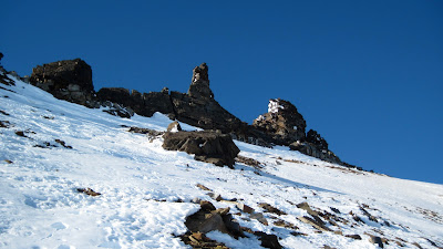
(above)  Osborn from the northeast.  Traversing icy slopes to the right underneath the row of summit tors to get to Osborn's high point, you are traversing over the great sinister wall holler of the Northeast Face.   The moves are not difficult, but you would not want to snag your bell-bottoms with your crampon points.  The regular route on Osborn comes up from the left (southeast) and traverses the summit ridge;  a rope can be of comfort on this summit ridge in alpine conditions.

 
(above) Northeast wall Osborn, March 2011. Earp demonstrated the climber inside her is still very much alive by gunning the throttle through a series of spiritual and situational green lights for all-out attempt on the Sluicebox Couloir.  We roared into that dreadful cul de sac on March 13, Joni's birthday, with guns loaded, ready for fearsome struggle.


(above) Earp on 4th pitch of Sluicebox  Couloir.  Both of us had felt the sting of Osborn's northeast wall before.  On another of Joni's birthdays in 2006, we had gotten halfway up the Sluicebox before a breeze sprang up on top, nearly drowning us down in the cleft with waves of spindrift.  Joni had been nauseous the entire climb and able to speak only in low groans.


(above) Upper half of Sluicebox, March 13, 2011.  But when we got to the wall last Sunday (supported on snow machine by Quinn, fresh from the ritual of pure madness known as the Nome-Golovin snow machine race) we instantly perceived that our route was anemic.  Where there should have been an ice hose dribbling down the upper wall, there was only cold marble.  Some elementary force of nature, probably the great South Wind event of February, had denuded the wall of its promised ice.  Gone are the freezing-rain layers of Thanksgiving and New Year's, if they ever existed at all at this altitude, in this frozen cauldron.  Compare this picture from a week ago with pictures of this wall from years earlier (below):


(above) Osborn from Grand Central.  The Northeast Face, and the Grand Central Glacier at its foot, is around the corner to the right.

       Upon finding the Sluicebox NOT WORTH CLIMBING IN THESE CONDITIONS, the effect was like waking out of a deep trance.  "What are we doing here, Earp?  How did we get here?"  We stood blinking in the bright sunlight.  So focused had we been on the NORDWAND, now that we were released from years of servitude in the gulag, we didn't know what to do with ourselves.
       If the gold medal for valor was not to be our reward this time.  I peeked in to my little black book for other nearby opportunities to conflate my sore and collapsed ego.  How could I contrive some new frontier out of the mountain wilderness at my disposal?
       "I know, Earp-  let's make the FWA (first winter ascent) of Mt. Osborn by the regular route."  As far as I knew, the mountain had not had a proper ascent to the true summit during the calendar winter.  Nor has it yet, by my reckoning, as you shall see, unless you count the leveling of an ice ax to the proper altitude an ascent.  Joni was plenty psyched to climb Osborn, having never ascended the crown jewel of the Kigs in any season.  Such contrivances as FWAs are generally poo-pooed as proper motivation to climb by the spiritual masters of true alpine wisdom, but a confused old dad like me finds they provide a structure of sorts upon which to pin decision-making, and energy resource allocation in a fatigued market.  So we motored around the corner of Osborn, parked our iron dogs in the sun, and commenced slogging up the southeast rib.   Earp, breaking training from WEIO,   was soon far ahead out of sight up the mountain.

    
(left)  "Snakey  Mt."(Pk. 2950+) and "Pen Tri Cwm" (Pk. 3600+) from the south fork Grand Central area.  These are peaks in the very cool South Fork of Grand Central, you see them to the south as you're hiking up Oz.  The pass to the right just out of the picture leads to the Windy drainage and is easy, though I've always been too chicken to MACHINE IT.  The saddle to the left of Snakey leads to the Sinuk, but is probably Class 3 or 4, so it is best for those seeking passage to choose the Windy/Sinuk side of Snakey Mountain.
      Years ago, Mikey and I slogged up the very ski-able backwards-S couloir on the lefthand mountain in the photo, which she later labelled as "Snakey" on a photo, which is how I have referred to it ever since.  Tyler calls it the "Z-couloir.  We are both in agreement that it represents the next great problem in Kigs descents— perhaps it's been hucked already.  The two pitches on the summit arete were steep and icy and made me glad that Mikey and I had brought a cord.  "Pen Tri Cwm" was a name bestowed upon the righthand peak by Todd et al in a Scree article, if I read it correctly, the name referring to its position at the head of three different valleys, Sinuk, Windy, and Grand Central.  A cool name for this mountain, which maintains a rather managerial prominence over the entire corridor of the Sinuk when viewed from the mouth of the Sinuk river--  I wonder if there's an older name from the early fish camp days? 
(above)  Looking south from the summit of Osborn.  Background peaks:  Snakey, Tre Pene Cwm Idi, Tigaraha, Turncorner Mt., Mosquito Pass Mt. and a chunk of Osborn's seldom-visited West Wall in the foreground.  The Hands-Full Factor was a bit high this time on Osborn's summit ridge--  the peak seems always to be embedded in a cold, upper stream, hands seem to stay inside gloves, cameras seem too imminently droppable to risk extracting from the pocket.

(above)  Summit tors on Osborn (not the actual summit) taken on descent.  These tors run like a fence along the top of Oz;  you HAVE TO traverse all the way to the north to reach the highest one, which is only higher than the penultimate one by probably ten or fifteen feet.  The Penultimate Tor, located at the southern end of the fence is the more spectacular formation;  on one of my earlier attempts I mistook it for the high point and rope-soloed it, finding moves at about 5.6, but then had no more time to traverse for 25 minutes to the north to get to the one that looked highest.  Roman may have soloed the Penultimate in the nineties while he was scientificaneering in Nome, but all is fog and uncertainty, it's hard to say.  The North Tor is easier, Class 4, or maybe Class 5;  I would say DON'T bring the rope in summer, but the thing can be useful snagging two people tied together by one when they are whizzing down the icy face in winter. 
       Earp had no love for the summit slopes and their bottomless chutes into wall holler;  she suffered my intimacy with the summit tors, my fabricated little rules for proper conduct when claiming ascents of Osborn, the merciless icy wind, and the way I foodled around in the scree and bullet-hard ice, picking my way ever so slowly across easy ground.  Many say they have climbed the Oz, some will tell of driving snow machines to the top--   but most, upon interrogation, reveal they merely reached the summit ridge, and do not deem the tors poking out the top of the mountain worthy of including in their definition of ascent.  
     The theme is contrivance as a motivator.  Without the conventions of traditional ascent, one would be content to stop short of the summit and there would be no game to play, no reason to escape the GLUE OF TOWN in the first place, no harmony of line or palette, no winner of the Iditarod.  And the rules need to be tailored to the particularities of a particular range.  I therefore propose that an ascent in the Kigs only be counted if the very topmost tiny rock has been attained.  
       I stopped short literally one meter shy of the top of the tor.  I raised my axe in the air, and it attained an altitude above sea level commensurate with the top of Osborn, 4714 feet.  It was not difficulty that stopped me from the last move, though, God!, you hadda be careful there, a thing just skids right on down and doesn't stop from there.  No, it was....  complexity, human complexity, I was paralyzed, transfixed, we had to get back home.  
             Therefore and hencefoth, Osborn awaits its FWA..
     

Thursday, March 10, 2011

Kayuqtuq, third attempt

          Ecstatic Spring weekend clusterJoy in the eastern Kigs, basing out of Earp's Rock of Ages home for not yet retired educators at Salmon Lake, the weather almost flawless, 10 degrees, negligible wind, traveling conditions a plane of perfect vanilla cream-- but due to partner's rucksack succumbing to Fell-off-the-machine syndrome, partnerless again in the high cirques for attempt number 3 on the mountain that I was this time calling (for my own personal silly referential reasons) KAYUQ, (Pk. 4000+) short for KAYUQTUQ, inupiaq for "Fox", which seems fitting for this peak which is located and visible from road at the head of Fox Creek drainage,  There are so many Fox Mountains already, who wants another?  If anyone has any information as to old Qaweraq names for this hill, let it percolate through, but I suspect no bubbles of name have made it to the surface of the present as the peak is rather secluded and unassuming, though it may possibly be the second highest summit in the Kigs, and unclimbed to boot.  (The U.S.G.S. maps I have seen smell a bit ambiguous as to its height.  They smudge the lines the way R.E.M. smudges lyrics.)
        If I have made this mountain sound like a brooding, inaccessible K2, it is not.  First of all, this is the Kigs we are talking about, a range for which the paradox is insoluble whether they are mountains or mere hills.  Second, KAYUQTUQ appears to be a walk up from the South from the Fox Creek drainage.  Each of my three attempts from the more precipitous north side have been beaten back by the same factors:  late starts, general disorganization, laziness, and chickenheartedness, which are not factors that would speak heavily for no one's technical difficulty other than my own.  But I will be back, and each attempt on old KAYUQTUQ, the tenth C-Tog technically, builds fond memories and deepens my love for the mountain.

Three views of Pk. 4000+ from last weekend's trip, March 05, 2011:

 (above)  From up in the east cirque of KAYUQTUQ (Pk. 4000+), the very headwaters of Crater Creek.  There's got to be a still-living nub of glacier in this cirque.  The route I followed was intended to be the path of least resistance:  up the broad couloir towards the left, then right along the easy back side of the south ridge.  The bowl at the top of the couloir was loaded, however.  There was evidence everywhere of recent and cataclysmic avalanching from the mighty storm two weeks previous, the tremendous south wind that had drifted everything around Nome in a weird and anomalous way and shut down town for three days.
      My paranoia spiked up like a dust devil off the desert.  The snowpack underfoot seemed to faintly echo with the sound of cellos.  Up above on the ridge, the cornices could be seen blowing gauzy banners of transluscent, rainbowed spindrift;  this gully was actively loading!  A massive chicken-out ensued, and I turned around.
 (above)  From the southeast near Salmon Lake.
 (above)  From the south, looking up Fox Creek.  Some dirtbag must have hiked up this mountain sometime.  You, reader, give a call, sharpen up your crampons, let's go this weekend....

 (above) Janet Balice and friends in Crater Creek.  A dog team in Crater Creek! Completely and absolutely something I have not seen in ten or more trips through here.   The irredoubtable DIBELS is in lead-cat position.  This is DIBELS second appearance in this blog in Crater Creek.  This team can cover some ground, let me tell you.  They started out from Nome late on Friday night, slept cold in Earp's bombed-out, blown-out cabin at Salmon Lake, penetrated into Crater Creek on Saturday, and mushed back to Nome via Eldorado Creek on Sunday.  

And now, another departure from the pure mineral indifference of mountain pictures... More dogs and humans superimposed on the snow, ice, and tundra:  friends!
(above)  Salmon Lake, looking south, Inuruq in background. Adhesion of TOWN GLUE is proportional for each individual in a party, meaning that, for a group to get out of town is no more or no less difficult than for one individual to get out of town.  The GLUE was fierce as usual, tragedy and psychological complexity lurking behind every move.  Ryan, Nikki, Carl, and me, already exhausted from the very trenches of public school education, headed out on the highway sometime near midnight.  Somewhere in the night we passed Janet and Dibels, detained as well by the GLUE, evidently. We'll get to the comfy cabin and pass out, was the thought that kept each person driving all night, bumping over sastrugi for numb hours in pitch darkness. 
        But there was to be NO COMFY CABIN.  Alai!  The monstrous South Wind had blown out a window. The familiar contours of the cabin's interior were coated over with snow.  The newly-installed drip stove had ripped apart in an avalanche.  Condition:  ICE STATION ZEBRA.  Instead of gratefully flopping onto snoring cots, we were bailing ship for hours and hours, ferrying little loads of snow out the door with our brightly-colored shovels until the middle of the morning.  Janet arrived expecting steaming mugs and warmth, and instead found people scurrying about grimly locked in struggle.  Through dint of Ryan's huge exertions the following day, the cabin was resurrected.  I could point to the epic of the cabin as the reason I didn't get up the mountain, But I know, to quote Jimmy Buffet, to avoid delusion,  it's my own damn fault.  
 (above)  Looking south from summit of Inuruq last Sunday.  Icy.  Loaded also, but windward-slope conditions still icy and good.

You better bring your buckets
We got some dreams to drain
I'll be at the bottom
I've been right here waiting so long
Just waiting so long