Showing posts with label Canyon Creek. Show all posts

Wednesday, November 4, 2015

Peak Thirty-Eight Fifty, Canyon Creek


Looking northeast from Valpa Pass. Pk. 3850 is the high point on the skyline near the left edge of photo. 
Pt. 2975, "Ray Creek Peak", on the shoulder of Pk. 3850+
          Through the umbilicus of Valpa Pass, into the maw of Canyon Creek went Mind riding.  Words shed their outlines in hot breezy sunshine until their meanings had vaporized and rendered translucent. The broad mile-wide canyon stretched northwest from the mountains opening out in the direction of the sea, the villages of Brevig and Teller, and the entire sweep of the Land Bridge coming across from Siberia, with massive energy bursts of CHI streaming from the northwest polar regions getting caught up in the mountainous catchment funnel of Canyon Creek where I hiked, entering the massive proscenium of the sunny canyon floor like a duchess entering a promenade, mind trains flowing behind me born aloft on great streams of mental wind.
Map of Pk. 3850+ expedition route, June 17 - 20. This route offered the most direct approach to  the Pk. 3850+, but the pass between Blume and Valpa creeks is rather high. Feather River and Johnstone Creeks also offer hiking passes into Canyon Creek from the Teller Road. All three of these passes are Class III on the north side. 
      A lovely little falls and schist pool poured out the bottom of Valpa Creek. Hadrosaurs grazed to the side in the willows on the floor of Canyon Creek as I began the crossing to the other side of the canyon. Trailing long trains of royal befuddlement, I began the promenade across the canyon, while every eye in that fifty square miles of mountain wilderness watched my every move, though I  saw none of their life forms moving now, save the relentless, peripatetic  fury of my own good dog, who had chased away the Hadrosaurs. Warm June breezes blew the bugs away, a man could have been naked in the summer in Alaska. Turrets of limestone and granite lined the ridge tops. Great power, though, as I've said, words are useless, and it's just a ceaselessly barking dog to be blogging about the wordless.
Looking south up Valpa Creek from Canyon Creek. 
Looking east up Canyon Creek to the beauteous Pk. 3300 (link).
        Suddenly, from the other side of a small hill, came the frenzied barking of my good dog. There was a certain tone to her barking, something urgent, something dire, something impending. She was coming back my way, barking, barking in full panic. I fully expected the little dog to come around the corner at any moment pursued by a herd of vicious Troodon, little chicken-sized, pack-hunting carnivores from the Maastrichtian Age.
           Like Jed Clampett, like Terminator, like Elmer Fudd, or Steven Segal in Valdez,  I rammed the action on the 12-gauge, and flicked the safety gadget thingy quickly to red, and FIRED that big cannon until the walls of Canyon Creek were resounding with thunder and my body was shaking with the hippy terror of it all, and then realized I had left the piece of protective duct tape over the damn barrel of the gun and was lucky I hadn't blown myself to pieces.
         Lucy came around the corner, sheepishly: she had gotten temporarily lost in the wilderness and had been yelling for Daddy. Guess I might have been a little on edge, totally SOLO in the deep psychological water of Canyon Creek, with all those.
Looking up Ray Creek
       Holy mountain, form of forms, sacred Thirty-eight Fifty, this is why I have come, to kneel at your feet and die before your beauty, then ascend to the tippy-top of your tippy top. You peek up and over the foreground tops of the western Kiggy Kigs, hiding in the back there, trying to blend in to the lower mountains as if you were part of them, but all the while that one strip of deeper blue on the top layer is actually you, oh Ray Creek Mountain, oh unnamed massif, looking over the tops of the other, lesser mountains, oh most high and almighty peak of all the Canyon Creek peaks, Peak 3850+, cousin to the great Singtook 3870. For a moment of intimacy have I toiled far from the civilizations of the Teller Road, over the high saddle from Blume to Valpa, and across the sun-filled breezes of Canyon Creek, to tick you off my ego list, and soak up CHI from your rock pores.
Looking southwest at Pk. 3870, the "Grand Singtook", from the summit of Pk. 3850+. Thirty-Eight Seventy and Thirty-Eight Fifty are big siblings at the west end of the Kigs.
Looking north from Pk. 3850+

East summit of Pk. 3850+, one of the humps on the "three-humped camel." The usual Kigluaik fearsome drop-off to the north, gentle slopes to the south. 
         White man, when presented with a mountain wall, will often ascend to the apex or highest altitude, where the wind itself might just as easily have slipped around to either side of the mountain, and so ascended I. Nice few thousand feet up easy Class 2 on the surface of bosom-like slope to the left of the cleavage of Ray Creek, rimmed by the granite tors of sub-Peak 2975, glimpses of some of the finest-looking rock in the range to judge by looking at it, though I lamely never walked over there, but at least the mystery was finally solved: Peak 2970 is the smallish chunk of granite visible  from various points of the range, about which various theories of mine over the years had now finally pinpointed it, here, right below me, high on the shoulder of Pk. 3850+.
A look into mysterious Fall Creek
Tors above Fall Creek, looking north
      Pk. 3850, a three-humped camel hoisted onto a broad-backed summit plateau jacked up higher than any other summit in the Western Kigs save its own analogue a short distance to the southwest, the celebrated Singtook, Pk. 3870. Tremendous view from the summit of Pk. 3850, north out over the sitting-duck graphite piles waiting to be exploited by outside agents from Canada, to the Imruq Basin and the Continental Divide beyond, and how fortunate that various self-judgmental juries of mental agencies had gathered together in kigsblog to place a "Mandatory North Side Mandate" on me which had required me to walk for three days straight, the preceding ten hours of hiking in one huge swath of effort for which I now stood, committed, in the middle of, at the top of the climb, the middle of the trip, with this stop-time view, on one of the most hot and sunny June days of all time.
Looking east along the spine of the Kigs from Pk. 3850+
Another look at Pt. 2975 at the head of Ray Creek
      Hours of incessant, ceaseless hiking wore on into the light of the night as dog and I reversed the hike to return to the forgotten yellow tent waiting back in the alternative universe from which we had originated on the south side of the range, my camp just below the high crest of Valpa Pass back in Blume Creek,  the huge uphill slog over Valpa still awaiting, though mental construction fields were destabilizing, and Sarah Hanson-Hofstetter's new tune was mercilessly lodged in my hippocampus resisting all attempts at the Blind Faith override for when a tune gets too stuck in my head after many hours of suffer-slogging.
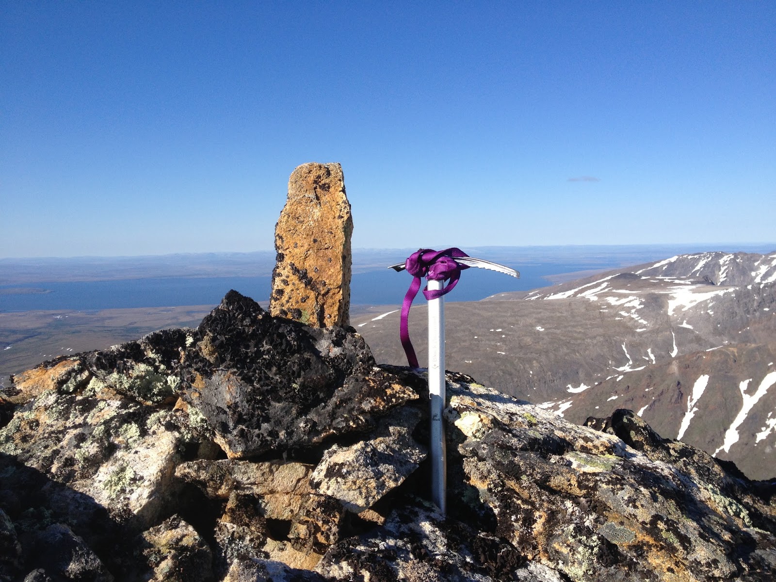
This obelisk at the summit of Pk. 3850+ was knocked over when I found it, but had obviously been put there by someone, so I re-erected it. Thought I smelled the scent of Amato on it.
Selfie of me and Lucy on the summit of Pk. 3850+, June 18, 2015
lord almighty god the crankloon generals in my head marching to bippety-bobbety bass lines burning with nausea born of digesting muscle tissue, "Are you hungry?" over and over Sarah make it stop it's been so many hours hiking across the mountains, across the canyon, up the mountain, in this weird velvety buzz field of solstice midnight blue light, back across the canyon, back across the mountains, hippocampus para-temporal lobe feedback loop throbbing with endless tune-loop not even Sea of Joy can displace, folds in the tundra hillside like cerebral tissue where dog waited for long rests
Camp at the very top of Blume Creek, looking south to the Norton Sound. The strategy of camping on the south side of the crest, and then hiking for a big, giant, long day without a big pack to get to a north side objective, proved to be a viable one for a long June day.
 Sad to leave the reverso world of the North Side Kigs. Even now my awareness, firmly stuck in the city and the GLUE OF TOWN, longs to be back in the electro-magnetic wash of Canyon Creek, the purplish fuzz of the cool-down hour at June Solstice time when the mist drops and the roar of water hushes, my paleo-wolf and I scanning the landscape for Troodon.

Tuesday, May 1, 2012

(Pk. 3300+) Canyon Creek

      The measure of a valley is the degree to which it and the surrounding peaks radiate a certain type of energy:  sinh tala, after the interior Athabaskans, or maybe just chi.  But measure requires a unit, and there is no established unit of measure for chi because the Uncertainty Principle renders chi too unpredictable a form of energy for quantitative measure, one only "feels" it qualitatively.
        Whatever, Canyon Creek in the western Kigluaik Range is a valley that exudes particular waveforms of this energy.  For so long I had tried to access Canyon's mysterious interiors, but like Alice at the door to the garden, had been denied, until 2SA weekends ago, when Rick Anderson and I finally managed to find the right pass into Canyon Creek on snow machines, in sunny Spring traveling conditions.   
(above) Pk. 3300+, Canyon Creek, Kigluaik Mountains, April 14, 2012.  I ascended via the easy slopes on the righthand side, treating the opportunity as a mere peakbagging exercise, wussing out of more challenging lines due to a good excuse:  a good friend waiting at basecamp who deserved better than to wait the extra hours a more technical line would have required.  To be fair, even the lowly Class 2 slopes sported some AI1;  you wouldn't want to trip on your pantlegs, or you'd go whizzing down the slope at a high rate of speed! 


(above) Map of Canyon Creek area
   A.  Snow-machine pass of choice to access Canyon Creek from the south. 
   B. Pk. 3300+.  Climbed to summit via easy southwest slopes.
   C.  Untouched gneiss. 
   D.  Pk. 3850+.  Highest peak in the area.
   E.  Canyon Creek
   F.  Pk. 3390.  Climbed last year.
   G.  Blume-Valpa Pass.  Easy hiking- maybe not so good for machine.
   H.  Pk. 3195.  Also climbed last year.
    I.  Johnston-Canyon Pass.  Easy hike. Possibly snow-machinable.
   J. Johnston-Right Fork Pass.  Class 2.  
   K. Inuksuk Pass (American-Right Fork) Interesting set of manmade rock piles.
   L.  Pk. 3000+.  Climbed year before last 

(above) Pk. 3850+.  This mini-massif may be the fifth highest independent summit in the Kigs, depending on how you define "independent summit"— (My unofficial list: 1. Mt. Osborn (4704)  2. Osborn's northwestern neighbor, Pk. 3998   3. Grand Singatook (Pk. 3870) and 4. Kayuqtuq (Pk. 4000+ ?)  Peakbagging the summit in the above picture was my primary objective this Canyon Creek trip, but Pk. 3300+ up canyon seemed like a nicer place to be, so we camped there.

(below) Gneiss towers on the southeast shoulder of Pk. 3850+.  The wall in this picture has, on very rare occasions from certain summits, flitted into my frame of perspective through lined-up corridors of mountain, but its exact location remained hidden in the geologic folds until this trip, when Rick and I turned a corner on Canyon Creek to discover its true location.  


The NO-SKETCH PARTNER LAW is stated thusly:  the scope of your climbing ambitions must conform to the mean climbing ambitions of the group.

     What this means is, you can't be an asshole.  We've all had that kind of Comstockian partner who is ready at a moment's notice to bail from the corniced ridge on which you both are standing.  Some alpinists have no natural ability to execute the crucial task of NON-CLIMBING when the conditions permit, and these are the ones who seem strange and extremely self-centered within a group in, or going to, the mountains.  Such a climber cannot hang except with those of their own kind.  It takes great effort.
      On Friday, 3SA, as Rick and I were packing for our weekend trip into Canyon Creek, I saw a post on Supertopo by a friend of mine:  Jabber's thread on Supertopo .   He was bailed on by a mancrushed partner!  Huge arrangements had been made and dates precisely calibrated for the two of them to escape the GLUE OF FAIRBANKS, but at the last minute, the guy goes "off with Bridwell" to some other mountain.  Clearly, a violation of the NO-SKETCH PARTNER LAW.
(above) Rick Anderson at the "Snow-machine Pass into upper Canyon Creek," looking south.  (The one labelled "A" on the map.  Gneiss unclimbed tor in background!

(below) Upper Canyon Creek from Pk. 3300+, looking southeast.  The Snow-machine Pass is at center of photo.


      I was psyched!  A friend to go to the mountains with!  And a fellow Kigluaik lover who's been all over these hills on foot and by dog team.  It's so much fun doing trips with Rick because we can sit around like long-lost brothers discussing extremely obscure minutia of hill and valley, and never grow bored with it.  
      But first we had to escape the GLUE OF TOWN.  Over many weeks of winter, the GLUE OF TOWN had gotten Rick pasted down like a victim from the movie Alien, but I was certain the lure of a trip to the Kigs in perfect April weather would loosen the bonds of the slimy substance that coated him.  I offered him my best old mount, Crusteo, the Polaris .340.   The GLUE began to loosen.  We hacked at it with our machetes, carving away excuses, harboring sleep throughout the weekdays, patiently unraveling obstacles.  My wife Kristine, who possesses the magic power to either dissolve or intensify the GLUE with the slightest look, was blowing in our favor;  someday soon Kristine and I will wage our own war on the GLUE and escape together, but for this weekend it was Rick and I, and I was mighty glad of it, someone experienced with whom to share the adventure.   

(below) Rick power lounging at Canyon Creek basecamp, base of Pk. 3300+.
(below) Pk. 3300+ from south.  This photo was taken in June 2011.  Rick, note the fresh, cataclysmic landslide in that gully we were hanging out in behind camp—  Is that why I felt creepy in there?

(below left and below right)  Inuksuk.  I found these homunculi on a previous reconnaissance to Canyon Creek, at the pass marked "K" in the map above.  I know nothing about how they got here, only that it looked like a likely place to herd reindeer into a ravine.


        Solitude is jagged and hard, a bare floor.   All it takes is another mind in a lonely valley to warm the place up, no matter how cold the temperatures, no matter how far from town you might lie.  So enormous is the contrast between a trip into the Kigs with friends, and a trip to the Kigs with no one, that my brain cannot even grasp the disparity;  they are two different mental modes, the one primitive and speechless, the other easy and confident. Both are necessary for wisdom, I cannot turn my back on either.  But it is very hard to fight the GLUE alone.  I am deeply grateful for the friends I have found, for the times we have had huddling in the wind and surreal beauty.

(below)  The Grand Singatook (Pk. 3870) from the north. Nils Hahn and I had a great trip here sometime in a June of the 2000s.  We came from the Teller Road seeking the ultimate Nordwand of the Kigluaik on the back side of the Singatook:  instead we found a two-thousand foot snow-slope capped by two or three pitches of easy Scottish-gully ice.  Why are my climbs always skiable?  


Wednesday, September 28, 2011

Pk. 3390 and Pk. 3195, Blume Ck.

15SA, Spring viewed from Fall...

       (above) Lucy near summit of 3390, at the head of Blume Ck.  She balked at the actual summit pinnacle, which required, in her mind at least, following me down the 5.5 down-climb in the picture;  there's probably a way around this obstacle, but she never found it.  
        O.K., so maybe the 25 ft. summit pinnacle is only 10 ft. higher than Lucy's high point shown here.  The rule is:  you have to get to the very highest, most tippy-toppy point, or it doesn't count.  Without this rule in place, climbing in the Kigs would legally be rendered "ridge-walking" rather than climbing.   


       June:  summer stretched ahead.  Serotonin flowed from springs that would never expire.  The GLUE OF TOWN was effortlessly overcome.   The requisite self-centeredness necessary for escape velocity was easily achieved, as Lucy rode strapped in the dog box on the back of Prolly, trusty 4-wheeler.  Towards the western range we penetrated, that surreal terra incognita which is the visible part of the Kigluaitch from the village of Teller to the northwest, where no Kougarok Road crosses the Kigs with its urban hordes.  
       If people know any of the true names of particular mountains over by Canyon and Cobblestone, float them over these techno-mind waves, please, quyana.
       (above) Summit pinnacle, Pk. 3390.  One, Class 4 move perched over a respectable void at the summit of an otherwise boring ridge...   Condition:  foghead


       Things feel strange to me in the Western Kigs.  When you're at Salmon Lake over on the eastern side, Pacific Ocean feels far away, but here in the West, Woolley Lagoon is licking its foggy, windy head into the valleys at all times.  The rock itself, a special blend of metamorphic stew, affects the psycho-electromagnetic nonentropy fields of this region in ways that cause time distortion and shamanic dimensional-interface.
       (above) Prolly the 4-wheeler encamped for a few days at Feather River, haunted by the ghosts of her ancestors buried near this spot, the World War II junk-pile where they put everything under the ground when the war was over, Or SoI'mTold..


       Set out with the Border Collie on her first trip to the real mountains.  Trying to discover the best direct hiking route from Teller Road to Canyon Creek, stalking a hidden giant out in the cortical folds of inner Canyon Creek, a region about which I know nothing.  
     Conditon:  foghead.  Silks and wreaths of fog swirling tantalizingly around the shoulders, glimpses of eyes through the 3,000 ft. cloud ceiling.  Beautiful, yet always that familiar, flat, oppressive feeling bearing down on thoughts and hopes, claustrogo, the weight of opacity, fog, mist, creating a dreamlike sensation,  as if all of this were a scene from a Lost In Space episode. 
       (above)  Pk. 3390, south ridge.  This image weighs in on the side of the argument that the Kigluait are only hills.  But what a fine fell run this ridge provided, up among the shifting heads of fog.
      Deceptive argument, however...  within this bland, low-resolution exterior lie hidden hollows of boulder-hole and northern drop-offs.  In winter, this peak might pose a more formidable challenge even than Scotland.


       This trip happened when summer was young and strong and stretching ahead like an endless road.  This 15SA trip, it seems almost naive to say, as viewed from the charred wreckage of present Fall, was a fun trip.  Lucy and I camped way up at the top of Blume Creek, right below the Class II pass that leads from Blume to Valpa Creek.  I hiked/bouldered up both peaks at the head of the pass, Pk. 3390 (Blume?) and Pk. 3195 (Valpa?). Both walk-ups, no real radness, except for a very brief traverse through the summit rocks to get to the Class 4, 25 ft. summit pinnacle, complete with hanging choss Volkswagon registering proximate death-attractor metrics on certain loose-rock scales.  
drift-bank foghead in the Alzheimer' eternal sunshine of the spotless mind,  
bottomless breathing upward valley-draft through the strip-dancing wave, 
saw the granitoid rumors vaporizing into reality for sure, 
glimpsed pinnacles and towers through channels lined-up in the memory loss, 
sing out if you see the granite! 
there is a hidden lake beyond this picture (above and below), Pk. 3300, 
the western lake where lie the hidden dragon vaults of the sacred sought-after igneous, 
oh wondrous healing rock, 
a western lake to fly to, fly to in the jingey-copters, 
to plunder the hidden spoils of all the western range. 


(above) Lucy in peril.  In this picture, Lucy is actually arm-barring hard off that right paw.  She has no footholds, her hind legs are paddling in space;  it's a bottomless crevasse, with a 10 ft. drop down to a gravel creek bed.  Notice the polite look on her face, one ear drooped:  uh, Daddy, how about you doing that ice climbing thing you're always doing and CLIMB DOWN HERE AND GET ME!  Indeed, I felt the need to fetch my long ax off my pack before making the rescue move, and also took the time to snap this picture while Lucy held the arm-bar.  
(above) Camp at head of Blume Ck., June 2011.  The snow made for great walking and glissading on the pass between Blume and Valpa--  ValpaBlume Pass.  Hard to say if snow-machinable:  could be a bit of a blow-over on the north side, who's ever gone over it?  Here's a map (below) to jog your own fog.

Monday, June 14, 2010

Peak 3000+, Southwest Ridge

  WHY AM I COMMITTING THE WRONG I'M ABOUT TO COMMIT?  I've become a stamp collector with a little album.  I have used Photoshop to type little numbers on the mountains, which I shall now categorize, classify, number, name, shuffle, and dote over.  Even more absurdly, they're only the Kigs, barely even big enough to qualify as mountains, mere dunes, really.

   Answer:  I'M HAVING SO MUCH FUN DOING IT.  There is something about the Internet, with all that consciousness pulsating through each keystroke, that is blowing away my lifelong writer's block.  Every unit of suppressed spray accumulated over years is coming bursting out, accompanied by features formerly poo-pooed, such as maps, pictures, and route descriptions of climbs which are not even climbs at all, but firmly belong in the category of hikes, such as today's feature.  Blame it on the utter transparency of the Matrix.  Couple this giddy loss of cyber-inhibition with the giddy fun of hiking and climbing in the Kigluaiks, and click!, you have these transgressions.  I invoke the Alex Lowe theorem: FUN is the measure of the climber. 

"...Go out and have entirely too much fun..."    Doug Buchanan
(above) Pk. 3000+,  one of the high points on the divide running west from Glacial Lake.  Class II.  It was a hike-up.  I got a funny feeling it has been ascended before.  My first foray of the summer into the high Kigluaiks, the well-springs of power, chi, prana, sinh tala in Athabaskan.
(above)  The ridge took about an hour.   "The best climber in the world is the one having the most fun."  It was so much fun last week to simply be hiking up a little mountain,  not surfing around my own event horizon on a death-pile.
(above)  Looking east around the bend of upper Johnstone Creek canyon.  Pk. 3000+ in background.

     MY EXCUSE for LAMENESS, for not seeking out a pocket of true, TECHnical climbing:  this was an exploratory trip. 

    Never had I properly explored the western side of the Kigs, it was time to do so.  The goal was to find a southern approach into the Kigs from the Teller Road into Canyon Creek, where lurks granite.  The GLUE of town was attached to my ass like a stretchy tendril, so I couldn't stay in there long enough—3 days, 2 nights— to do justice to my explorations.  The resistance of the GLUE was greatly increased by my extreme and irrational BEARONOIA, though once I got out there with my cannon slung over shoulder and madly singing, I saw literally no critters at all the entire three days.  

    So, what follows, simply because it's so much fun, is a little panoramic indulgence.  To a true Kigs enthusiast it would prove irresistable and might help mediate the disgust you should feel at this public disrobement of beauty.  It should also remind you somewhat of a dog trotting in circles peeing in various places systematically and with great enthusiasm.  Do dogs not have fun when they do this?  And is not FUN the justification for today?

Thanks to "Bedrock Geologic Map of the Kigluaik Mountains," by Jeff Amato and Elizabeth Miller.  I am butchering the geology.

(above)  View looking east from summit of Pk. 3000+.
1.  Tigaraha.  Means "finger" in Inupiaq. I've climbed it by at least 3 different routes, with Mikey and Lahka, but don't know who made the first ascent. Gneiss.
2.  Pk. 3367.   Visible from many places. A landmark.  Cobblestone headwaters. Deserves a name.  I've always called it "Three Gables" ("Tikilik" maybe?).  Climbed it solo one Iditarod on a mystical snow-machining day. No idea about the first ascent. Schist.
3.  One of the Grand Central or Crater Creek peaks.  It's probably Fox (Kayuqtuq), poking up from behind.  Currently stalking this one. Gneiss and schist clashing zone.
4.  [i think] One of the Grand Central peaks that form the right side of Grand Central, Pk. 3190. I always call it the "Mother." ("Aana").  Snow-climbed it one spring via machine. Schist, as are the next two.
5. A little Grand Central peak, 3290 [i think]. I always call it "the Child" ("Uiviilaq").  Skiied with Tyler and Keith one year.
6. Tallest Grand Central Peak besides Osborn, Pk. 3922. The "Father" ("Aapa"). Cramponed up with Phil on a very cold January day.   
7.  Mt. Osborn, Pk. 4714, King of the Kigs. First ascent unknown, at least to me. Do not leave comments reminding that it does not matter, we know this. Maybe it was Osborn first climbed Osborn?  Probably a hunter from Beringia.  It's only a rolling, flowing lump in the mantle.  My understanding is that Osborn is a giant chunk of "meta-sedimentary" marble riding up on the pluton.


(above) Looking northeast from Peak 3000+.
7.  Osborn, with [probably] unclimbed west face.
8. Pk. 2490. Just north from Glacial Lake on the right.   
9. Pk. 3320. I mean the peak down below the little red "9".  
10. The north peaks of Osborn. (one on right higher.) 
11. Suluun, the Dorsal Fin. Andy and I did 3 routes there. 8, 9, and 11 are a line of the orthogneiss, pink on Jeff's map.
12. East terminus of a line of jagged peaks visible from Teller. Are they the "Sawtooths"?


(above) Looking northwest from Pk. 3000+
12.  I've heard them called the "Dragontooths" and the "Oro Grande".  "Sawtooths" works.  Ascents by Amato. A ridge studded with granite tors.
13. Pk. 3700+ over by Falls Creek. I would like to know more about this area.
14. Pk. 3300+.  Granite.  I suspect it of having non-hideous rock climbing.
15. The mysterious 3850+.  One of the higher elevations in the range.
16. Canyon Creek.  MUCH more searching for real climbing to be done.

   O, my offense is rank, it smells to heaven...
    It hath the primal eldest curse upon't—
   
And yet, here's one more.  A sign of aging, plus extreme self-centeredness, plus lack of job.


(above) TR region, Johnstone Creek area
1. Pk. 3000+
2.  Inuksuk pass (see below)
3.  "Johnstone/Right Fork Pass" I had good walking on snow fields, probably a doable snow-machine ride in winter if there were not cornices..." 
4.  Pk. 2930 a slice o' the gneiss
5. Pk. 2710 couple of hour backpacker's climb, I didn't get to it.
6. Another way to get over to Canyon Creek. I'd wager it's machinable.
7.  Pk. 2345  I climbed a little 5.7 on the summit tor;  this is a classic hike.
8.  My bearanoid campsite, out of the way of the main corridor. 


(above) inuksugait  Strange to be surrounded by homunculi in the lonely mountains. Here is a link about rock piles that took seconds to find:

...and so there ain't nothing more to write about, and I am rotten glad of it, because if I'd a knowed what a trouble it was to make a book I wouldn't a tackled it, and I ain't a-going to no more