Showing posts with label Grand Singatook. Show all posts

Wednesday, June 20, 2018

Fall Fell


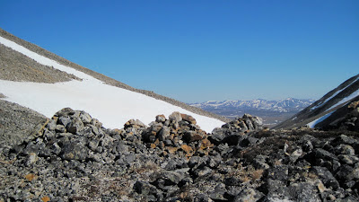
Bouldering on the way up the south ridge of Peak 3260, "East Singtook"
Peak 3260  
     Blog-lag considerably swollen. Writing of Fall adventures from late Spring. In this post, more sacred secrets will be given away, this time the location of one of the best roadside fell runs on the Seward Peninsula: four miles of gradually ascending ridge to the summit of the East Singtook (Pk. 3260), with a surprise set of gneiss pinnacles in the middle section allowing the rare mineral of actual climbing. Also in this post: the mysteries of the Little Singtook's (Pk. 3653) North Face will be probed, as well as little turd-clumps of climbing so small and unstable they are destined not to stand into the next Millennium. 
Grand Singtook (Pk. 3870) and Little Singtook (Pk. 3653 - "Sintauyuq?") from East Singtook. This pair form a prominent landmark, which is probably why a name was bestowed upon them from days of yore.
Marianne in glue
        No doubt the GLUE of TOWN ran high that September weekend as two teachers drove west. No doubt the tack was high due to the responsibility of a new school year in session. With each unit of distance away from town, the GLUE retracted us backwards toward town an equal number of units. The extending filaments of GLUE did not start peeling off us until Nick and I had travelled twenty miles west on the Teller Road and crossed the Sinuk River. We began to forget about town, and about school, and the GLUE no longer asserted its influence upon our thoughts. We continued another ten miles west from the Sinuk and parked at Crete Creek to start our fell run up East Singtook.
A lightfoot lad raised in the Chugach
       A sentient but somnolent mist dissolved everything in and out, like a bad transporter beam. Nick could have lapped me several times, but kindly waited on the benches in the shivering wind. For me this was a mere peak bagging expedition, a statistical quest to stand on top of Pk. 3260, the "East Singtook." From the road, the ridge had always looked boring, a hike for tourists, with no climbing at all, which is why I had  skipped it all these long years, until-- the silly conceit of climbing every peak in the Kigs overtook my motivations like a disease and rendered me a mere hiker, not a climber. Now Pk. 3260 seemed desirable. But a surprise awaited in the crook of the south ridge that you can't see from the road.
Routes taken this Fall, 2017


Too cold to switch to rock shoes
      The pinnacles of Pt. 2875 suddenly popped up in the middle of the ridge! A hiker can easily side-hill around these outcrops, none of which really exceed six meters, but Nick began to navigate a little tightrope game through the pinnacles where you have to follow the exact crest of the ridge over the mini-Stegosaur's back of rock, and it was so fun to follow his heels doing all kinds of little boulder problems, both highball and low. Geologically, the rock had been granite before it was gneiss; cracks, knobs, and slabs emerged from the palimpsest of metamorphism. The ridge took us across 400 horizontal meters of cool little boulder problems, and out into the "you're going to be mangled" zone more than once. So our fell run contained this cool simulation of a real alpine rock climb. 
Fell running action
         Did I mention it was cold? Well, duh. There was to be no pleasant picnic in the sun that day. Vapors off Woolley Lagoon slapped into the Singtauyit slap after slap. The view kept pixellating into zones of grey before reloading the details between cloudbursts. A few of the most badass survivor mosquitoes tried to fly up between eddies of wind, then realized they were useless and activated their rescue beacons. Fall is the coldest season. Gloves, hats, and long johns are still buried under summer's gear, and cannot be found on a GLUE-stricken morning. Perhaps one lacks fatty tissues. The settings on one's bio-thermostat have not been recalibrated. Cold? Yes it was, alaapah.  


Evidence of uplift. In the background is the Singtook, adorned with its usual raiments of gale-force wind.
     Not only was the summit of Pk. 3260 another Marilyn notched in the silly, statistically-fabricated belt of a peak bagger, you could see lots more pointy Marilyns ripping clouds all up and down the range. Down the west ridge with airplane wing arms I followed Nick for an excellent downhill-running session. This led down to the saddle between the Grand Singtook and Little Singtook at the top of Crete Creek, the East Col, a place about which I had always been curious: would this pass go, or was it the usual Kigsian precipice to the north? Back in the two-thousand aughts, as a prelude to Nil's and my ascent of Grand Singtook's north face in 2003, I had invested significant amounts of time and energy to researching the question of this East Col, on several occasions hiking all the way around the Singtook from the west and getting terrifyingly lost in fog and furious wind. Back in the day, it took me forever to form a mental map of the confusing topography around the Singtauyit and I would wander like a dreamer in Wonderland, coming upon lost cirques full of ice and stone, with no real concept of how the hills and drainages fit together. 
Big league trundling action, looking down the north side of the Singtook South Col
    The pass looked like it would go to the north with some hideous Class 4 down-scrambling. I was happy that Nils and I had accessed the north face from several hundred feet higher and not gone down this unsavory chute. "Hello, is anyone down there?" I yelled, as if. We commenced trundling. Nick pried at enormous blocks with his runner's body like a shovel about to snap. We got on our backs and pushed with our legs, then popped upright, ran to the edge, and watched the explosions with the same sick fascination one watches crashes on youtube.

       There you have it. What value in all this verbiage? What right have I to chronicle a mere hike in the annals of a blog which is supposed to be about real climbing? 
Well, now you know the location of one of the finest roadside fell runs on the Seward Peninsula, that is something.


Singtooyit from the North. Grand Singtook in the center, Little Singtook to the right, and the East Singtook on the left barely poking up over a foreground peak. 
Granite Creek
      A splendid little fell-running community emerged out of the new school year. Nick bought a used Ford Bronco which served as an effective GLUE-cutting escape-mobile.  David joined us and we headed west on the Teller Road with GLUE filaments popping and peeling as we shed our psychological attachments on yet another freezing-ass, glorious weekend.
North Face of Little Singtook. Some of those white patches are ice. I went up partway and bouldered around.
      A movement was afoot to explore Granite Creek, around the corner to the northwest of the Singtook. For the fell runners, the fell run itself was a means to an end, but for this malnourished ice climber, the trip would be a chance to check out a new, north-facing cirque in the hope of finding Fall ice. Eighteen years in Nome has taught me not to get my hopes up, but Granite Creek seemed promising. With all my plotting and map-gazing to find north-facing cirques in the Kigs which are accessible in less than a day from the road, why had I never noticed Granite Creek before? The fell run would lead right up the drainage to the northwest face of Pk. 3260, which I have variously referred to elsewhere in this blog as the Little Singtook. Surely this cirque would yield a cornucopia of thick, blue, frozen waterfalls ripe for high-angle ice climbing.
Did I mention it was cold?
      In fact, it turned out I would be able to sink picks into ice, but there would be no satisfying "chunk," only an annoying metallic scraping and sparking as the pick penetrated through a thin shell of ice and sparked the rock beneath. There would be no runouts, no screws, no terror, no deep self-realization that comes with real ice climbing, only a few hurried moves over anemic verglas that had been disguised from below as real ice. But I could now check the box that said I had ice climbed that day. I could now return to town and tell them what a big-shot ice climber I was.  This was a few hundred feet above the tarn at the head of Granite Creek where a barely visible trickle of ice could be seen meandering its way across cliffs and talus. The ice did look as if it might grow with more autumnal freeze/thaw action, and I vowed to return the following weekend, but the GLUE was destined to rise up like a phagocyte and envelop my intention, thereby obviating it.
Da
Da
Da

Penny River Crags

          The next Fall weekend featured a trip out to a nameless blob of rock near the Penny River, with David. Only an aficionado of obscure bouldering could see any value in such a desiccated turd pile of twice-morphed schist, but I managed to talk David into the proposition that obscure bouldering was a type of DaDaist art form, which appealed to his avant-garde, culturally-refined nature, and he began to discern the emperors clothes that transformed a schist-pile into a jungle gym of fun. Besides, he was eager to play with his new crampons and ice axe, and quickly learned what a solid, reliable handhold was to be found in an axe sunken in frozen turf. We put up multiple major first ascents of numerous dry-tool problems including Taiguaq (Read It), Ayauppiak (Sun Dog), Suama (Fortitude), all of them so far into the V0— range of difficulty that their identity will soon fade, and their geologic structure erode.
Location of purported caldera

The Fox Creek Caldera Hoax

          Several years back, Mr. Collins and his cross-country team were developing the mountain running course destined to be the standard unit for all Kigluaik mountain runs in the future: Fox Creek. There he discovered a caldera, up at the very head of the west fork of Fox Creek. Our next, featured, Fall fell run chronicles an expedition to investigate this improbable geological feature. On a freezing-ass windy Saturday, a mass of fell runners consisting of doctors, lawyers, teachers, and dogs, headed up Fox, and hung a left at the sentient boulders, which are really donkeys that have been turned to stone through bad luck. A short series of moraines led to the caldera.
The fell running community of Nome

         A small tarn, a kettle lake, perhaps, lay at the center of a perfectly-round, glacial cirque. Any geologist will already know that our quest was absurd, a continuation of the DaDaist ethic that drove these Fall adventures. The point was all the fell running we did. I had heard theories of another caldera in the Kigluaik, this one located in the round cirque under Mosquito Pass Peak, as if the Kigs were a burbling bed of magma drizzled like salad dressing on top of a twice-subducted gneiss dome, with all the attendant glacial processes taking place on top of it.   

I had visited the caldera two summers before, when Lucy and I climbed up the hill above it.  This picture looks straight down into it, with Lucy napping on the edge of a fairly steep cliff.


Wednesday, October 31, 2012

Pk. 3653, "Little Singatook"

Grand Singatook (Pk. 3870) on the left, Little Singatook (Pk. 3653) on right. The Little Singatook is WEST of the big one.

      Fog was draining the snowy Kigluaik Range like mucus subsiding through sinus passages out towards the sea.  In the bright breathing sunshine left in the fog's wake,  Lucy and I were heading west on the Teller Road bound for the Grand Singtook, Peak 3870, the Mt. Washington of the Seward Peninsula, where hopefully a basting of ice garnished its walls and buttresses.  Time was crystallized that day, Sunday, 1 Saturday Ago,  there was only NOW, beauty wallowed in fields of itself, a total chi-fest echoed down the hallways of eleven-dimensional time/space.

(above) Northwest aspect of Grand Singatook (Pk. 3870) taken from "Singtairuq" (Pk. 3653), Saturday, October 27, 2012.   In June of 2004, Nils Hahn and I climbed this side of 3870 by traversing down on to the face from a point halfway up the lefthand skyline (after drunken June bivouac on eastern slopes);  we finished in one of the Scottish gullies leading through the steep cliff band there at the top for three pitches. 

      The "Singtook" stands at the western bulwark of the Kigluaik Mountains;  it is the cleaver that cleaves the big weather systems flowing in off the Pacific.  Known to locals as "Thirty-Eight Seventy," it rates only a lump in comparison to Chugach or Alaska Range peaks, but nevertheless is a peak invested with psychic energy. 
      Imagine a family back in the day piled high into an Umiaq making what must have been a very worrying crossing from King Island to the mainland:  
          "Daddy— when is it ever going to end?"  
         "Just concentrate on the Singtook, my son, and reel that mountain in."
        Someone from King Island told me they looked for the outline of not one but two Singtook, a Big Singatook and a Small Singatook, which may explain why 3870 appears as Grand Singatook on the map, semantically implying there are other, lesser Singtut in its vicinity—  not to mention the -k ending on "Singatook," possibly indicating the amazing, inupiaq, "duple" plural ending.    
          The Singtook has a little "mini-me" of a mountain standing at its side, Peak 3653, the "Little Singtook" I once heard it called.  Having ascended the Big Singtook various times by various routes with various people in various years (tallying less than 50 percent success rate on this notorious wearer of storm hats), a climb of the Little Singtook—   Pk. 3653 on the map, the Singtairuq—  was now in order.  So that's where Lucy and I were heading in the vaporous heaven of sunshine last Saturday morning.


(above) Teller Road, dissipating fog.

(above) Lucy, 3870.

       Lucy bounded from the truck. Away we went up the gleaming southern slopes of 3870.   The big blue globe of Woolly Lagoon dropped steadily away as Lucy and I made good time over hard frozen snow.  Soon found me donning my creepers to join Lucy's claws, but then taking them off again when granite rock fields intervened, then putting them on once more for good as we sloped onto the icy, frozen upper mountain, where a summit wind sprang up to greet us.
   
 (above) Pk. 3653 from the plateau lying between it and 3870.

    Singtook rose up now on the right as we crossed a plateau.  The recipe of sunshine, mountains, and wilderness had once again conspired to shift the nodal point of my seven chakraed energy body to a slightly different point;  what I experienced in my mind while one-step-at-a-timing it up the mountain was akin to an altered state.  The effect was in the temporal interface:  each moment passed as if through a telescoping lens capable of zooming out to my entire life, and back to the mountain again. 


(above) Summit tors of Pk. 3653.  The tor in the lower picture was judged the higher spire.  Both were ascended by path-of-least-resistance methods with Class 4/5 moves over rimed or snow-covered granite.


(above) Lucy perched on Class 4 summit of Pk. 3653.  SiNtuq in background.  This was actually a rather narrow and exposed summit, for one brief shining moment of real climbing in a life of constant slogging.

     A gift at the summit:  the high point appeared to be at the top of some small tors, meaning the climb might yet transcend the category of mere slog.  Indeed, massive chunks of de-rimed snow were thumping down on top of us, giving the locality a rather Alaska Range feel.  Since the snow bedecking the granite was de-riming, it wasn't much good for pulling on with picks, so I was forced to weave creatively around the tors on ledges, ramps, and blocks, in good Norman Clyde style, in order to access the tippy, tippy tops of both the highest tors.  
       Lucy began to whine and fret, questioning the utility of lingering in such a silly, lifeless place, with the late-October sun sinking fast behind King Island into the molten, burbling sea.
     But once again, human eyes had detected what the dog's keen sense did not—  the gibbous Moon, way over on the opposite end of the Range, already risen over Mt. Osborn.  There would be light aplenty.  Abandon this sense of haste and hurry, though night be falling soon.

(above) Looking east from Pk. 3653 down the spine of the Kigluaiks Range, gibbous moon to the left of Mt. Osborn.

         On the descent, I saw something I will not soon forget. Lucy and I were stumbling along in the gloaming, waiting for the Moon to pop up at our backs so we could see again.  The Moon was taking its time working its way over the horizon of the Singtook.  Meanwhile, the Singtook itself had put on THE MONSTER—  the localized, massive, lenticular cloud which often hangs stuck on the upper half of the mountain or curvi-formed in the air just above.  All mountains have lenticulars, but the Singtook runs a doozy;  it is no place to be.  Many is the expedition that has battled its way up through reasonable winds to the 2500 ft. level on the Singtook, only to encounter there a living, moaning, hurricane-force WIND CLOUD which completely precludes a summit attempt.  
        The Singtook was wearing its cloud, and the Moon rose directly behind it.   White light flared off the mountain, resembling aurora more than smoke.  Beams as bright as a spotlight, then with a sheet thrown over it, then bright again, blackened in the denser patches with sunspots, spasms of light streaming, flashing out, hallucinating.  The Singtook steamed in the night, it was a giant mound of dry ice in a black light Halloween display.  An equal display still smoldered in the west, oranges and reds melting down over Russia. 
       Such beauty gets into you, stays with you for a long time.  I still can't believe what a gorgeous day last Saturday was.  It makes me sad, life can be that beautiful, even for a day.  I must endeavor to serve others well, in exchange for having been given this unbelievable gift.  And thanks to the mountain for offering itself. 


(above) Map of climbing routes around Pk. 3870, Teller Road.
A. Pk. 3653, "Singtairuq"
B. Pk. 3870, Grand Singatook
C. "Eldorado Creek Buttress"

     The red line indicates my route up Pk. 3653 last Saturday.  Along the way you pass near a bluff, "Eldorado Creek Buttress," which sometimes sports a two or three pitch ice climb.  I stumbled upon this bluff lost in a whiteout one time;  since visited with a number of partners over the years, finding a paltry variety of ice conditions. It ain't Valdez— but it does provide relatively quick access from the road to a north-facing cirque in the Kigs near the 2000 ft. level, where ice can sometimes be found during Fall time of year.
      The yellow line indicates the "Solar Sidewalk," the regular route up 3870, which passes by a high lake for swimming in the summer, and which makes a CLASSIC car-to-summit-and-back ski in the late Spring.
      The green line shows approximately where Nils and I climbed the North Face of the Singtook (III, WI2) in June, 2004.

Tuesday, May 1, 2012

(Pk. 3300+) Canyon Creek

      The measure of a valley is the degree to which it and the surrounding peaks radiate a certain type of energy:  sinh tala, after the interior Athabaskans, or maybe just chi.  But measure requires a unit, and there is no established unit of measure for chi because the Uncertainty Principle renders chi too unpredictable a form of energy for quantitative measure, one only "feels" it qualitatively.
        Whatever, Canyon Creek in the western Kigluaik Range is a valley that exudes particular waveforms of this energy.  For so long I had tried to access Canyon's mysterious interiors, but like Alice at the door to the garden, had been denied, until 2SA weekends ago, when Rick Anderson and I finally managed to find the right pass into Canyon Creek on snow machines, in sunny Spring traveling conditions.   
(above) Pk. 3300+, Canyon Creek, Kigluaik Mountains, April 14, 2012.  I ascended via the easy slopes on the righthand side, treating the opportunity as a mere peakbagging exercise, wussing out of more challenging lines due to a good excuse:  a good friend waiting at basecamp who deserved better than to wait the extra hours a more technical line would have required.  To be fair, even the lowly Class 2 slopes sported some AI1;  you wouldn't want to trip on your pantlegs, or you'd go whizzing down the slope at a high rate of speed! 


(above) Map of Canyon Creek area
   A.  Snow-machine pass of choice to access Canyon Creek from the south. 
   B. Pk. 3300+.  Climbed to summit via easy southwest slopes.
   C.  Untouched gneiss. 
   D.  Pk. 3850+.  Highest peak in the area.
   E.  Canyon Creek
   F.  Pk. 3390.  Climbed last year.
   G.  Blume-Valpa Pass.  Easy hiking- maybe not so good for machine.
   H.  Pk. 3195.  Also climbed last year.
    I.  Johnston-Canyon Pass.  Easy hike. Possibly snow-machinable.
   J. Johnston-Right Fork Pass.  Class 2.  
   K. Inuksuk Pass (American-Right Fork) Interesting set of manmade rock piles.
   L.  Pk. 3000+.  Climbed year before last 

(above) Pk. 3850+.  This mini-massif may be the fifth highest independent summit in the Kigs, depending on how you define "independent summit"— (My unofficial list: 1. Mt. Osborn (4704)  2. Osborn's northwestern neighbor, Pk. 3998   3. Grand Singatook (Pk. 3870) and 4. Kayuqtuq (Pk. 4000+ ?)  Peakbagging the summit in the above picture was my primary objective this Canyon Creek trip, but Pk. 3300+ up canyon seemed like a nicer place to be, so we camped there.

(below) Gneiss towers on the southeast shoulder of Pk. 3850+.  The wall in this picture has, on very rare occasions from certain summits, flitted into my frame of perspective through lined-up corridors of mountain, but its exact location remained hidden in the geologic folds until this trip, when Rick and I turned a corner on Canyon Creek to discover its true location.  


The NO-SKETCH PARTNER LAW is stated thusly:  the scope of your climbing ambitions must conform to the mean climbing ambitions of the group.

     What this means is, you can't be an asshole.  We've all had that kind of Comstockian partner who is ready at a moment's notice to bail from the corniced ridge on which you both are standing.  Some alpinists have no natural ability to execute the crucial task of NON-CLIMBING when the conditions permit, and these are the ones who seem strange and extremely self-centered within a group in, or going to, the mountains.  Such a climber cannot hang except with those of their own kind.  It takes great effort.
      On Friday, 3SA, as Rick and I were packing for our weekend trip into Canyon Creek, I saw a post on Supertopo by a friend of mine:  Jabber's thread on Supertopo .   He was bailed on by a mancrushed partner!  Huge arrangements had been made and dates precisely calibrated for the two of them to escape the GLUE OF FAIRBANKS, but at the last minute, the guy goes "off with Bridwell" to some other mountain.  Clearly, a violation of the NO-SKETCH PARTNER LAW.
(above) Rick Anderson at the "Snow-machine Pass into upper Canyon Creek," looking south.  (The one labelled "A" on the map.  Gneiss unclimbed tor in background!

(below) Upper Canyon Creek from Pk. 3300+, looking southeast.  The Snow-machine Pass is at center of photo.


      I was psyched!  A friend to go to the mountains with!  And a fellow Kigluaik lover who's been all over these hills on foot and by dog team.  It's so much fun doing trips with Rick because we can sit around like long-lost brothers discussing extremely obscure minutia of hill and valley, and never grow bored with it.  
      But first we had to escape the GLUE OF TOWN.  Over many weeks of winter, the GLUE OF TOWN had gotten Rick pasted down like a victim from the movie Alien, but I was certain the lure of a trip to the Kigs in perfect April weather would loosen the bonds of the slimy substance that coated him.  I offered him my best old mount, Crusteo, the Polaris .340.   The GLUE began to loosen.  We hacked at it with our machetes, carving away excuses, harboring sleep throughout the weekdays, patiently unraveling obstacles.  My wife Kristine, who possesses the magic power to either dissolve or intensify the GLUE with the slightest look, was blowing in our favor;  someday soon Kristine and I will wage our own war on the GLUE and escape together, but for this weekend it was Rick and I, and I was mighty glad of it, someone experienced with whom to share the adventure.   

(below) Rick power lounging at Canyon Creek basecamp, base of Pk. 3300+.
(below) Pk. 3300+ from south.  This photo was taken in June 2011.  Rick, note the fresh, cataclysmic landslide in that gully we were hanging out in behind camp—  Is that why I felt creepy in there?

(below left and below right)  Inuksuk.  I found these homunculi on a previous reconnaissance to Canyon Creek, at the pass marked "K" in the map above.  I know nothing about how they got here, only that it looked like a likely place to herd reindeer into a ravine.


        Solitude is jagged and hard, a bare floor.   All it takes is another mind in a lonely valley to warm the place up, no matter how cold the temperatures, no matter how far from town you might lie.  So enormous is the contrast between a trip into the Kigs with friends, and a trip to the Kigs with no one, that my brain cannot even grasp the disparity;  they are two different mental modes, the one primitive and speechless, the other easy and confident. Both are necessary for wisdom, I cannot turn my back on either.  But it is very hard to fight the GLUE alone.  I am deeply grateful for the friends I have found, for the times we have had huddling in the wind and surreal beauty.

(below)  The Grand Singatook (Pk. 3870) from the north. Nils Hahn and I had a great trip here sometime in a June of the 2000s.  We came from the Teller Road seeking the ultimate Nordwand of the Kigluaik on the back side of the Singatook:  instead we found a two-thousand foot snow-slope capped by two or three pitches of easy Scottish-gully ice.  Why are my climbs always skiable?