The measure of a valley is the degree to which it and the surrounding peaks radiate a certain type of energy: sinh tala, after the interior Athabaskans, or maybe just chi. But measure requires a unit, and there is no established unit of measure for chi because the Uncertainty Principle renders chi too unpredictable a form of energy for quantitative measure, one only "feels" it qualitatively.
Whatever, Canyon Creek in the western Kigluaik Range is a valley that exudes particular waveforms of this energy. For so long I had tried to access Canyon's mysterious interiors, but like Alice at the door to the garden, had been denied, until 2SA weekends ago, when Rick Anderson and I finally managed to find the right pass into Canyon Creek on snow machines, in sunny Spring traveling conditions.
(above) Pk. 3300+, Canyon Creek, Kigluaik Mountains, April 14, 2012. I ascended via the easy slopes on the righthand side, treating the opportunity as a mere peakbagging exercise, wussing out of more challenging lines due to a good excuse: a good friend waiting at basecamp who deserved better than to wait the extra hours a more technical line would have required. To be fair, even the lowly Class 2 slopes sported some AI1; you wouldn't want to trip on your pantlegs, or you'd go whizzing down the slope at a high rate of speed!
(above) Map of Canyon Creek area
A. Snow-machine pass of choice to access Canyon Creek from the south.
B. Pk. 3300+. Climbed to summit via easy southwest slopes.
C. Untouched gneiss.
D. Pk. 3850+. Highest peak in the area.
E. Canyon Creek
G. Blume-Valpa Pass. Easy hiking- maybe not so good for machine.
H. Pk. 3195. Also climbed last year.
I. Johnston-Canyon Pass. Easy hike. Possibly snow-machinable.
J. Johnston-Right Fork Pass. Class 2.
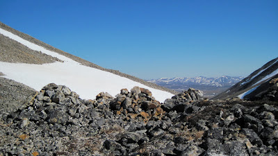
K. Inuksuk Pass (American-Right Fork) Interesting set of manmade rock piles.
(above) Pk. 3850+. This mini-massif may be the fifth highest independent summit in the Kigs, depending on how you define "independent summit"— (My unofficial list: 1. Mt. Osborn (4704) 2. Osborn's northwestern neighbor, Pk. 3998 3.
Grand Singatook (Pk. 3870) and 4.
Kayuqtuq (Pk. 4000+ ?) Peakbagging the summit in the above picture was my primary objective this Canyon Creek trip, but Pk. 3300+ up canyon seemed like a nicer place to be, so we camped there.
(below) Gneiss towers on the southeast shoulder of Pk. 3850+. The wall in this picture has, on very rare occasions from certain summits, flitted into my frame of perspective through lined-up corridors of mountain, but its exact location remained hidden in the geologic folds until this trip, when Rick and I turned a corner on Canyon Creek to discover its true location.

The NO-SKETCH PARTNER LAW is stated thusly: the scope of your climbing ambitions must conform to the mean climbing ambitions of the group.
What this means is, you can't be an asshole. We've all had that kind of Comstockian partner who is ready at a moment's notice to bail from the corniced ridge on which you both are standing. Some alpinists have no natural ability to execute the crucial task of NON-CLIMBING when the conditions permit, and these are the ones who seem strange and extremely self-centered within a group in, or going to, the mountains. Such a climber cannot hang except with those of their own kind. It takes great effort.
On Friday, 3SA, as Rick and I were packing for our weekend trip into Canyon Creek, I saw a post on Supertopo by a friend of mine: Jabber's thread on Supertopo .
He was bailed on by a mancrushed partner! Huge arrangements had been made and dates precisely calibrated for the two of them to escape the GLUE OF FAIRBANKS, but at the last minute, the guy goes "off with Bridwell" to some other mountain. Clearly, a violation of the NO-SKETCH PARTNER LAW.
(above) Rick Anderson at the "Snow-machine Pass into upper Canyon Creek," looking south. (The one labelled "A" on the map. Gneiss unclimbed tor in background!
(below) Upper Canyon Creek from Pk. 3300+, looking southeast. The Snow-machine Pass is at center of photo.
I was psyched! A friend to go to the mountains with! And a fellow Kigluaik lover who's been all over these hills on foot and by dog team. It's so much fun doing trips with Rick because we can sit around like long-lost brothers discussing extremely obscure minutia of hill and valley, and never grow bored with it.
But first we had to escape the GLUE OF TOWN. Over many weeks of winter, the GLUE OF TOWN had gotten Rick pasted down like a victim from the movie Alien, but I was certain the lure of a trip to the Kigs in perfect April weather would loosen the bonds of the slimy substance that coated him. I offered him my best old mount, Crusteo, the Polaris .340. The GLUE began to loosen. We hacked at it with our machetes, carving away excuses, harboring sleep throughout the weekdays, patiently unraveling obstacles. My wife Kristine, who possesses the magic power to either dissolve or intensify the GLUE with the slightest look, was blowing in our favor; someday soon Kristine and I will wage our own war on the GLUE and escape together, but for this weekend it was Rick and I, and I was mighty glad of it, someone experienced with whom to share the adventure.
(below) Rick power lounging at Canyon Creek basecamp, base of Pk. 3300+.
(below) Pk. 3300+ from south. This photo was taken in June 2011. Rick, note the fresh, cataclysmic landslide in that gully we were hanging out in behind camp— Is that why I felt creepy in there?
(below left and below right) Inuksuk. I found these homunculi on a
previous reconnaissance to Canyon Creek, at the pass marked "K" in the map above. I know nothing about how they got here, only that it looked like a likely place to herd reindeer into a ravine.
Solitude is jagged and hard, a bare floor. All it takes is another mind in a lonely valley to warm the place up, no matter how cold the temperatures, no matter how far from town you might lie. So enormous is the contrast between a trip into the Kigs with friends, and a trip to the Kigs with no one, that my brain cannot even grasp the disparity; they are two different mental modes, the one primitive and speechless, the other easy and confident. Both are necessary for wisdom, I cannot turn my back on either. But it is very hard to fight the GLUE alone. I am deeply grateful for the friends I have found, for the times we have had huddling in the wind and surreal beauty.
(below) The Grand Singatook (Pk. 3870) from the north. Nils Hahn and I had a great trip here sometime in a June of the 2000s. We came from the Teller Road seeking the ultimate Nordwand of the Kigluaik on the back side of the Singatook: instead we found a two-thousand foot snow-slope capped by two or three pitches of easy Scottish-gully ice. Why are my climbs always skiable?


 The greatest excitement occurred during the snow-machine phase, of course, the most dangerous segment of any trip, when, unbeknownst to my own awareness, I executed the most prodigious jump ever accomplished by myself on my snow-machine (the redoubtable Bearcat, Super Smooth Andy G.) when, purely by accident, I launched off a bare tussock at high speed and sailed 16 feet over a creek. Leonard, following my tracks, wasn't as lucky... his front end went into the creek and he over the handlebars, his face smashed in the process.

 With the attainment of this high point, all of my dreams and ambitions had been realized. Buddha-hood, achieved. Ego/Id structure, momentarily stabilized. My self-identity was no longer in doubt for I had become nothing. There lay the Kigs in the near distance to the north. The GLUE TENDRILS simply vaporized into wisps that dissipated in the clear, cold air.


