Saturday, May 22, 2010

Singatook- Gregg Stoddard Memorial Springtime Yahoo Field Trip to 3870, year 2010

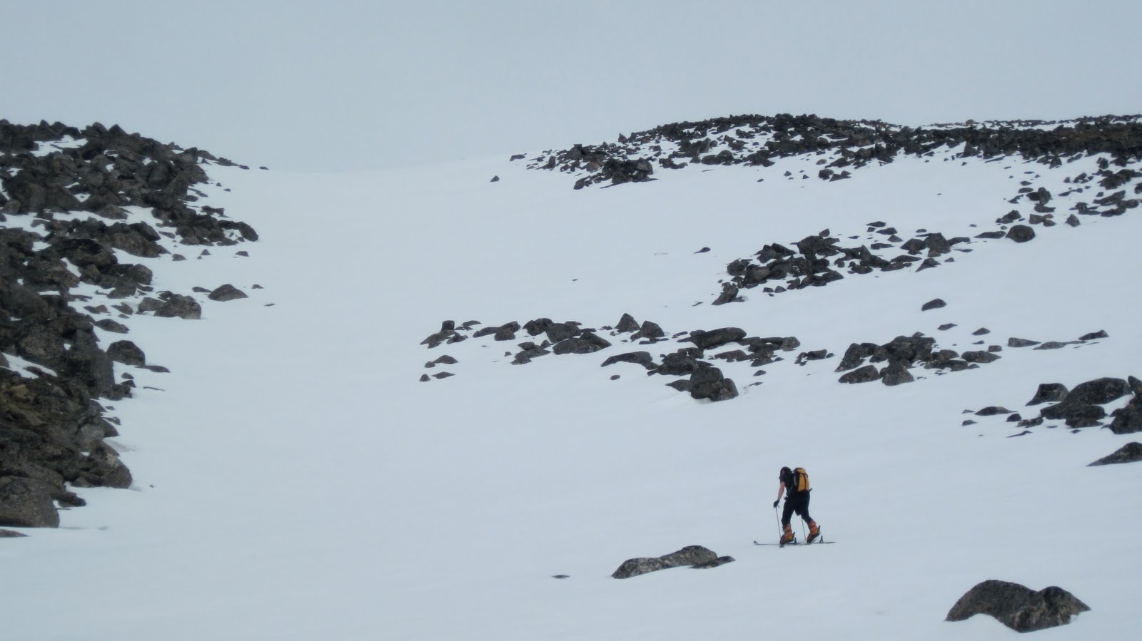
(below) View from top of Solar sidewalk at 3200 level, looking south down the upper part of Singtook.  Woolley Lagoon indiscernible in distance. Keith Conger about to drop off the edge in search of dropped gear.   

MAY 09, 2010:  GREG STODDARD MEMORIAL SPRINGTIME YAHOO FIELD TRIP TO 3870 was a great success!  Keith and Ian summited the Singtook once again to commemorate the man who brought us together as friends so many years ago, the arch telly fiend, Stoddard.  Though he left Nome for the big city, the spirit of our original trip propagates forward, compelling us each spring to make the pilgrimmage to the sacred mountain.    

 (below) Singatook from the Teller Road, 17 miles distant.  Singtuq?  Sinughaiq? Sinaillaq? Somebody help me!  How do you say it?  Leave comments...  Francis Alvanna says "Sing-took!" kind of like that, so that's what I'm going with.  It is almost universally referred to by the people of Nome as "3870".  

The Singtook... the Mt. Washington of the Seward Peninsula... possibly the most climbed peak in the Kigluaiks...  receives the full brunt of any weather coming in from southwest...  like any mountain invested with mental process by interaction with humans, the Singtook is a type of psychic private property..  people have lived at Woolley Lagoon for a long time, climbers must choose their spiritual windows with care, or otherwise are required to show their asshole license...  hence, our permit for the Greg Stoddard SpringtimeYahoo Field trip to 3870...

(below)  Keith Conger at the start of the Solar Sidewalk, the classic ski tour up and down the Singatook, usually of four or five hours duration.  A fine Greg Stoddard lies ahead.

(above)  Keith skinning up the via media part of the Solar Sidewalk...this is the fun part on the way down, a black diamond due to the potential for smashbody on the perfect Cretaceous granite.

(below) Via alta part of Sidewalk, summit hump of 3870 in background.  On other Greg Stoddards, Keith, who can be a mighty sick huckster,  has hucked the center of that face in the background.  On the 2010 Stoddard trip he launched from the saddle to the right of summit, while I crept to a blue square lower down. 

(above)  LOVE these hills!...   'v lost count of how many times i been (sic) on this summit...  probably equal to the number of times 'v failed to reach this summit!


(below) Apres ski...    we didn't get any good pictures of the descent because of it was ALL ACTION!  Like any good Greg Stoddard, we skied right up to the car.
    If you go to the Singtook, it's good to sort of ask permission of the mountain, and maybe the locals too, if you can park your car on the Teller Road.  I'm not really sure what I'm talking about, but it seems like wise advice for anywhere you go.

   Farewell, GREG STODDARD MEMORIAL YAHOO FIELD TRIP TO 3870, year 2010.  So this was our yearly pilgrimmage to a sacred mountain. It's always nice to bag the summit. Have you ever seen it wreathed in lenticulars?  Monsters!   Greg Stoddard is probably batting about 50% when it comes to reaching the summit.  I believe this year makes two or three in a row.

     Skiing is so louche, so hedonistic—  I mean, anyone can go WITH gravity.  That is why I state, Stoddard is a fiend, the arch demon of telemarks.

   It is time to return to the fight UPWARDS against earth's gravity.

Windmills, Sunset, Pennies, midnight sun bouldering

   River Lethe bouldering under the midnight sun on work days,
for days and days, for what seems like weeks and weeks
(the days are bright/and filled with pain
enclose me in your gentle rain)

  Metamorphic nightmare leaning choss piles with sky ladders of big jugs
(I've spent years gradually testing them)
 climb smoothly though,
it's never pleasant dangling supine under tons of meta-sedimentary,
this is playing with guns that are loaded,
this is some very brittle bones

I shall climb in the Kiguaik no more
there is no need of venturing up the Kougarak Road
we can wonder here, by the sea, amongst these outcrop gardens
befuddled with the lotus fruit of crack and crimp, air and dangle,

finch, longspur, sparrow, wren,
(the home team, the ravens and ptarmigan,
 trying to protest their rights for staying the winter)
entire landscape humming in and out, oscillation

the day of pain and yawning drops out of sight,
here is the hole, hole, thumbs down, jug, jug, dangle that requires all of your attention
here is a mantle onto a glued flake
here is the best damn boulder problem you ever expected
down in the thrustle of chirp, reep, whoo-oo--oo, keep, keep

chi is oozing out the pores of the earth into the pores of my skin

i have forgotten all about the silent peaks
summits still encrusted with snow
repulsing every attempt

wonder here, for now, by the sea, pulling down,
soon it will be morning and the streams of humans will begin...

Thursday, May 13, 2010

Inuruq (Pk. 1926)

(below)  Journalist and ski ace Tyler Rhodes descending into Tolkienesque murk, two Sundays ago, north slopes of"Inuruq" Mountain.    He got lacerations in his P-Tex.  Crater Creek and Pilgrim River lurk in the mist.
          Here's an analogy that might make sense to any Supertopian:  Supertopo   Salmon Lake is to the Kigluaik Mountains, as Bishop is to the Sierras.  It's a horrifying analogy if you really think about it.  Salmon Lake is on the road, you see, the Kougarak Road, and so may have involuntarily invited just such a fate, looking one trans-Siberian highway forward in time... 
      
         This blog takes responsibility for crimes against the Earth.  This reportage of climbs is nothing more than another unit of encroachment upon the wilderness.  Just by posting Tyler in front of this grey curtain, I have destroyed the pristine wilderness veiled behind it.  These were unknown places;  now there exists a little more known... 
       And why these crimes, what justification for a Kigsblog?   Let us be honest, brothers and sisters:  Ego, and the mammalian need for recognition.  A European craving for exploration, and the bringing home of another conquered wilderness to the homeboys at the Explorers Club in the father land.  The same reason there sits a bust of Amundsen on Front Street.  Coupled with an inability to stop the thing because it's actually SO MUCH FUN doing it, so WRITE ON!!..

        But another reason to blog, perhaps, is to preserve worthy languages.  When I asked Earp (...Earp's Salmon Lake cabin is to me, what Glacier House was to Norman Clyde...) what was the name of the funny, little, incongruous mountain at the north end of Salmon Lake?, she replied: "Inuruq."

(below) Inuruq. The map is not the territory.

     I asked Marie Saclamana, who teaches Inupiaq in the classroom next to Mr. McRae's 4th grade, how she would translate "inuruq."   This kind of question can be super tough;  it's a bit like transferring a file from an Apple to a PC. 
    I had figured the word—  inuruq—  was constructed out of the Inupiaq noun and suffix combo:

inuq (person)    +   tuq (he, she, or it is doing) =  inuruq

    What Marie forced up (translation works using approximations...)  "person who has had an accident." This actually makes a whole lot of sense, if you know this mountain—  it has a conspicuous landslide on the front (north) face, a real MASSIVE one, which, rumor has it, was witnessed by people from Salmon Lake sometime in the last century.  Inuruq looks like a little person who has vomited away the front part of their torso, and held the whole load in cupped hands around their waist level.  You can see it across Salmon Lake from Interstate 395... I mean, er, the Kougarak Road....

Someone undoubtedly knows much more about this mountain's name than I have come up with here.  The Todd party reported the mountain's name as Coho in an edition of Scree.  Please comment.  One problem with blogging that keeps jamming my foot a little further into my mouth, is that I keep writing about things which I have only partially researched.  But if one waits until the research is complete, one would never post!  Is is supposed to be Inuraq?
(above) Not an image of Inuruq-  rather, this is another hill off the Kougarak Road further south showing the avalanche conditions of 3 Sundays ago.  The crown face on the left, foreground hill is probably 800 ft. wide and 1 meter deep. If you search closer, there are other slides.

A question that has long plagued me:  is there real avalanche danger on the Seward Peninsula, or am I just over-paranoid?  The day Tyler and I tried to ski Inuruq was grey and rainy.  The summit was sheathed in spring blizzard which we were unwilling to penetrate.  Worst of all, the AVALANCHE PARANOIA light was lit on our mental dashboards as we kept encountering sketchy-feeling snowpack in the deposition zones, as well as recent slides, plus rain, and warmth.  It was reassuring for me to see that Tyler was not without paranoia.   We eventually took off skis and began booting up the bare tundra of the northeast ridgeline, before getting shut down.   Back to the machines, back to the truck and trailer at Nugget Pass, back to town, grind, sleep deficit,  paperwork, kitty litter, and kids, the flow of kids, pushing like ocean at the bulwarks....

Tuesday, April 27, 2010

Topkok in early Spring

 if anyone is offended by the sharing of these secrets, please leave comments and i will discontinue this entire silliness immediately...

         the ishigak darted by, mounted on a little child's snow machine...  i was sitting in the sullen gloom of the Topkok shelter cabin two Sundays ago staring out the lighted frame of the window when i saw the ishigak go by, but only for a second...  as you can see from the picture of the shelter cabin (below, left), there was little snow that day, the temperature being far too warm for ice climbing, which was what i had come for (but at least the Iditarod Trail had hung in there— silky smooth sailing on snow machine, as a matter of fact, due to the miraculous meter of snowfall in mid-April)...   i ran outside the cabin to view the ishigak, but the little man had disappeared, no sound, no trace, no lingering exhaust...


        later, leaving the hut, i walked east for two or three miles down the beach, under the exfoliating cliffs...  the First Weep was non-existent, and the Second Weep, (top, looking east, with Tapkak Head in the setting sun) which Collins and I had epicked out on the year before, was a shaky-looking thing that did not inspire confidence
           it was warm in April, the tors in the distance poked out of emergent tundra like the cover of a Yes album,  but PARANOIA overtook me like a squall whenever I walked out into the open... Topkok had become like a mental illness to me...   i mean, just look at Phil and Ryan's spring Topkok story fro last year!

http://nomemisadventures.blogspot.com/2009/05/excellent-bear-tacular-madventure.html

why is Topkok so weird?  i think it's the quality of the wind, all circular and eddy-like and going-every-which way like the Z-waves on a cartoon TV screen... this must be due to some odd confluence of air masses...  if anybody understands the winds of Tapkak, please leave comments...  but really, the deal is, the place is a psychic node, a crackling network point for the Earth's psycho-electromagnetism....
(above)  February 2009 iteration of Topkok 2nd Weep, Ian climbing, 30 below... 
(below) the same climb two Sundays ago, April 18, 2010, with hanging bells, like a Hung Jury of Nome...  Ian was too damn chicken to solo the whole thing...
Here was a new one, not present in 2009:  it could only be the 1.5 Weep (above)...  I was scared even to touch it, with the birds singing in the air and the temps so warm...  this was a great personal failing, a complete let down of will and power, a sin, the sin of CLIMBING NOT...    nevertheless, these types of chicken-outs have a way of preserving oneself, so one can remain whole to climb the 1.5 Weep on another day, KOW, KOW...
 Normally, the First Weep  is a fun 60 foot solo on water ice (WI-1 or WI-2), but Spring had already melted it by two Sundays ago (above)...  the beta is, you climb the falls, then continue up steep willows and solo the south arete of the Ishigak, visible in the background as the lefthand skyline of the 100 ft. outcrop... there's good THWACKS on turf and hooks of frozen flake (M-1 or M-2) with at least the illusion of exposure, pretty good for all the trouble getting there, and the ocean gently tugs on your earlobes as you climb...

   this was the trip where i felt the rock of Tapkak for the first time, warm under the fingers...  always in the past the feel of the rock had only been transmitted to nervous system by the feel of the tools, the chrome molly and carbon fiber shaft,  always in the past you couldn't take your gloves off, so cold, so inhumanly unworldly ALLAPA!

   but now it was April,  the quartzite had hatched from its icy pupa...  i discovered ("discovered" only for myself, of course, all this data has been known by people for milleniums since before the whole bluff rose out of the sea for the second time, somewhere in the Pliocene) that the choss quality was highly variable...  in places, like in the picture (above), the degree of choss approached actual decent rock, almost so good that a drilled hole with a bolt in it might actually hold something, which is rare for the Seward Peninsula...  in the second zawn from the hut,  i bouldered in Scarpa Inviernos on beach boulders where the quartzite was gray and dimpled, and the cracks were true cracks and would have taken nuts marvelously...  elsewhere, the rockfall was so bad, it was like the Eiger Sanction, i huddled under that very bottom inside angle of the overhanging sea cliff where the rocks can't technically get you, scuttled along with  feet pressed right up against the cliff where the sea ice met the rock,  climbing the choice bits, lost in rock and turf and ice and thought, don't go there, they all say, don't go there, but of blogging, who can really say?

(Below) is a map of phoneme/land correspondences from the Norton Sound coast that have been propagated for some time...   I've had this map floating in my school files for a long time, but have no idea where it came from, or who made it.  Leave comments if you know.  And i do understand that climbing, and worse, spraying about a magical place, before you have actually done the research of the land stewardship is a rude and reckless act not to be condoned, but shouldn't these particular words be posted, do they not justify the desecration of the post?  

                                                
http://www.paulcolor.com/index.php#mi=2&pt=1&pi=10000&s=16&p=5&a=0&at=0

Foxy Peak

 (above)  There now, do you see it?  The real Fox (Kayuqtuq), hiding in the background.  Duh.  You might also notice the two route attempts on the decoy mountain standing in front of it, the foreground mountain which is pretending to be the higher one.  To think that I fell for this old trick ONCE AGAIN.  It's a standard trick of mountains everywhere, stand closer to the valley and you will appear to be taller than the mountains behind you.  The one in the back is the true high point of the region (as I've mentioned, one of the few possible "Four Thousanders" of the Kigluaik).  Now I've spent gallons of gas and layers of capillaries to climb this peak, and it wasn't even the right one!  Shall I self-flagellate over this nincompoop fiasco of wasted gasoline and hardened capillary?  Or shall I zen it out and simply state:  that's how it goes in the Kigs...

Back on the March attempt, Earp had been referring to the mountain as "Foxy," which I will do for this post, which sort of differentiates it from the true and highest Fox, which is different than when I was calling "Kayuqtuq" in an earlier post, all the better since mountains do and should have more than one name.
     (above) This is what stopped me on attempt #2 yesterday— a brazen summit pyramid of gneiss where an easy snow slope should have been.  I am no Francois Marsigny, I carried no rope, a child awaited in Nome, I was pledged to be conservative, boldness has been slowly leached from my psyche from too long a sojourn in the fleshpots of Nome...  plus, a host of sub-excuses... I retreated.  No first ascent, just another new bail.

      Both attempts employed a northern approach from the Crater Creek side. (Below) is an image looking off to the west from Foxy showing why I couldn't just traverse around left to the rounded south side.  Osborn, King of the Kigs, is the meta-sedimentary lump furthest to the right.  The intermediary lumps are the Grand Central Peaks around Gold Run Creek.  Kigluaik peaks, in general, are lumps from the south,  but Gustave Dore' nightmares from the north. 
This late April Sunday was a day of days, an all-time day, the miraculous snowfall had rendered the mountains smooth as silk, a meter thick blanket of equi-temperature aniu, you felt your boots not far from the terra firma of tundra and talus thus alleviating the avalanche fear, a light breeze kicked up lines of spindrift which caught the sunlight, convection fog from the Imruk Basin wreathed the lower peaklets in  white coiffure, chi oozed up from every pore of the mountains that day...

(below) Looking up the ridge.  Took me a long time to trust the snow, so I stuck to the crest.  It's probably only Class 3.  A few fun moves on turf with fine thwack!s.


The thing to realize here is that although the climbing was easy, everything was shrouded in fear on account of being so far from town ALONE.  Not exactly "you're gonna die" fear, rather, "you might have a humongous hassle" fear.  Maybe I'm paranoid, but the sky seems to weigh heavily when you're the only one under it.  At these moments, your machine morphs into a sentient being, and YOU LOVE YOUR SNOW MACHINE.  And I do love my Arctic Cat .570 Bearcat.  (above)  Here it is waiting like a loyal horse, with C-Togs 3, 4, and 5 in the background.

Friday, April 16, 2010

Mud Mounds—part I

(below)  Same tooth, interestingly (the photo of Raina is reversed, I think.)  Her's went to the Tooth Fairy a couple of weeks ago.  Mine splintered into several pieces and fell into the snow last night at the Anvil mud mounds.   Both incidents occured within a two-week range;  this might, I think, qualify this dental coincidence as a 1.0 on the Synchronicity Scale, but that may be an exxageration.  
accident analysis:  the temperature had cooled down dramatically to about five above, so the mud had hardened since my glorious day in the Anvil mounds the previous Sunday (trespassing horribly, for which i confess and apologize)...  chisel was dull, penetration shallow...  as soon as I applied weight, left tool popped out... the apex of that cool Black Diamond adze (the triangular one that you can torque in so many different ways) slammed lower left incisor.     

synchronicity analysis:  periodic frequency of zone 2 physical injuries one every three years, on average,
to be noted that for Raina, this was no zone 2, merely the first tooth for the Fairy,
which may lower the synchronicity rating, but still, can we not call this coincidence at least a 1.0?

(and did i mention it was cold?  Lord God it was allapa!  Springtime in Alaska and it's Forty Below!  Wind blustering through at twenty to twenty five, spindrift spindrifting, Mikey and me blogganeering through sting and lash and frozen blood clumps, Left Hand of Darkness cold!  Allaparunga!  CLEM!!  CLEM!!!)

Tuesday, April 13, 2010

On Bouldering

   (below) Cabin Rock Crags (not Cabin Rock itself) in rime.  Drive up Teller to Cabin Rock (extremely disappointing in and of itself for bouldering potential), slog up hillside over a 1000 ft. to east, walk over the crest to scruffy hillside boulders and crags up to 40 ft. high, overlooking Penny River.  Land stewardship unknown to me at this time, but please leave comments if appropriate.
    Bouldering is the interstitial glue connecting the all too infrequent occurence of significant climbs in the Kigs.  In between the failures to get out of town, the failures with partners, the #%#@*&$$ snow-machine incidents, lies the wonderful bouldering experiences.
    What may not be realized is the miraculous access here in (region to remain unnamed for now) for BOULDERING, medium to low quality, but gloriously free, so many lost ridgelines with tors of metamorphic rock poking out of the top like vertebrae.

(below)  Sunset Boulders, Beginners Wall, Tuft Route.  Head out Teller Road to berry fields before you get to Penny, you see a crooked orange crag a short hike up the hillside to the right (north) of road.  Cool little M1 or 2 on exfoliated turf tufts.  Land stewardship unknown to me at this time, but please leave comments if appropriate.

Bouldering doesn't seem to sustain everyone.  Bouldering feels at times like reading fantasy or science fiction.  You creep out there and pretend you are really climbing.  You perch on little footholds a foot off the deck and imagine that those bryophytes under your heel are really the tops of trees in Yosemite.   Then you find a little turf mattress out of the wind and take a little nap listening to the wind howling over the top of the rock....

(below) Sunset Boulders, Orange Wall, Ian experimenting with figure-4 unsuccessfully. He is worried the metamorphic schist flake will catastrophically disengage.  Many of the local  bouldering gardens have a featured orange wall.  I don't know the name of the lichen.  Please leave comments if you know the classification of this orange species of lichen.  If you feel I have broached some common law by climbing on this formation, or especially if you have ethical problems with the spraying of geographical locations on a blog, you simply must leave comments stating your reasons, so that this entire blogging enterprise may be discontinued.  Thank you....
What were bouldering a social event?
Then I'd have arms a praying
And raising in supplication
And on their lips they'd be spraying
Of all the routes they would steal
We'd all have to get out on Friday
Right when the day is done
But bouldering ain't a social event
And I'm out here all alone... 

(below) Cabin Rock Crags-  M-bouldering paradise.  Made it up there one good day so far in February.  The ice in this picture is not the glaze ice I have referred to elsewhere as the "shellac";  in this picture we have rime.  It wouldn't hold your weight, but it came pretty close.  What caused the riming?  Wind.  Did I mention it was cold?
The last thing to comment "On Bouldering" is the Four-Seasonality of bouldering around Sitnasuaq. The summer bouldering can be fine at a time;  the winter bouldering can be superb when it ain't brrr.  The winter bouldering is the best.  Crunchy little torquing puzzles, moss, moss, cam, hook, lieback flake, ADZ!  Keep your heels down when you top out.  Fox!  Fox!  Cease bouldering and check for rabies?

Rocky Mountain Bluff.  Drive out Kougarak, before you get to Dorothy you pass a large foothill (Pk. 2374) on your right (east).  Could it be "Rocky Mountain" that rises above Rocky Mountain Creek?  (Leave comments if you know.)   A hundred foot bluff (1231) is visible.  Wouldn't touch it in the summer, but in the frozen Fall it becomes pickly-stickly and mossy-chossy.  In the picture is Earp in blue puffy soloing up the crumbling hideo-choss in some Fall of the later '00s.  Land stewardship unknown to me at this time, but please leave comments if appropriate.


none of this bouldering is of the least bit of importance, it is so far below V grade it is HIKING, but there is a reason that Alex Lowe's quotation has endured:  "The best climber in the world is the one having the most fun."  

Tuesday, April 6, 2010

Topkok Ice

       Tyler Rhodes took this aerial photo (below) a few weeks ago during Iditarod (March 2010).   It's a section of sea cliffs on the Norton Sound coast about 60 miles east of Nome down the Iditarod Trail, called Topkok.  The mass of ice in the photo I call the "Second Weep."  I was supposed to go there last Sunday but woke up too hungover and sleep-deprived to make the journey.  So what follows is a summation of 3 climbing trips to this spiritually-charged region that occurred the previous winter (2009), during which I managed to climb the WI 3 mass of ice in the photo.  These trips were not without adventure.  I don't know whether this was a first ascent or not;  if you have climbed the ice in this photo, could you please leave a comment?  
                     
       There is a huge need to be vague here.  These are sacred lands.  I am just an obnoxious climber/blogger driven by my own post-European ego to report about the climbing I did there.  I don't pretend to be blogging about Topkok for any other reason than to prop up my own faltering sense of self worth and insecurity-driven need for recognition.  The roots of this place go deep into the Earth, and it is an obvious ethical transgression to be speaking of it, much less posting pictures of it on the Internet.  I am sorry to be succumbing to this ridiculous need to TALK about climbing Topkok.  One should just climb Topkok and shut up about it.....


       Allapa on the Second Weep (above and below).  We're looking at one pitch of WI 3 here, fat and casual, except that the ice was exceptionally dinner-platey due to the fabulously cold temperatures.  This ice lies about 4 miles from the Topkok Shelter Cabin.  We walked, though if the sea ice is solidly accreted, one could drive.  Along the way we soloed a lesser falls, the "First Weep," which lies about two miles from the cabin.
       Did I mention it was cold?  Yes, I'm sure I did already, butOMG, you have no idea, really.  Look at the puffiness of my coat in these photos.  Below zero.  Way, way below zero.  It is fatally, horrendously, unimaginably cold in this photo, Antarctica, zero Kelvin, deep space nine,  allapa, allapa, move or freeze, lordy, sure is cold, what more is there to say? 
                      
       Trip number one was in January.  Collins and I made an initial reconnaissance of the cliffs and soloed the First Weep (of which I have no pictures;  it ain't much, WI 1), and walked far enough east down the beach to discover the Second Weep, for which we had no time.  One interesting thing was this amazing coating of verglas on the beach boulders:  about 8 inches of wonderful marine ice that made for really fun bouldering (below).  When we got back to the machines, Collins' Ski-Doo wouldn't start and we had a total and complete epic;  as he pulled his cord hundreds of times, I watched Jeff's spirit gradually get sucked away into his machine like a drunk's spirit getting sucked into any emptying whiskey bottle.  If the Topkok cabin had not been there, we might not have made it, that's how cold it was.   Yessir, sure was cold, yep.... 

                          
       The second trip (February?) we climbed the main business, the Second Weep.  This was absolutely the coldest of the 3 trips, the kind of cold that can kill you fast, 25 below at least with a stiff breeze.  Collins belayed in his puffy coat and had to eskimo dance vigorously to keep from dying.  I put in screw anchors at the top and yo-yoed back down on my 120 meter Sterling Duetto so Jeff could follow the pitch.  On this, his first real ice climb, he was clinging to the last steep part and overgripping his tools, when I heard:

       "I'm going to pass out now..."

       "NO!  You can't pass out now!  Get your weight onto this rope NOW!"

       You see, if he passed out before weighting the rope, I wasn't going to be able to lower him due to friction in the system, and if he was going to pass out up at the top of the pitch, I wasn't going to be able to get up there and rescue him before we were both become popsicles.  It was cold, you see, allapa, deadly cold, I'm not kidding.  We managed to get Jeff lowered off the climb and pull the ropes and get out of there, leaving the two screws at the top.  All in all, Jeff hung super tough for this baptism by fire and ice;  there are kinder ways to be introduced to ice climbing than a 14 hour Topkok trip.
       The third trip I did to Topkok was solo.  I spent the day bouldering around.  I saw numerous turf climbing lines waiting to be ascended.  If Topkok were the Seward Highway instead of the Seward Peninsula it would have lots of killer turf lines, but it's not, thankfully.  The rock presents a real hodgepodge of geologies, quartzite seeming to be the predominant blend, mega-choss, of course, like every other piece of rock on the Peninsula.  Miles upon miles of sea cliffs stretch away down the coast, haunted by Ishigaitch, the little people, though I have never seen one.  Topkok is just a spooky place.  The shelter cabin is another of those terrestrial acupuncture nodes, a surreal portal into other dimensions like the wardrobe in the Narnia books.  
   Before making the ride to Topkok from Nome, you have to learn about the "Blow Hole," which is this crazy wind funnel between Topkok Head and Solomon.  The Blow Hole is why the shelter cabin is there in the first place.   If the weather report says "high winds between Nome and Golovin," you have good reason to fear. 

Friday, March 26, 2010

Thompson Creek- Maniilaq Falls

Town was a glue, a terrible glue.  It sucked at our feet like muskeg and threatened to prevent our leaving.  Nome had turned into Sodom and Gomorrah due to Iditarod.  So we tore ourselves away and headed back up the Kougarak Road late on a Wednesday night, back into the white mountains.


Maniilaq Falls (WI 2)  in Thompson Creek was about a pitch long.  It felt odd to be whacking into actual BLUE ice in the Kigs in winter;  usually these cold mountains are able to produce only alpine ice.  Our waterfall must be fed by a little tarn above it. 


There was a disturbing hole at the top of the falls in which we belayed, the obvious source of the frightening detritus we had seen at the bottom.  You can see the hanging crown face of whatever bizarre thing it was that released in the picture, below.  


Thompson Creek is a cool little cwm walled off by the north face of "False Tigaraha," an area where the pluton comes into contact with the schist;  Maniilaq was our mysterious name bestowed upon the blob we climbed on the east wall of Thompson Creek.  Many new ice blobs have been sighted this winter due to low snowfall.     

out of the cone of Hells Angel roaring
into the silence of the whackety whack and wind
 how temporary your hair in this temple of nothing
so precious your mud flows for only now
i don't want anything to move
nothing in this place must change
i tip-toe around the frowns on all your faces
we are all become the prophet on the stick
he said to make hot water bottles before you go
don't go back to town, you are not wanted there
and this is how every snow-machine mountaineering trip must end


Monday, March 22, 2010

Kayuqtuq North Face

  
  (left) Earp on easy mixed at 30 below, an NB (new bail) on unnamed peak located on divide between Crater Creek and Fox Creek (for fancy's sake I refer to it here as Kayuqtuq), Monday of Iditarod week.  We turned around a pitch below the summit having done perhaps 1700 ft. of Class 4/5 snow and gneiss climbing— the crap gneiss, the brown, bloody stool-colored stuff.  In background of photo you can see the formations referred to elsewhere in this blog, also fancifully, as the "C-Togs."      


I was relieved to see consternation on the normally fearless Earp's face as we dismounted our machines (my new Bearcat and the redoubtable Polaris, Crusteo.)  It confirmed what I have never been able to verify but always felt:  that it's scarier than hell to be alone up a lonely valley in the high Kigs at 40 below.  I always harbor secret terror just to be there in the deep water...

(above)  Kayuqtuq (Pk. 4,000+) may qualify as one of the rare "Four Thousanders" of the Kigs.  Kayuqtuq means "Fox" (Vulpes Vulpes).


Crunchy stabby, dagger-and-go, dagger-and-go...  we certainly would have soloed but the slabs looked so loaded man, well hung and snow-white tan, so we hassled the rope between us, which slowed us horribly.  Beautiful, arighaa, bon, bon, but did I mention it was cold?  Yes, it most certainly was, sure is cold, yessir, man!, allapa!, F-word!


(above)  Pk. 3050+, south wall of Crater Creek on the drive in;  Crater Creek is a sort of parallel analogue to Grand Central Valley 10 miles south.  The peak in this photo appears to be a sort of translation of Grand Central's Crater Lake Mountain (Pk. 3147), very confusing since Crater Lake ain't at Crater Creek.  

(above)  The Third C-Tog (Pk. 2650+)   
       Definitely uncomfortable with the naming of things.  These are not the real names.  The names on this blog are just little contrivances my brain has had to come up to cope with the hours of slogging in solitude in the Kigs.  
     What do you do when you have come to know a geological feature as a distinct entity?  You're dangling from the thing all day, admiring its form, power-lounging on its tundra ledges, admiring the view, and, at times, talking to the thing, talking to stone itself—  at some point you invent a little cognomen to apply to this geological formation so that you might refer to it succinctly in your self conversations.  So the names in this blog in many cases are just widgets of one guy's brain and not meant to be taken seriously.    (BTW people, it was not Stan's fault that the spire in the Arrigetch got called Justice Spire.  He only climbed it...)  So, why continue something sure to offend?  Because it's just too much fun!  The Kigs are a landscape right out of an Ursula Leguin novel....
       If you know the true name of the mountain, please comment...

Descent.  
              Often, the scarlet "L" burns on my forehead, and I doubt our decision to bail from Kayuqtuq.  Other times I trust that our intuitive apparatus was working correctly at the time, that some hurt or extra suffering lay in wait among the folds of potentiality surrounding the last pitches to the summit.  Endless vacillation between these two poles. 
        For me at least, the vacillations have tended to settle upon the former pole, the Pole of Total Loserdom.  Those last moves WOULD HAVE BEEN glorious.  It was ONLY —35° F (with the wind at 20 knots and increasing as we neared the somewhat).  We bailed at the rock bands that guard the summit, 2 or 3 pitches more of casual mixed climbing.  Question marks lurked:  there was going to be frostbite....  I see a fearful sweaty little dad go scurrying back down to the security of his fuming machine.  
      Obviously, once again I was committing the logical error of equating my entire self worth with a moment's action.  Power is gushing from the breaches in my ego.  So last night I got out The Rock Warrior Way and began patching the patches of the patches so we can go up again next weekend.  Here's a link to Arno's site warriorsway.com