Wednesday, August 1, 2012

Tigaraha East

     Prior to the ascent of Slimedog (see previous post) three Saturdays ago, Phil and I slogged in to the Sinuk for a repeat of the "East Arete of the East Tig(II, 5.4, big Class 4 approach), the right-hand knuckle in the giant birdy-finger of Tigaraha as viewed from the south in the dead of winter when it's the only mountain not holding snow.  I don't think Phil and I could have achieved success in Crater Creek on the Slimedog (or "Greendog" as we are now calling it, being as the Slimedog is incomplete, having avoided the arete on pitch 1, see previous post) had we not gotten to know each other as climbers beforehand on Tigaraha, 7 Sundays previous.  East Tig seems the way more doable option in a weekend than the taller Grand Tig next door.  More Nomen-climbers should pay the price of one brutal hike to do this climb;  accordingly, I have reached into my brain for this post and clicked on Allow yourself to sound like a guidebook author.  


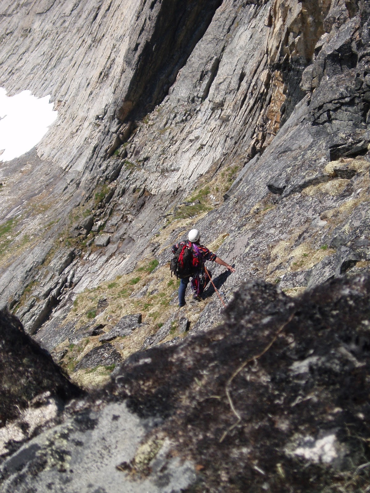
        (above) Phil Westcott on descent of "East Tig", June 2, 2012 ( 5 Saturdays Ago). Much of the route is visible beyond Phil.  The route follows a ramp system perched rather flutteringly over the impressive swoop of the north face of Tigaraha.  A 35 ft. chimney on the summit pitch is visible in the photo as a vertical black line rising out of a notch at the righthand edge of the photo.  In front of that is a rather exposed 5.4 slab.

  5SA The GLUE OF TOWN lay thick and sticky with the post-schoolyear pile-up of personal responsibilities.  The GLUE threw everything it could think of in my way, including, at the last minute, a failed, moose-blood dripping, refrigerator/freezer in my home.  In my blind frenzy to cut through the GLUE with the MACHETE OF SELFISHNESS to make my escape to the mountains, I committed many uncoolnesses;  wasted meat of moose incurred loss of karma points.  Thanks go out again to life-partner Kristine whose own nonentropy field counterbalances my own considerable disorder, and without whom no Kigsblog would be able to combine action with rave and spew.  
      Part of the urgency of the climbing window at the time 4SA was the dual presence of those two most rare commodities: good weather in the Kigs, and a motivated partner.  Phil Westcott was here for the Spring in the employ of the National Park Service and seemed to have the right set of rather off-beat qualifications to make a proper Kigsboy—  i.e., an individual who might see some sense in doing worthless climbs on small, toppling choss heaps with huge, torturous approaches.  We set the compass to STEELY FOCUS, hacked our way out through dense foliage composed of doubt, schedules, computers, parties, the GLUE, in short, to the mountains, where all was soon forgotten.


(above and left) Tigaraha from north.  The pitches are marked on the E. Tig to give a sense of scale. The best descent is to downclimb the route.   For greater kicks, from the summit of East Tig continue west along the spine of Tigaraha following the 2005 Peacock-McRae route (IV, 5.9)  MARK!, leg up, spin, leg up, can't find it, tail in the way, MARK!, spray some down there, ah, the easement upon the swollen bladder of Narcissus brings relief  the continuation of the East Arete to the Grand Tig, by downclimbing two pitches (these would be the West Ridge of East Tig, 2 pitches, 5. 3), then getting back up on the spine of the arete via an enlivening 5.9 pitch with a rotten overhang-- the rest is a sidewalk in the sky with great climbing up to 5.8 until you reach the summit of the Grand Tigaraha, whereupon downclimbing the 5.3 sky-friction slabs of the West Arete bring you to the West Notch between the Grand and West Tig.  This Notch, accessible by Class 3 slopes, would mark the starting point for the regular route on Grand Tigaraha, the West Arete, (II, 5.4).
    One may return to a basecamp in the Sinuk from the West Notch by heading back east across 4th class slabs that traverse under the 800 ft. south-facing wall Tigaraha, but it's a grovelfest, and treacherous when wet;  somewhat easier to contour around to the northwest of the West Tig, staying high, traversing across Class 3/4 terrain, to the conspicuous "Fab Four Tors," John, Paul, George, and Ringo, which, by the way, are all excellent one-pitch climbing tors little piss here, little piss there, whirl, lift, cancel, whirl, cancel, whirl, lift, little piss here, MARK!.  From the Fab Four Tors one may descend weary lengths of Class 3 talus slopes back to the Sinuk.
        There is a hidden "North Gully" that drops from the West Notch to the north providing potential quick access from the Sinuk to the Grand Tig.  Conditions are usually icy in this chasm, and huge hanging pianos chock the narrow walls.   Once I felt compelled to put in a screw for a self-belay on some weird ice in there;  another time I painfully rappelled North Gully in rock shoes with snow-bollard anchors.  Crampons advised.


(above) 800 ft. north face of East Tig, the Grand Tig in background.  A patchwork spectrum of metamorphized granite.

     Had a discussion this morning with Samuel Johnson on dreaded Facebook (no place for introverts)(link to Sam's blog alpineessence) about a possible climbing metric for assessing approaches;  I don't know if anyone has applied a term to the concept yet, so I would offer: "slog ratio."       
    The equation is stated:

number of miles to get to the base of the actual climbing ÷ 
number of pitches of actual climbing                       =  slog ratio

        For instance, on the East Tig, it takes 8 miles of slogging for 4 pitches of actual climbing, giving a ratio of 8:4, or 2.0—  a slog ratio which, Sammy and I agreed, is horrendously high, bordering on SILLY.  Anything over a slog ratio of 1.0, meaning a mile of slogging for each pitch, would feel silly for most climbers.   Even more damning for the slog ratio of the Tig (and the Kigs in general), an adjustment factor needs to be added to the numerator to account for the last half mile of Class 4 approach slabs, which are steep, loose, and treacherous, more like 4 or 5 miles of effort (with a packsack full of Camalots) than the half mile shown on the map. 
             
(above) Phil Westcott at the rope-up area for the East Tig climb, looking southeast.  Obviously Phil is impeded by his large camera which followers of Kigsblog wish I would carry instead of the paper cameras favored by men of action.  In our later climbings, Phil later had to stow his large camera after it came within one exhalation of rolling off a thousand-foot belay ledge.  
     This spot in the picture is reached from the Sinuk via Class 4 slabs that show a good, healthy "green quotient," meaning the talus is glued down by vegetation for good footing.  One can start slogging west up the hill at a prominent glacial erratic boulder that sits at the Sinuk headwaters;  many bouldering possibilities are available on the way up.  From this spot, one can descend directly west towards the West Notch for an assault on the Grand Tig, but one starts by downclimbing steep Class 4 slabs adjacent to a hideous chasm (Kigsterm for a gully filled with talus) and a rope might be warranted for those sheep unsteady on their hooves.

(below) Ian downclimbing from the East Tig roping-up area, heading west towards the Grand Tig. This image is taken by Mikey Lean from an earlier trip in 2002.
  Norman by that time had turned into a grumpy old mountaineer, regarded by many as sketchy.  Grey-stubble bearded, grumbling to himself, gear in tatters, the dogs of the village barked in protest from their chains.  The younger climbers were friendly, but few would go on a rope with him anymore, except for Jules, who had gone back to the city and his piano... 
     Many come to Nome saying they are climbers, but few keep climbing.   Few lie within the 0.02 percent of climbers who fit within the range of freakish qualifications that would allow them to actually enjoy the climbing on the Seward Peninsula, so they drift away from climbing after a time, with a degree of frostbite usually, and I am left with that familiar feeling of uncertainty as to whether the climbing in the Kigs is really climbing at all, nor daring to look in the mirror at the old mountaineer to gauge the actual degree of his sketchiness.  
      But really, it's the SLOG  RATIO that's causing the climber attrition.  You have to work so hard in the Kigs to get to the actual climbing.  Only a person living in their own fantasy world can continually fool themselves that dragging gear over tussocked ground in the cold and wet with little chance of ever using the gear on a real wall is a worthwhile and noble venture.  Has the global practice of climbing so far degraded as of 2012 that desperate climbers are finding it necessary to hike all the way back in to the back corners of the wilderness for a few stone smudges on a hillside?  What sort of masochist buys into this fantasy?

(below) Phil Westcott and Lucy at the roping-up area, facing south.
     Answer:  Phil.  Phil Westcott of the Westcott Brothers Band showed up in Nome on an SCA internship at Bering Land Bridge and actually sought out the sketch old mountaineer (thanks to flickr and Rick Anderson for the contact, see Phil's excellent photos on flickr), it seemed like a miracle:  here was a young man dropping out of the sky who said he wanted to go climbing the Kigs, had experience on multi-pitch choss from his time at Seneca Rocks in West Virginia, didn't mind a little backpacking, and didn't care a bit that he had no gear.  Furthermore, time would prove him a member of the freakish .02 percent of climbers who actually respond positively to HIGH SLOG RATIO-style mountaineering, even after his toenails fell off and he couldn't really walk for a week or two following.  He has that type of alchemical mind that can take a chunk of anaq (such as the prospect of a horrible slog through Spring posthole-snow with a heavy pack) and transform it into something gold, a mind that crops out unpleasantries, leaving only fun and beauty, so that the mind is tricked into returning again and again to the source of its pain and beauty. 

(above)  View from roping-up area of East Tig, facing southwest.  On the left is a beautiful peak, "Turncorner Mountain" (Pk. 3250+)--   Kristine McRae and I did a horrendous fifth-class schist route on one of the righthand ridges in the summer of 2001.  Lift leg, relax, relax  On the right is a mountain I am fond of calling "Falcon Killer Pk" (Pk. 2840+) due to an attempt on my life by a Peregrine as I was soloing the highest of the granitic tors, visible as a dark bump in the picture, a 5.6 thrillfest with a prodigious drop off the starboard bow.  Lift leg, nothing coming out...ah, there it is, MARK!  I was nowhere near the nest;  she leapt out from behind a granite turret from three feet away in a most murderous and calculated fashion as I was hanging from a hand traverse with no real footholds.  Had I not heard the click of her talons beforehand, I might have let go.
     A necessary skill is managing the GLUE of TOWN, a significant force built into causation that can hoist a trip with its own petard before it's ever left town, a type of causal gravity sucking one back into Nome even as one is trying to leave it. Phil proved he had the necessary focus, achieving escape velocity despite a few swirling, muddy eddies of communal torpor hanging like fog in the NPS Bunkhouse where he'd been staying. We slogged it to Hudson Creek Pass late on a Friday night; it was Solstice, mind you, time of day had become meaningless. Next morning developed sunny and fine, birds chirping, flowers resplendent, brooks babbling, breeze with no bugs. Phil, Lucy and I slogged it some more to the glacial erratic boulder at the Upper Sinuk where we made basecamp and prepared for a steep scramble with gear up the hillside above the erratic. (Better, really, to continue another half mile up the Sinuk valley and curve around into the stunning glacial cirque underneath Tigaraha, then traverse back left across the hillside above the erratic several hundred feet higher.)
(below)  Mylon Schield playing on Sinuk erratic in 2003.


      The thousand feet of fourth class approach can be punctuated by fifth class bouldering.  After hours of sweaty toil, the three of us reached the ridgecrest.  A convenient roping-up area presented itself, also, the STAY!-command spot for Lucy.  The route follows a ramp-system with a few steep spots that leads out over the north face of Tigaraha.  I have free-soloed it several times;  the East Arete of the East Tig lends itself well to this type of Norman Clyde-style approach for anyone with decent climbing skills.  Phil was simultaneously cowed and bewitched—  "I don't think we're at Seneca Rocks anymore"— before getting his sea-legs.  
      I banged in an angle piton at a belay for the simple joy of hearing the ascending RING! drifting out over the vertical walls.  The summit pitch, a 5.6 squeeze behind 3 Volkswagons, radiated the usual Kigs feeling of fun climbing mixed with loose death.    Soon we were astride the excellent pinnacle of the East Tig looking for hundreds of miles from the Singtook in the West to Kayuqtuq in the East down the spine of a sweet little mini-Brooks Range.  I glanced at Phil's eyes;  he was bitten.  Infected.  Smitten.  He was a Kigsboy now.
(above) Phil on top of the East Tig, Mt. Osborn in the background.


(above) Grand Tig from southeast, taken from roping-up area of East Tig.  The 2005 Peacock-McRae route (IV, 5.9) on the East Arete is marked.  The best way to approach the start of the little red line there is top climb up and over the East Tig route described in this post.  The 5.9 crux would be that first vertical part of the red line that regains the crest of the arete.  From here, two easy and utterly-spectacular pitches follow the "sidewalk in the sky," followed by two pitches on the headwall with a 5.7 jamcrack to the summit.  Descend the 5.3 slabs of the West Arete and rappel a 5.6 overhang to the West Notch between Grand Tig and West Tig.

(above) Ian nearing the 5.9 overhang that gains the East Arete of the Grand Tig;  photo by Mikey Lean from an early attempt in 2002.
(above) "Chimneys of Tiresias," (III, 5.8, A1), on Northeast Wall of Grand Tigaraha.  Soloed in June, 2007. Four pitches up the north face to where it joins the peak's "regular route," the West Arete (II, 5.6), then three more classic, easy, and spectacular pitches up low-angle friction slabs to the summit. This is the only shot I seem to have of the West Arete of Tigaraha.  There is a deathly chockstone on Pitch 4 of the Tiresias Chimneys that necessitated a point of aid so as not to brush it with the slightest touch.
(above) Map of Tigaraha area 1) Park at incut gravel pit on west side of Kougarak Road around Mile 29.  The first quarter mile of bushwacking is the worst part of the hike.  2) Sinuk basecamp  3) Tigaraha  4)  Hundred year-old rockfall across Windy Creek-  best camp in the Kigs.  5) Mosquito Pass  6)  Pt. 3207, high point of "False Tigaraha"  7)  Grand Central Valley  8) "False Tigaraha", mismarked on maps as the real Tigaraha  "other 8")  "Hudson Pass"

Monday, July 23, 2012

Slimedog Millionaire!

THIS IS A REPOST of an EARLIER POST from JUNE 21, 2012


(above)  Slimedog Millionaire (IV,5.9) goes up the North Arete of the "Third Tog," the righthand skyline as seen in this photo from the South Fork of Crater Creek valley.  New route completed on third attempt, last Saturday, June 16, 2012, in a 22 hour, 9-pitch fun-fest, in good weather with Phil Westcott, new guy with great attitude.  Best rock climb I've done yet in the Kigs!

(above) Phil on Pitch 1, where we defaulted to green ledges  (cheerful with poppies) for speed's sake, somewhat perverting the true and future line of this aesthetic arete.  The true and future Slimedog will take the prow at the left edge of the photo (below), the one with the incut overhang;  for the reason that we didn't go that way, our route must be considered unfinished.  I just wanted to get up the whole 1200 ft. buttress, and so chose line of least resistance in the green strips at center of photo.
Pitch 2, went fast, more green strips on golf course ledges leading leftwards to the Slimedog itself, a greasy seep that stains the wall black.  Pitch 3, a giveaway also but for treacherous slime, traverses left through the Slimedog and over to the base of the upper arete, where the good climbing definitely begins.
(above and below) Stemming a slot Pitch 5.  How novel to be climbing in the Kigs on good rock:  pitches 4, 5, and 6 provided a nice flow of granitic climbing over featured, fissured gneiss, relatively clean, and spectacularly situated.  In a Lower-48 rock garden, these pitches might be described as fairly continuous 5.7;   we must have done a 5.9 move in there somewhere, hence the overall rating, and a Grade IV because you're not in a Lower-48 rock garden, man.  A move of pure layback up high on the route stands out as fine in my memory.  We banged a few pins, but good climbers could do without them.  In truth, Phil and I spent the majority of our 17 hours on the climb dully sorting out great "smegma-tangles" of gear we created with our double-rope technique and large rack.  A confident soloist could do this climb Norman Clyde style and have a very good time. 
(above and below) Phil emerging from overhangs, pitch 5.

(above) Topping out on Pitch 5.  Phil admitted to that glorious phenomenon where one "forgets to be scared." I am almost always scared out of my ever-loving mind high on a Kigluaiq wall.  On Saturday, however, the vibes (subconscious cortical function processing input from the snynaptic interface, i.e., the energy body, with surrounding "quantum energy foam" associated with nuclear matter, as well as normal inferential predictions based on stored information in human neural network, i.e., weather, smile on partner's face, kinks working out of my lower back as I climb on gneiss, pale stone, etc., resulting in an assessment and decision-making framework that takes into account input from domains other than the 5 physical senses....) were good.
   Pitch 7 was good too and transitioned us away from the prow to the horizontal summit ridge.  Pitches 8 and 9 were nebulous and involved scrambling to the left of a prominent spire which is the top of the climb via ledges and bouldering walls that lead to the true summit of the Third Tog, and the 3rd Class walk-off.

 (above) Third Tog from northwest, further up valley.  Slimedog Millionaire is the arete on left.  Phil and I descended in rock shoes the painful talus slopes to the right in the photo above.  Torture, like wading through canted bowling balls in ballet slippers, like your knees are 15 years older than they already are.
    A further note on the above photo: the west-facing slopes in the picture are excellent for boulering/soloing—  good rock, lots of options, Lake Mary kind of thing, recommendable.
(above)  Crater Creek near Kougarak Road, June 2012.  The 5 hour approach hike in and out of Crater Creek was greatly expediated by a species of Aufeis we nick-named "The Board." 

(above) Map of Crater Creek.

  Adrenal glands wide open to the universe, we perched on the wall in green eyries pulling on strands of spider web and praying to hold off the storm dragons, we mined sinh tala from the stone and transferred it to the physio-electrochemical data banks in the fibers of our bodies, and when we got back to town, though there was no parade for the local heroes, things were different from that moment on.

    Slimedog Millionaire has some awesome climbing on it. Double camalots through 2, an extra 1, nuts worked very well on this climb, didn't seem to need much big stuff...  It's still the Kigs though, and pins are the only thing that ever make one feel secure on these Volkswagoning stacks.  Banging pins behind stacks sometimes produces an audible creaking sound that I don't like.


(below) Other views of "Tog 3"(Pk. 2150+??). 


Wednesday, June 13, 2012

Thompson Creek Headwall and other Spring Adventures


"Thompson Creek Headwall" (above), panorama by Tyler Rhodes, the site of Spring weekend exploits, 5 Sundays Ago.  We approached the Headwall blindly from the broad ridge on top of it and, after some trial and error among the peaklets of Thompson Creek, managed to descend the Headwall via the wide-ish snow couloir at the righthand vertical sun-shadow line in the photo, Tyler and Keith on skis, me and Lucy on crampons!            The ideal is to suffer.  This suffering is necessary to offset the deleterious influence of growing up a spoiled American brat who has been handed everything and never truly learned the knowledge that true suffering has to offer.
     Swooshing down powdery mountainsides is NOT suffering.  A good telly run, echoing Buchanan once again, is "entirely too much fun," and I agree:  the Spring skiing in the Kigs these past few seasons has registered considerably high on the PURE ENJOYMENT spectrum, and Spring 2012 was no exception.  However, it must be noted, that although a ski-mountaineering descent qualifies as the reciprocal of an ASScent, thereby qualifying skiing as a form of climbing, skiing as an end in itself poses a transgression of the RULE OF SUFFERING because it is TOO PURELY ENJOYABLE.  
       It can therefore be concluded that the act of choosing to ski downhill rather than go climbing qualifies as a chicken-out, a cop out, a fraidy-cat failure to face the solitude of the brooding north wall.


       Panorama looking north from the Buffalo Creek/Thompson Creek divide. (above).  More panoramic wizardry by Tyler Rhodes.  The image faces the opposite direction of the one above.  This one faces north, looks down Thompson Creek, perpendicularly across a segment of Grand Central, and up Gold Run Creek.  Mt. Osborn is about a quarter of the way across the panorama from the left.   Pt. 3207, high point of False Tigaraha, at camera's left hand.  Pt. 3080, which we ascended on the way, at camera's right hand. 
    On a sunny day in Spring 4 Sundays Ago, I am sitting on the tailgate at Deep Creek Canyon, Mile 30 Kougarak Road, getting ready to return to the cold and shaded Headwall on which I had not done a route the weekend before due to damnable, super-fun skiing with Tyler and Keith.  All ties with humanity have been cut.  Flaming ruins lie in my wake. Severed tendrils of TOWN GLUE still trail from the rear bumper from yesterday's battle with the MACHETE to escape town. Beetle-browed and grim-jawed, I am sharpening the positive-clearance chisel on my BD Cobras, a knot of self-involvement, a Haston, a House, my own wizened version of Dr. Doom poised to risk it all for obscure glory on the north wall waiting out of the sunlight.  The plan is to sneak back in to Thompson Creek and solo/scramble a line through the granitic gneiss...  at last, for the first time in a long time, to face down my demons and actually climb something...
      Then, I see them...  Coming along the Kougarak Road in the morning sunshine, a sparkling parade of people I know and love, BOATLOADS of fun and friendship, all enroute to the nearby ski slopes of Nugget Pass, party after party, Jeff, Laura, Erin, Nate, Lorne, Keith, Mallory, Erica, all yahooing their way towards what promises to be a corn-fed day in the Spring Kigs, still blanketed with snow.  
        Leading the parade, Tyler, the avenging Angel of Angle, leering with the knowledge that once again he is stealing me away from my appointment with Hermann Buhl's Lonely Challenge on the Thompson Creek Headwall, that he is sucking me away from pain, blood, and bruises, into one of the FUNNEST days I will ever have skiing. 
        We will follow the sinuous gullet of a filled-in Copper Creek into the steep hills that lie to the east of the Kougarak Road at Nugget Pass.  I will spend the day hanging out on tundra patches with beautiful, laid-back Nomenclatures, trying to keep up with Tyler, taking the ridges where he drops the chutes, freshly driving out the grizzlies from the valley, and hanging with my good dog, Lucy.

(Below) Map of totally excellent ski tour, Mr. Rhodes, Mr. Conger, and Mr. McRae, May 6, 2012.   Deep Creek Canyon would be the easier way to access Buffalo / Thompson Pass from the Kougarak Road.  The endless slog out Grand Central was aided and abetted by wind and crust.  
(Below) Ian, Tyler, and Lucy gesturing over the drop-off, Pk. 3080.  

(Above) Tyler arrives at the pass between Buffalo Creek and Thompson Creek. The waters of Lethe have bleached out my memory cortex, but suffice it to say, the descent into Thompson Creek was not desirable from this point.  Mark this one down as "probably not a feasible pass." An interesting feature in this photograph is the summit pinnacle of Pt. 3207,  upper left corner, the true high point of the long ridge marked on the U.S.G.S. as "Tigaraha," which I like to call "False" Tigaraha—  a frightening solo, MARK!, squirt musk here, internet scent mark.

(Beleft) Descent Gully, Thompson Creek Headwall.   Mr. McRae, being unwilling to chatter, sideslip, or take 800 ft. skidding falls down icy-hard snow, had to suffer the ignominy of ice-climbing down slopes everyone else, including my dog Lucy, were gleefully swooping and carving.  
Thanks to Tyler Rhodes and Keith Conger for lending the blogseed for this post, their pictures!

      Two roads
   One leads to fun and friendship.
         The other to self-confrontation.

 The scars
  From the big Lonely
     Have not healed.

   Butterflies
      Out over the wall...
    I am glad that you are here.

What is this?
      A yellow pod in the wilderness
Containing friends in larval form.

    Easy is the Kool-Aid.
      Kernels of corn rest momentarily on my ski tips.
    There will be no climbing today.

(Below) Three views of the Sinuk headwaters, April 28/29, 2012.  Friends conjoined in a partially-metamorphosed pupal form revealing the individual faces and personalities zipped inside the pod as we found it, lying on the tundra at the Sinuk headwaters early on a Sunday morning. 
         Mr. Lastine and I snow-machined into the upper headwaters of the Sinuk River, 6 Sundays ago.  He wanted to try out his late-season acquisition, a Polaris .440 (black and silver like the Oakland Raiders).   Our plan was to leave early Sunday morning and meet up with the Rhodes/Collins party who had bivouaced "somewhere around Mosquito Pass"the night before in Tyler's Arctic Oven.  My secret plan was, once there, to abandon human contact altogether, to motor away around the corner to Turncorner Mountain for a gigantic Herman Buhl sufferfest on a narrow, exposed ridge of snow and schist.
       The day started well.  The Kougarak Road was already punched out to MacPherson's Troll at Mile 18.  Machining conditions were ideal.  We easily followed Tyler's tracks in to the upper Sinuk where we found Tyler, Erica, Jeff, and Laura encased in their curious shell-like encrustation on the tundra.  Arms extended centipede-like from within the pod-casing and served Mr. Lastine and me hot breakfast burritoes.  
       It was so incredibly cool to be there in the Sinuk head, the fortress of scatter-my-ashes-here solitude, with such a fun party of friends, with cool human company, it was so nice having a traveling partner like Mr. Lastine, we had come so far together already, I didn't want to leave.  I couldn't.  I abandoned the idea of the frightening, windy, spiralling arete, and instead climbed two forty-minute hike-ups nearby at the head of the valley on the Sinuk / Thompson divide, so that I could return in time to roar out of there with the rest of the gang.  
        Days such as these are the glorious times of our lives.  Who would be foolish enough to exchange them for something that is not only equally silly, pointless, and selfish, but painful to boot?  
(above) Map of Sinuk headwaters. 
A.  The "real" Tigaraha ("Forefinger"), Pk. 3500+ (??)
B.  "Pen Tri Cwm," Pk. 3600+ (?), this is the name given by 1990s Todd party-  first ascent?- likely not.  The name has kind of grown on me, wish I knew how to pronounce it.  
C.  Pk. 3400+(?) I like to call it "Snakey Peak" after the aesthetic, unskied, "Snakey Couloir" on the northern, Grand Central side of the mountain, which Tyler refers to as "the Z-Couloir.
D.  Pk. 2750+, one of the ridiculous summits I reached from the Sinuk on the 6SA outing which is the subject of this post.  Call it one of the "Thompson Creek peaklets," as it is much more interesting from the side other than the one I climbed.
E.  Pk. 2900+, the other "Thompson Creek peaklet" I climbed that day.
F.  "False" Tigaraha, Pt. 3207.   
MARK!  I hereby squirt a little digital/glandular secretion of ego onto the internet for having climbed each of these summits!

(below) View to the northeast from Tigaraha. The only picture I have (from a previous summer) to identify the previously unreported "Thompson Creek peaklets" mentioned above.  Pk. 2900 is the peak just to the left of the end of the rainbow.  Pk. 2750+ is the leftmost foreground peak. They were, of course, seran-wrapped in snow 6 Sundays ago.
(below) False Tigaraha from Sinuk, with badass couloir skied by Tyler on April 28, 6 Sundays Ago, the third, left-slanting couloir from the left.  This picture was taken by me weeks after Tyler's ski, 2 Sundays Ago, on a recent rockclimbing trip with Phil Westcott.  My estimation is that Tyler's couloir represents the most technically difficult descent yet skied in the Kigs.  Laurent and I climbed the couloir on the left (with some dips into the mixed on the prow to the left) with a rope years back.  Why is Tyler always skiing things I ice climb?  
(below) BONUS PIC:  The "Z-Couloir" on "Snakey Peak" (Pk 3400+?) from the Grand Central side, a fine climb between walls of marble that I did with Mikey Lean one February years ago, and one of the great ski descents still to be plucked in the Kigs, assuming no one has already plucked it. 

        In a previous post from 8 Sundays Ago, I invoked the No Sketch Partner Law:  "the scope of your climbing ambitions must conform to the mean climbing ambitions of the group."  In this rather empirical way of looking at it, if you are out with a partner who has zero climbing ambitions, then your climbing ambitions would be halved.  I was first introduced to the No Sketch Partner Law in James Ramsey Ullman's classic Banner In The Sky, in the scene where Rudi Matt remains with the injured Saxo near the summit of the Citadel.  However you name it, the Law comes down to this:  you can't sketch out on the people you're with.  You may need to practice the difficult art of NOT CLIMBING in order NOT to be an asshole.
        However, a loophole for climbing mediocrity exists here.  The No Sketch Partner Law becomes a force unto itself, much like gravity, or the GLUE of TOWN.  That day in the Sinuk, I could not escape the encampment of my friends because it was just so delightful to be in their company in the sacred CHI-giving mountains.  That day on the Kougarak Road, my friends in cars were like corpuscles of TOWN GLUE traveling down a capillary and finding me at the last minute.  For we know that the glue of town is composed of the ones we love most.  The company of friends is the most golden thing of all.   So it is that the No Sketch Law too often results in a violation of the NO CHICKEN OUT LAW which states, simply, 'Thou shallt not chicken out of climbing."
            (below)  Shadow of Tigaraha against False Tigaraha.
OTHER SPRING 2012 KIGVENTURES

      7 Sundays Ago:  Earp and pre-schooler Robby riding Crusteo, Me on Super Smooth Andy G.., went gliding out to Salmon Lake for a night.  The April weather in the interior Kigs the next morning was 50-50, not so bad, really, cloud-torn over Salmon Lake, but mellow enough to consider going for a long ski, which I decided against, wisely as it turned out.  We decided to pack it in early and swim with the Sunday GLUE CURRENT towards Nome.
      But somewhere around Dorothy Creek (Mile 26), all Hell broke loose.  We found ourselves in zero visibility, with active drifts and near-hurricane wind pushing us right off the icy road, at a place with big drop-offs.  Big surprise!  The reverse of the usual weather graphic, with the blizzard in the foothills and the calmer weather at the crest.
        Earp waved me over:  "Robby's hypothermic!"  We stopped in the storm to grimly load him into a silvery, slippery sleeping bag, which Earp then had to wrestle like a giant flopping larva with one arm while driving the snow-machine with the other.  Little did we know, that right near the spot where Earp and I stopped to load the larva, Janet Balice was crouched in a drift hole, accepting a slow death in the storm for her and her dogs;  she had fallen into the same trap as us after a two nights in the mountains and her 5-dog team, with the legendary DIBELS in lead, had given up.  The sound of our snow machines passing nearby gave Janet the courage to roust up and drag her team out to Basin Creek, where at least the road was discernible.

     9 Sundays Ago:  Solo reconnaissance trip on Smooth Andy G. out to the Grand Central Glacier to check on Sluicebox.  
(above)  Sluicebox Couloir, April 8, 2012.  Super Smooth Andy G. (Arctic Cat) in foreground.

     3 Sundays Ago:  The best trip of all:  Kristine and Raina made it out to Earp's cabin for this one, along with Carl, Janet, Rod, Joni, and Robby, as well as Tyler, Erica, Jeff, Laura, Lorne, Erin, Nate, Tom, and others, tent camping across the lake in the BLM Campground.  Flowers, midnight sun, dogs rolling in anaq.  My camera had been consumed by Spring adventures so I got no pictures.  With my family at my side in the mountains, the tensions created by the GLUE vs. the LONELY CHALLENGE had cancelled out.  Mind at rest...