Showing posts with label Nome rockclimbing. Show all posts

Wednesday, August 1, 2012

Tigaraha East

     Prior to the ascent of Slimedog (see previous post) three Saturdays ago, Phil and I slogged in to the Sinuk for a repeat of the "East Arete of the East Tig" (II, 5.4, big Class 4 approach), the right-hand knuckle in the giant birdy-finger of Tigaraha as viewed from the south in the dead of winter when it's the only mountain not holding snow.  I don't think Phil and I could have achieved success in Crater Creek on the Slimedog (or "Greendog" as we are now calling it, being as the Slimedog is incomplete, having avoided the arete on pitch 1, see previous post) had we not gotten to know each other as climbers beforehand on Tigaraha, 7 Sundays previous.  East Tig seems the way more doable option in a weekend than the taller Grand Tig next door.  More Nomen-climbers should pay the price of one brutal hike to do this climb;  accordingly, I have reached into my brain for this post and clicked on Allow yourself to sound like a guidebook author.  


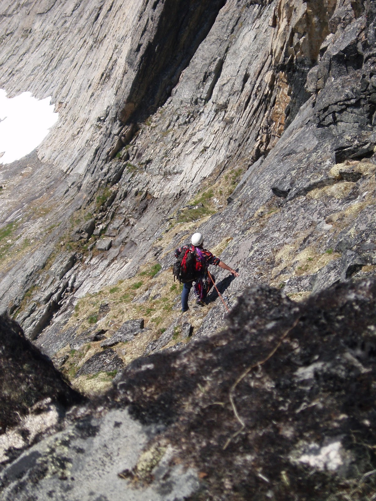
        (above) Phil Westcott on descent of "East Tig", June 2, 2012 ( 5 Saturdays Ago). Much of the route is visible beyond Phil.  The route follows a ramp system perched rather flutteringly over the impressive swoop of the north face of Tigaraha.  A 35 ft. chimney on the summit pitch is visible in the photo as a vertical black line rising out of a notch at the righthand edge of the photo.  In front of that is a rather exposed 5.4 slab.

  5SA The GLUE OF TOWN lay thick and sticky with the post-schoolyear pile-up of personal responsibilities.  The GLUE threw everything it could think of in my way, including, at the last minute, a failed, moose-blood dripping, refrigerator/freezer in my home.  In my blind frenzy to cut through the GLUE with the MACHETE OF SELFISHNESS to make my escape to the mountains, I committed many uncoolnesses;  wasted meat of moose incurred loss of karma points.  Thanks go out again to life-partner Kristine whose own nonentropy field counterbalances my own considerable disorder, and without whom no Kigsblog would be able to combine action with rave and spew.  
      Part of the urgency of the climbing window at the time 4SA was the dual presence of those two most rare commodities: good weather in the Kigs, and a motivated partner.  Phil Westcott was here for the Spring in the employ of the National Park Service and seemed to have the right set of rather off-beat qualifications to make a proper Kigsboy—  i.e., an individual who might see some sense in doing worthless climbs on small, toppling choss heaps with huge, torturous approaches.  We set the compass to STEELY FOCUS, hacked our way out through dense foliage composed of doubt, schedules, computers, parties, the GLUE, in short, to the mountains, where all was soon forgotten.


(above and left) Tigaraha from north.  The pitches are marked on the E. Tig to give a sense of scale. The best descent is to downclimb the route.   For greater kicks, from the summit of East Tig continue west along the spine of Tigaraha following the 2005 Peacock-McRae route (IV, 5.9)  MARK!, leg up, spin, leg up, can't find it, tail in the way, MARK!, spray some down there, ah, the easement upon the swollen bladder of Narcissus brings relief  the continuation of the East Arete to the Grand Tig, by downclimbing two pitches (these would be the West Ridge of East Tig, 2 pitches, 5. 3), then getting back up on the spine of the arete via an enlivening 5.9 pitch with a rotten overhang-- the rest is a sidewalk in the sky with great climbing up to 5.8 until you reach the summit of the Grand Tigaraha, whereupon downclimbing the 5.3 sky-friction slabs of the West Arete bring you to the West Notch between the Grand and West Tig.  This Notch, accessible by Class 3 slopes, would mark the starting point for the regular route on Grand Tigaraha, the West Arete, (II, 5.4).
    One may return to a basecamp in the Sinuk from the West Notch by heading back east across 4th class slabs that traverse under the 800 ft. south-facing wall Tigaraha, but it's a grovelfest, and treacherous when wet;  somewhat easier to contour around to the northwest of the West Tig, staying high, traversing across Class 3/4 terrain, to the conspicuous "Fab Four Tors," John, Paul, George, and Ringo, which, by the way, are all excellent one-pitch climbing tors little piss here, little piss there, whirl, lift, cancel, whirl, cancel, whirl, lift, little piss here, MARK!.  From the Fab Four Tors one may descend weary lengths of Class 3 talus slopes back to the Sinuk.
        There is a hidden "North Gully" that drops from the West Notch to the north providing potential quick access from the Sinuk to the Grand Tig.  Conditions are usually icy in this chasm, and huge hanging pianos chock the narrow walls.   Once I felt compelled to put in a screw for a self-belay on some weird ice in there;  another time I painfully rappelled North Gully in rock shoes with snow-bollard anchors.  Crampons advised.


(above) 800 ft. north face of East Tig, the Grand Tig in background.  A patchwork spectrum of metamorphized granite.

     Had a discussion this morning with Samuel Johnson on dreaded Facebook (no place for introverts)(link to Sam's blog alpineessence) about a possible climbing metric for assessing approaches;  I don't know if anyone has applied a term to the concept yet, so I would offer: "slog ratio."       
    The equation is stated:

number of miles to get to the base of the actual climbing ÷ 
number of pitches of actual climbing                       =  slog ratio

        For instance, on the East Tig, it takes 8 miles of slogging for 4 pitches of actual climbing, giving a ratio of 8:4, or 2.0—  a slog ratio which, Sammy and I agreed, is horrendously high, bordering on SILLY.  Anything over a slog ratio of 1.0, meaning a mile of slogging for each pitch, would feel silly for most climbers.   Even more damning for the slog ratio of the Tig (and the Kigs in general), an adjustment factor needs to be added to the numerator to account for the last half mile of Class 4 approach slabs, which are steep, loose, and treacherous, more like 4 or 5 miles of effort (with a packsack full of Camalots) than the half mile shown on the map. 
             
(above) Phil Westcott at the rope-up area for the East Tig climb, looking southeast.  Obviously Phil is impeded by his large camera which followers of Kigsblog wish I would carry instead of the paper cameras favored by men of action.  In our later climbings, Phil later had to stow his large camera after it came within one exhalation of rolling off a thousand-foot belay ledge.  
     This spot in the picture is reached from the Sinuk via Class 4 slabs that show a good, healthy "green quotient," meaning the talus is glued down by vegetation for good footing.  One can start slogging west up the hill at a prominent glacial erratic boulder that sits at the Sinuk headwaters;  many bouldering possibilities are available on the way up.  From this spot, one can descend directly west towards the West Notch for an assault on the Grand Tig, but one starts by downclimbing steep Class 4 slabs adjacent to a hideous chasm (Kigsterm for a gully filled with talus) and a rope might be warranted for those sheep unsteady on their hooves.

(below) Ian downclimbing from the East Tig roping-up area, heading west towards the Grand Tig. This image is taken by Mikey Lean from an earlier trip in 2002.
  Norman by that time had turned into a grumpy old mountaineer, regarded by many as sketchy.  Grey-stubble bearded, grumbling to himself, gear in tatters, the dogs of the village barked in protest from their chains.  The younger climbers were friendly, but few would go on a rope with him anymore, except for Jules, who had gone back to the city and his piano... 
     Many come to Nome saying they are climbers, but few keep climbing.   Few lie within the 0.02 percent of climbers who fit within the range of freakish qualifications that would allow them to actually enjoy the climbing on the Seward Peninsula, so they drift away from climbing after a time, with a degree of frostbite usually, and I am left with that familiar feeling of uncertainty as to whether the climbing in the Kigs is really climbing at all, nor daring to look in the mirror at the old mountaineer to gauge the actual degree of his sketchiness.  
      But really, it's the SLOG  RATIO that's causing the climber attrition.  You have to work so hard in the Kigs to get to the actual climbing.  Only a person living in their own fantasy world can continually fool themselves that dragging gear over tussocked ground in the cold and wet with little chance of ever using the gear on a real wall is a worthwhile and noble venture.  Has the global practice of climbing so far degraded as of 2012 that desperate climbers are finding it necessary to hike all the way back in to the back corners of the wilderness for a few stone smudges on a hillside?  What sort of masochist buys into this fantasy?

(below) Phil Westcott and Lucy at the roping-up area, facing south.
     Answer:  Phil.  Phil Westcott of the Westcott Brothers Band showed up in Nome on an SCA internship at Bering Land Bridge and actually sought out the sketch old mountaineer (thanks to flickr and Rick Anderson for the contact, see Phil's excellent photos on flickr), it seemed like a miracle:  here was a young man dropping out of the sky who said he wanted to go climbing the Kigs, had experience on multi-pitch choss from his time at Seneca Rocks in West Virginia, didn't mind a little backpacking, and didn't care a bit that he had no gear.  Furthermore, time would prove him a member of the freakish .02 percent of climbers who actually respond positively to HIGH SLOG RATIO-style mountaineering, even after his toenails fell off and he couldn't really walk for a week or two following.  He has that type of alchemical mind that can take a chunk of anaq (such as the prospect of a horrible slog through Spring posthole-snow with a heavy pack) and transform it into something gold, a mind that crops out unpleasantries, leaving only fun and beauty, so that the mind is tricked into returning again and again to the source of its pain and beauty. 

(above)  View from roping-up area of East Tig, facing southwest.  On the left is a beautiful peak, "Turncorner Mountain" (Pk. 3250+)--   Kristine McRae and I did a horrendous fifth-class schist route on one of the righthand ridges in the summer of 2001.  Lift leg, relax, relax  On the right is a mountain I am fond of calling "Falcon Killer Pk" (Pk. 2840+) due to an attempt on my life by a Peregrine as I was soloing the highest of the granitic tors, visible as a dark bump in the picture, a 5.6 thrillfest with a prodigious drop off the starboard bow.  Lift leg, nothing coming out...ah, there it is, MARK!  I was nowhere near the nest;  she leapt out from behind a granite turret from three feet away in a most murderous and calculated fashion as I was hanging from a hand traverse with no real footholds.  Had I not heard the click of her talons beforehand, I might have let go.
     A necessary skill is managing the GLUE of TOWN, a significant force built into causation that can hoist a trip with its own petard before it's ever left town, a type of causal gravity sucking one back into Nome even as one is trying to leave it. Phil proved he had the necessary focus, achieving escape velocity despite a few swirling, muddy eddies of communal torpor hanging like fog in the NPS Bunkhouse where he'd been staying. We slogged it to Hudson Creek Pass late on a Friday night; it was Solstice, mind you, time of day had become meaningless. Next morning developed sunny and fine, birds chirping, flowers resplendent, brooks babbling, breeze with no bugs. Phil, Lucy and I slogged it some more to the glacial erratic boulder at the Upper Sinuk where we made basecamp and prepared for a steep scramble with gear up the hillside above the erratic. (Better, really, to continue another half mile up the Sinuk valley and curve around into the stunning glacial cirque underneath Tigaraha, then traverse back left across the hillside above the erratic several hundred feet higher.)
(below)  Mylon Schield playing on Sinuk erratic in 2003.


      The thousand feet of fourth class approach can be punctuated by fifth class bouldering.  After hours of sweaty toil, the three of us reached the ridgecrest.  A convenient roping-up area presented itself, also, the STAY!-command spot for Lucy.  The route follows a ramp-system with a few steep spots that leads out over the north face of Tigaraha.  I have free-soloed it several times;  the East Arete of the East Tig lends itself well to this type of Norman Clyde-style approach for anyone with decent climbing skills.  Phil was simultaneously cowed and bewitched—  "I don't think we're at Seneca Rocks anymore"— before getting his sea-legs.  
      I banged in an angle piton at a belay for the simple joy of hearing the ascending RING! drifting out over the vertical walls.  The summit pitch, a 5.6 squeeze behind 3 Volkswagons, radiated the usual Kigs feeling of fun climbing mixed with loose death.    Soon we were astride the excellent pinnacle of the East Tig looking for hundreds of miles from the Singtook in the West to Kayuqtuq in the East down the spine of a sweet little mini-Brooks Range.  I glanced at Phil's eyes;  he was bitten.  Infected.  Smitten.  He was a Kigsboy now.
(above) Phil on top of the East Tig, Mt. Osborn in the background.


(above) Grand Tig from southeast, taken from roping-up area of East Tig.  The 2005 Peacock-McRae route (IV, 5.9) on the East Arete is marked.  The best way to approach the start of the little red line there is top climb up and over the East Tig route described in this post.  The 5.9 crux would be that first vertical part of the red line that regains the crest of the arete.  From here, two easy and utterly-spectacular pitches follow the "sidewalk in the sky," followed by two pitches on the headwall with a 5.7 jamcrack to the summit.  Descend the 5.3 slabs of the West Arete and rappel a 5.6 overhang to the West Notch between Grand Tig and West Tig.

(above) Ian nearing the 5.9 overhang that gains the East Arete of the Grand Tig;  photo by Mikey Lean from an early attempt in 2002.
(above) "Chimneys of Tiresias," (III, 5.8, A1), on Northeast Wall of Grand Tigaraha.  Soloed in June, 2007. Four pitches up the north face to where it joins the peak's "regular route," the West Arete (II, 5.6), then three more classic, easy, and spectacular pitches up low-angle friction slabs to the summit. This is the only shot I seem to have of the West Arete of Tigaraha.  There is a deathly chockstone on Pitch 4 of the Tiresias Chimneys that necessitated a point of aid so as not to brush it with the slightest touch.
(above) Map of Tigaraha area 1) Park at incut gravel pit on west side of Kougarak Road around Mile 29.  The first quarter mile of bushwacking is the worst part of the hike.  2) Sinuk basecamp  3) Tigaraha  4)  Hundred year-old rockfall across Windy Creek-  best camp in the Kigs.  5) Mosquito Pass  6)  Pt. 3207, high point of "False Tigaraha"  7)  Grand Central Valley  8) "False Tigaraha", mismarked on maps as the real Tigaraha  "other 8")  "Hudson Pass"

Friday, November 4, 2011

Supertramp Buttresses Revisited

(above)  MagicBus of the Seward Peninsula visible from Teller Road around Mile 29.  It belonged to a miner in the fifties.  Geiger counters have clicked on the bluff nearby.  

     Every wilderness area in Alaska should have a bus.  A good old, transit-style, schoolbus.  There's something about the parabolic configuration of a bus placed upon barren tundra which focuses the SINH TALA constantly streaming through the Earth's pores like solar wind, causing an ever-so-slight time distortion within the walls of the bus.
(above) Kirk, Spock, security team, and Lazarus, ill-fated time-traveller, just prior to another cosmic energy wink— a rip in the fabric of space/time is about to occur within the walls of Lazarus' spaceship—  "Arctic Tundra Magic Bus Phenomenon" is not unlike the time-distortion event depicted in the The Alternative Factor, though without dilithium crystals, the effect is greatly diluted.


      It is never a good idea to sleep inside such buses.  If the wilderness-traveler spends TOO LONG within the bus, a desynchronization between mind and society ("society" in this context being synonomous for the purposes of this blog with "GLUE of TOWN") occurs.  The ensuing schismogenesis of awareness can be injurious to the mental health of the wilderness traveller, as in the famous case of Alexander Supertramp in the MagicBus over by Healy. 


(above) Alexander Supertramp in front of Bus 142.  A victim of Arctic Tundra Magic Bus Phenomenon.  Like Lazarus, his doppelganger traveled from a parallel dimension through the time portal of the bus, cancelling out his life force.  This is a possibility overlooked by Krakauer.

       Visionary, or idiot?  
magicbus1       magicbus2       magicbus3     directions to the      
          magicbus 
       In 1992, my friend Jeff spent a night at fifty below in that bus on Stampede Road, nine months previous to the Supertramp episode. He had committed the rookie boge of thinking that the bus, with all its connotations of urban homeostatic control, would provide a warmer bivvy than his own tent.  I was in Fairbanks that same night;  the cold metal of the bus transmitted live images across the Interior through the crackling air to my dreams showing my friend Jeff hovering like a reverse-fetus on the cusp of between life and death.  But the coming years would prove Jeff difficult to freeze.  Visionary, or idiot?   If Lazarus crept up on Jeff that night in the bus, I have no doubt he, like Captain Kirk, wrestled his insane counterpart back into the other dimension, a 5.10 move Chris was unable to onsight.   I still believe the emergent Fairbanks hardman skirted the same MagicBus Death Attractor that would eventually fell Alexander Supertramp.   


   (above) The MagicBoat at Grub Gulch, Goldbottom Creek, Old Glacier Creek Road.  Incongruity with landscape seems to be a causative factor in Arctic Tundra Magic Bus Phenomenon.  This boat may pose a potential trans-temporal rift.


Great loops of thought
Huge tangles of confusion
Dense thickets of epistemology
Fogs of unified awareness
A victim of my own tribe
They'll never find me here


(above) The white patches below the pin are two patches of chossorific marble, visible on the hillside from the Sinuk River Bridge though one can seldom discern whether they are cliffs, or just steep patches of barren bluff.  They are, in fact, 80 ft. cliffs, though the choss factor lies over the threshold for any kind of safe climbing, these cliffs ooze instability like a victim of Seasonal Affective Disorder. The blue line marks an intermittent 4-wheel trail that leads from the MagicBus at Mile 29 Teller Road all the way in to Glacial Lake. (The pink line shows where Andy and I joined the trail after hiking around Glacial Lake;  I wouldn't advise that.) The Supertramp Buttresses lie three or four miles down the trail.  More recommendable is the schistizoid bouldering pile that lies just to the west.
(above) The 60 ft. friction slab, the only redeeming feature at these structures that I call, for some reason, "buttresses.  Maybe the way they are built into the bluff like a sod house and seem to buttress up the hillside;  also the reason why setting up a top-rope anchor at the top of these cliffs would require a network of rebar anchors sledged into the hillside, a technique I've not yet tried.  This is the most crumbly hideous marble you ever saw in your life.  However, the particular patch of slab shown in the photo above provides a touch of decent rock, with bail-out ledges onto merciful tundra at all times.


     21SA- 


      For pure southside Kigswater, there is no drainage like the Sinuk.  Is the Sinuk not the holy Ganges of Qaweraq?  Huge rivulets of power course down this central hallway from Tigaraha to the sea.  
       Of course, the mystical Two-Six was strange-attracted to the micro-region shortly after his arrival on the Peninsula, so I found myself hiking in to the bus with him one early Summer day, with huge patches of snow aiding our progress along the top of the Sinuk bluff.  Tricorder readings showed no paranormal activity around the bus, so we continued north down the bluff for several miles to the rocks, where Two-Six had hesitantly agreed to belay me on marble top-ropes, my third attempt to do so at this location. 
          But first, some warming-up on the schistozoid Tertiary meta-sedimentary.
(above) Schist outcrops by the side of trail. You branch off to the right (northeast) from here and contour around the hillside to get to the absolutely-worthless Alexander Supertramp buttresses.
(above and below) Srik-Srik. An odd sort of flake-pulling Gaston was required to pull the lip.  These pictures are from a Fall of 2009 bouldering trip in the Supertramp schist gardens. 
(above and below)  Collins controlling the swing on Srik-Srik.  We carried climbing shoes that day, but never put them on.
(above) Iglaaq (Stranger), 21SA.  The Aaron Ralston potential is high right there.
(above) Collins on Kiiraq (Corrugated), 2009.


        The Supertramp schist is passably fine, the stuff of which dreamlike, wandering boulder sessions are made.  The marble, on the other hand, is so bad that I could not devise a safe-enough belaying scenario to which Two-Six could be fairly subjected.  This stone radiates paranoia;  fractured, multi-ton columns sit poised on ledges, balanced on skinny pedestals.  Patches of Grapefruit-quality limestone intrude, but at the Supertramp Buttresses these quality patches don't seem to link up in meaningful ways.  Anchors were virtually non-existent at the top of the cliff;  not even a bolt would do, being as the rock is only layers of flakes, like stacked shingles.   Only a hardened, helmeted choss-junky should be allowed to belay under a pile of anaq this bad.  Two-Six did not fit the bill;  he is too valuable a personnel to be so wantonly crushed.  He dozed in the sun while I climbed around, jeopardizing my life as hard as I dared on the friable rock.
(above) Aquila chrysaetos canadensis, August 2009.


       I came out here to the Sinuk bluffs once, alone. I was trapped on the cliffs by a Grizzly herd, my shotgun far away. Trying not to freak, I was scrambling breathlessly like Ralph at the end of Lord of the Flies, when, BANG!  I turned a corner and ran smack into a family of Golden Eagles.  I thought they were turkeys at first hopping around on the tundra.  


Saturday, August 20, 2011

Third Tog, North Ridge, Slimedog Millionaire

I'm fixing a hole where the rain gets in...

(above)  "Third Tog" (Pk. 3150+), Crater Creek valley.  North Ridge is the righthand skyline.

     1SA (1 Sunday ago)
     Andy Sterns and I slogged to Crater Creek for another attempt on the North Ridge of the "Third Tog".   Boy, did we get Murphied:  the days we were in the mountains, it rained, and the days we were out of the mountains, the sun shone, and shines still, as the GLUE OF TOWN holds me fast like a clam-digger with one boot stuck in the mud of Turnagain with the tide coming in.  M.L.D.'s-- Murphy's Law derivatives--  always difficult pills to swallow. One endures the irony-burn of all the oh what a nice day!s with as much good cheer as one can muster.  
      Though no SEND was obtained, we did some great pitches of sliming, despite the climb.  Andy was a driving force in comparison with my natural laziness and exuded immense climbing drive every morning.   Where my other Fairbanks friends poke fun at the choss topples in the Kigluaiks, Andy hallucinates routes are there.  We pretended to establish a partial route on the biggest of the Togs, "Slimedog Millionaire," two pitches of ICKY super-slime over fairly nice rock at S-8 ("slime-eight") with a few "Scottish-free" moves.   

(above)  North side of Tog 3, Crater Creek.  To see the approximate climbing line, you could click here. For an account of my rained-out solo attempt on the Tog last year (which I have foolishly reiterated this year), plus a discussion of Crater Creek hiking, you could click here.  The rock is granitic gneiss.

       On last week's attempt, Andy and I got about a third of the way up the ridge before severe SLIME necessitated a quick rappel back to the safety of the green slabs at the base, where Lucy the mountain dog was waiting for us, scampering on fourth class terrain.  
       The whole route, we learned, is probably only four pitches.  On many earlier trips to the mountain, my brain had perceived the Third Tog as a soaring Temple Crag fluted with multiple Moon Goddess Aretes, and had thusly persuaded Andy to "drain his tank" of mileage and come climbing in the Kigs. What we found there was more like a highly-degraded Aeolian Butte-- but what a gorgeous middle-of-nowhere in which to be climbing! 


(above)  The "human mules":  Rick, Daniel, and Andy, with Lucy, pausing at glacial erratic, Crater Creek.  Did I mention we were cold?  Yes, assuredly so, everyone is soaking wet.  A breeze is blowing.  Alaaparut.

       For the first time ever, we experimented with usage of human mules.  The idea was to exploit unwitting locals by offering them a few pittances in exchange for carrying our prodigious kit to the base of the moraines.   Rick and Daniel Anderson were easily gulled into leaving for Crater Creek immediately with 50 lb. packs on their backs, despite the rain;  both father and son, I assured Andy beforehand, were "monster hikers," and they certainly proved true my claim.  The idea was that mules would be cheaper than a helicopter with Bering Air, though the final result was mixed;  we grew emotionally attached to our mules, and felt horrible to see them suffer in the wet brush on the way in, and strange about trying to make it a hired gig... yet, did the mules seem to enjoy their burdensome task?  Next year, we'll all ride the helicopter, mule-brothers, how about it?  Yee-Haw!

(above)  Pitch 1, "Slimedog Millionaire."

      The first night was icky and cold;  we awoke soggy-clothed in the morning with the tent in full-puddle.  My ancient, utterly BEAT BIBLER was giving up the ghost, silly plastic pole-guide rings popping right and left, laminations delaminating, pinholes emerging like dripping stars, a ripping noise with every zip.  After so many years of proud service-- stove fires in the Todd-Tex, the massively-rumbling horrors outside the yellow wall, boredom on the inside, novels, pee bottles, drifting snow, pressing my face into the wall all night, spiders, the porcupine I slept with one night--  the tent finally earned its true name on this last trip:  ICKY WOODS.  
       The next day we retrieved the gear that Rick and Daniel had helped us to cache, under pulses of rain-shower and a sky that shifted directions like a candle at a birthday party where all the kids are blowing at once from different directions.  The following day we arose from our icky beds of gelatinous slime and ascended into mist, "just to have a look at the route."  Many crack systems presented themselves;  we chose an attractive one and started up.  Good jams, plugging cams, slimy hands, what does it matter if you got good jams?  But after a few fun moves, a squeeze chimney lubricated with Preparation-H raised a chafing conundrum: "Uh, Andy, I could aid this, but it would be so much more fun if only it were dry.  I just know I would enjoy shoving my body through this painful, corrugated, cheese-shredder, if only it were dry."  Rain was falling.  The black squeeze glistened with Preparation-H.
       So we switched off our northwall brows, and whipped up a top rope, and had an absolute ball climbing in the 100% precipitation for the rest of the day.  We left our gear and returned to Icky Woods.  A patch of sun came out and set us to steaming.  We dried our bags in the sun. Andy proclaimed our fortune had turned, the weather was now good.
(above)  Andy descending Class 4 slabs.  The buttress directly over his head is the proper route;  we chose greener, path-of-least-resistance lines a little further to the right.

       The next day, we went back up into chance of showers, "just to assess the slime-factor," but both of us knew it would probably be our one, big attempt--  we were sodden, and our calories were running out.  Lucy, the Border Collie, on her first technical climbing expedition, proved perfectly cognizant of a dogs role in wall climbing;  at the exact point where the 5th class commenced, she was happy to renounce her until-then constant obssession with following our every body movement, and retreat to the base like a good dog, with no blatant whimperings, nor attempts at mental manipulation at which this one-year old herding-dog excels.   
(above and below)  Pitch 1, "Slimedog Millionaire."

       We decided to damn the aesthetics and just clutch up whatever route would get us through the slime-fields the easiest.  A Class 4 approach pitch on wet grass led to some rock.  I placed an El Cap's worth of gear in about 40 ft., then did a cool little move across a dihedral and belayed.  The pictures show Andy following the cool little move across the dihedral. 
      The dark clouds were engorging, the rain ceiling was coming down fast.  Something happened to me for a moment;  the old tiger came out.  An arrogant Benowitzian impatience took hold;  I sunk all ten fingernails into vertical dirt and spider-clawed up the next 5.7 hanging tundra pitch, without putting in ten-thousand pieces or wailing like an expectant father.  Just as quickly, the tiger subsided back into loserdom and I felt fearful again.  Why the almost angry burst?  It was obvious to me that we would never complete this climb that day, we were soaked, we had no puffy coats, the wind was conjuring hypothermia, and the climbing was slime, only slime.  I felt like returning to Icky Woods immediately and reading about hypothermic Bolsheviks in my book, "The People's Act of Love," by James Meeks.  YET, I knew that Andy, bless his heart, was down there at the belay, perfectly excited to forge upwards into the increasing rain of our decreasing interval, to do one more pitch, just for the "fun" of it. 
          
(above)  The upper pitches of Third Tog, North Ridge.

      I came to a large, ledgy area with a slime-fall coming down from above.  The rain was like a foam, everywhere, over everything.  The upper part of the route looked very doable.  Murphy!  It actually looked like fun, exposed climbing.  This was the point where my woeful misjudgment of the climb became apparent. Hitherto I had held this climb of the Tog as a Jorasses-like north wall where hapless alpinists could potentially end up as frozen barnacles plastered to the headwall by cake-frosting, grimly visible from the green floor of the valley, forever out of reach.  Now I view it is a fun climb on decent choss that one could do in a few hours.  Must get back in there to solo it;  or you!
(above)  Rappelling off Slimedog Millionaire in the rain.  Pitch 1 went where the rope is.

(below)  Andy Sterns in the wet.  Slime factor 7.  Retreat.  As always, Andy is radiating positive vibrations, even though he appears in this shot to be glowering.


        Down at Icky Woods, Andy tuned a weather report on KNOM.  "There is a 100% chance of rain today, 100% tonight, 100% tomorrow."  Powerbar wrappers mucilaginously clung to the tent walls, which shook and spattered with wind and rain.  Lucy curled stoically outside in a nest of mud, too young to ever have known the precedent of coming inside Icky Woods. We discussed our options.  We had brought our gear down from the wall.  The GLUE OF TOWN was oozing in through the cracks in our steely focus.  We discussed relationships and what assholes we were. 
       In the end, it was decided that a full return to town was way too hideous a prospect:  responsibilities and commitments would be waiting there to spring like hidden predators.  We settled on the idea of hiking out to Earp's cabin the following morning with half the gear;  we would hike a "Togathon" the following day, in and out of Crater Creek, sixteen miles, to retrieve the rest of the gear.

(above)  Andy wading Crater Creek on our exodus, Thursday, August 11, 2011.  Still a casual crossing, but I had never seen the water that high.

       Here is what my friend Diana Haecker wrote in the Nome Nugget, week of August 18, about the day that Andy and I chose to flee Icky Woods and the mountains:

                         The unusually heavy downpour of rain last week made Thursday, August 11,
                         the wettest day in almost seven years with a precipitation of 1.21 inches, reports
                         the National Weather Service.  This is in line with the trend of this wet summer
                         of 2011, which already saw July being the seventh all-time wettest month in
                         Nome's 105 years of weather data record keeping.

It sucked.

       Crater Creek had physically increased in length.  We suffered.  Allapa.  We reached the 4-wheeler.  The plan was for Lucy to run alongside the 4-wheeler for several miles;  "I'll just perch up there on top of those bags," her eyes seemed to say, so we let her on.   The Clampetts motored down the Kougarak Road towards the dry cabin. 


(above)  Salmon Lake

             Earp's cabin had never felt so good.  I'll never forget the smile of the dog, who had been sleeping out in the drink for days.  But like an invisible gas, the GLUE OF TOWN seeped into the room.  A phenomenon known as "Relationship Force" was exerting a strong current on Andy, as he had not seen his partner all summer.  That meant we were hosed;  I myself am tragically predisposed to succumb to the GLUE.  It became a foregone conclusion:  the next day, our party of three piled onto Prolly, the 4-wheeler, and motored back to the fleshpots of Nome.

(above)  Tog 3 in Winter.

        The "Togs" is my pet name for the metamorphic-granite structures that one encounters in the south fork of Crater Creek.  These cliffs are not visible from the Kougarak Road, but unfold spectacularly when one turns the corner on the obviously-glaciated valley about six miles up.  The name derives from a color-coded designation in the explanation of my geological map of the Kigs, "Bedrock Geologic Map of the Kigluaik Mountains...," by Amato and Miller.  The good climbing rock in the Kigs shows up as pink on this map, and the explanation reads:  "pre-Cambrian Thompson Creek OrthGneiss," from which "C-TOG" was derived, which Andy and shortened this trip to simply TOG.
         I identify 7 separate Togs in the valley.  This is a cusp area where the pluton is in contact with the schist;  Crater Glacier must have come through during the last glaciation and sliced off the very edge of this plutonic uplift, leaving little fingernail clippings of granitic gneiss lying upright on the southeast wall of the valley.  There's plenty of rock up there.  The 7th Tog (Pk. 3950+?) is one of the highest peaks in the region;  got to get out of this naming business, really, the true EarthSea names of things are locked inside the land.    The Third is the largest of the Togs;  the summit is pleasantly attainable on the Class 2 south side;  try bouldering your way to the top on the northwest side via discontinuous I-can-imagine-it's-granite slabs interspersed with great fat-pad balconies made of hanging tundra.


(below)  Crater Creek area.  This is an old, rather sloppy map.  Regarding the approach to the Togs, the verdict is in:  it's easier to hike on the riverbed on the way in (but more bearonoid).