 |
| Looking up Oregon Creek. Pk. 2900+ in background. Super Smooth Andy G. in foreground. |
 |
| Parts of the old road are still visible and helped us get through the willows to the gulches on snow-machine. Saw no cabins, but lots of remaining ditches on the hillsides |
 The greatest excitement occurred during the snow-machine phase, of course, the most dangerous segment of any trip, when, unbeknownst to my own awareness, I executed the most prodigious jump ever accomplished by myself on my snow-machine (the redoubtable Bearcat, Super Smooth Andy G.) when, purely by accident, I launched off a bare tussock at high speed and sailed 16 feet over a creek. Leonard, following my tracks, wasn't as lucky... his front end went into the creek and he over the handlebars, his face smashed in the process.
"How is my face?" he inquired.
Oh no, the wedding is off. It was like that Seinfeld episode where George drops the guy at the Shawangunks. How is his face?
"Not gushing."
He examined himself in my phone. Nothing to do but get back on the hogs and GUN IT onwards toward our objective.
Did I mention it was cold? Allapa, allapa, yes, cold as a van of I.C.E. Agents throwing up dust in a carrot field. Since I had never climbed Pk. 1900+ (though it has undoubtedly been well walked-over by members of the Oregon Creek mining community who lived at the foot of it some time last century), I left my skis strapped to Super Smooth Andy, and set out to bag the summit. Leonard couldn't go up because he had neglected to bring his Micro-Spikes, and the snow, which could no longer be deemed snow but simply ICE, seemed really a bit treacherous, take-off-like-a-rocket-on-easy-ground kind of thing.
 |
| Shadow selfie on summit. |
"Could this be the mist bootyful somewhat we half ever seen." Just short of a Donald, Pk. 1900+ evinces a pleasing architecture, the ridges like runnels, the kigs-view as encompassing as any hill's, jagged as it is into the big flows of weather that stream across the peninsula between the Norton Sound and Imruq Basin, the very flows that had hardened our ski into an ice climb.
 With the attainment of this high point, all of my dreams and ambitions had been realized. Buddha-hood, achieved. Ego/Id structure, momentarily stabilized. My self-identity was no longer in doubt for I had become nothing. There lay the Kigs in the near distance to the north. The GLUE TENDRILS simply vaporized into wisps that dissipated in the clear, cold air.
  |
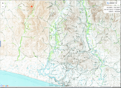
| One looming question remains. Is Pk. 1900+ the intriguing summit that often pokes up behind the Snake River hills as I am driving home on the Beltz Highway from Nome? The one that sometimes gets mistaken for Osborn because of the way it pokes up? In other posts,, I have attributed this peak as Pk. 1460, the one out by Cabin Rock. So I drew this little map to see if there existed a line of sight poking through the Snake River hills. Thinking now that peak must by 1900+. What an utterly exciting discovery to make in a mundane life of driving back and forth from Nome to home. |
