Showing posts with label Seward Peninsula ice climbing. Show all posts

Wednesday, July 13, 2016

Cape Nome Ice, Iteration 2015

Cape Nome ice climbing
In December light, James is climbing quarried chunks of granite held together by frozen mud
Red arrow points to Ayasayuk, Cape Nome. 
Nome ice
Third Tier ice, 2015. We climbed a dirt/ice line out of the picture to the left. James was fated to leave town, the Winter Solstice world grew mega-cold, and the GLUE OF TOWN sealed me over. I never made it back out to climb this pitch.

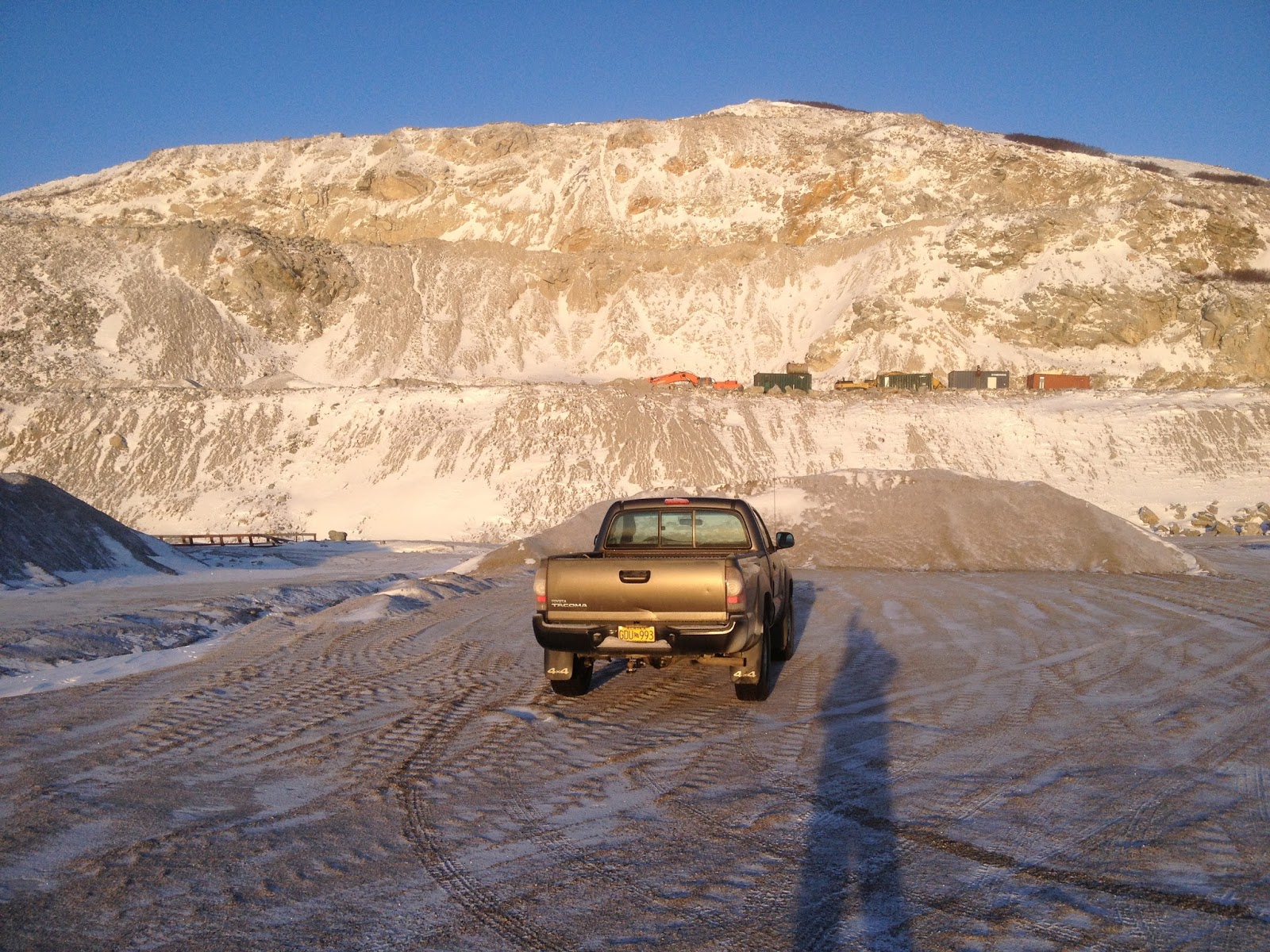
       Cape Nome lies about 20 miles east of Nome. Viewed from Nome on a clear day, the bluff resembles a 5-mile long sausage, with the seaward end of the sausage visibly gnawed-on. Drive out there on the Nome-Council Road and the gnaw-marks prove to be the 450 ft. high Cape Nome Quarry, a long-time source of “industrial grade armor stone and rip-rap commonly used on seawalls, causeways, and breakwaters,” and also, my secret, no-doubt-trespassing, little ice climbing area in the late Fall. 
        So loose, such a hanging mine field of rock and mud is the Cape Nome Quarry, that one would never set foot on it unless it were well frozen. The Quarry is a little microcosm unto itself, a self-contained space shaped not unlike a Greek theatre. The ice that "cryo-sucks" down the face each year is a study in randomness, for no two years are ever the same. Somehow, a central flow always develops, but the path followed by the water varies according to a complex equation involving temperature, saturation, and dynamite.
         We are used to the ephemerality of ice, but this is ephemerality of Earth. Some years the quarry face has been blasted away completely leaving no trace of the climb from the year before. There is something satisfying about doing a climb which has never existed before, and will probably not exist into the next year. This year's iteration of Cape Nome did not offer particularly high-volume ice flows, but it did offer the usual helping of climbing adventure as I managed to once again to ascend the quarry face from bottom to top, up the middle of all four tiers. 
Cape Nome ice climbing
James hiking the First Tier, Council Road below
Cape Nome ice climbing
Ayasayuk, November 2015

       I drove out there twice in late November to check it out. Some interesting pillars of ice had blossomed, but my first order of business was to complete the yearly game of ascending the quarry face from bottom to top. I started up solo, but in the middle of the third tier, the ice receded into the mud wall, leaving me looking at a hundred feet of exposed, frozen mud soloing. All I could think of was how much better this mud section would be if I could go back into town and talk James into coming back out with me to hold a psychological rope.
       So we returned in early December. Technically, it was James' first alpine climb. Too bad his first ice climb had to take such a ghastly form. Stupidly, we double-rode on the snow-machine to get out there, bumping across the tundra, getting lost in the fog, and overheating the machine as people passed us by in their nice comfortable trucks up on the road, which was still open, it turns out. 
       We accessed the magical quarry kingdom from one of the access roads that transverse the face, and then dropped down to the main Council Road to make the full, bottom-to-top ascent. The first two tiers of the face are a casual mud romp, no rope necessary. Frozen mud seems to behave exactly like ice, and crampons and axes work quite well if the saturation is right. In between the tiers, the access roads provide big, spacious ledges.
        The Third Tier is the highest of the four tiers, more than a pitch. The main ice flow could be cascading down on the right in a spot that was different than the year before. A new pillar had formed, and above that, ten-inch thick slab of ice was trying to adhere to an utter hanging shit-pile of creeping granite blocks. I fully intended to return for this ice a later date, with a rack of stubby screws and a James now schooled in the ways of ice climbing, but for now, the line was to take the path of least resistance, up a mud groove to the left with an easy piping of Grade 1 blue ice at the back of it.
       At the spring, the high point of my solo a week earlier where the ice recedes into the mud wall, I made a good belay and brought James up. It's not like the next pitch was hard. There's not a hard move on it. There is just something hideous about steep frozen mud climbing. The medium is like real ice, so you whack your tools extra hard, but you feel like some sort of slump or solifluction is going to suddenly pitch you off and down the 45° slope in a great clattering, clawlike mass of spikes and rope. I drove a few Snargs and Spectres straight into the mud. They wouldn't have held a thing.  I really don't know what James thought of the whole charade as he is always rather an inscrutable lad, but I do know I was overjoyed to have him there holding the useless belay. Hard to say whether that pitch was a Class 4 scramble up some dirt, or a real pitch deserving of an "M" rating. Probably the former....
       The Fourth Tier, only about 60 ft. high, offered more flows and steep ice, but the afternoon light was throbbing with darkness. We did an easy pitch up the middle and reached the top. Waves from the dim sea lapped against the beach hundreds of feet below. An emaciated Red Fox watched us curiously. The December sunset was only a red smudge against the gray pall in the west. The lights of Nome could already be seen, and the GLUE of TOWN began to suck us slowly and inexorably toward it.
Cape Nome
Third Tier from the Proscenium
ice climbing in Nome
Looking down Third Tier
         As we zig-zagged down the access roads in the big, deep, Arctic dusk of December, still wearing crampons because the roads were a sheet of ice, I noticed the hydraulics of the ice flow underfoot. In places, birms made by machinery had caused the ice to pool up and grow thicker. Could it be that water flowing down the access roads is the source of the ice flow at Cape Nome Quarry? I had always assumed that some type of aquifer was leaking out the scar of the blown-out bluff, but this makes little sense given the elevation of Cape Nome and the fact that water does not flow uphill. 
        Geologists do not seem to have come to a consensus regarding the Late Proterozoic meta-granite of Cape Nome. Is Cape Nome related to the meta-igneous gneiss of the Kigluaiks thirty miles to the North? Just what is this anomalous little intrusion of ancient rock doing here?Marine life seems to get bunched up in the waters off the cape. Before the dynamite and the flu epidemic of 1918, plenty of people lived on the bluff. Strange little men called isragak roam the grassy headland. It was named "Ayasayuk" by the natives, "Tolstoi" by Captain Tebenkov, "Sredul" on an 1852 Russian hydrographic chart, and finally, "Nom" by Sir William Kellet, though what the British explorer meant by writing that word on his map is anyone's guess. 
Cape Nome Quarry 2003
The glory days somewhere around 2003 when that Grade 3 ice on the right used to come in. This is almost an entirely different cliff than the one in 2016 (though odd vestiges remain). Begging forgiveness from BSNC... 

Sunday, December 23, 2012

Dorothy Falls

       Analogy for Interior Alaskan ice climbers:
  
Fairbanks, Alaska is to Dragonfly Falls
as 
Nome, Alaska is to Dorothy Falls. 

       The analogy holds, though Dorothy be not half Dragonfly.  Dorothy is where climbers are generally referred when the question is asked: "Is there any ice climbing round Nome?," though what the climber finds after hiking up the wonderful Dorothy Creek is only a paltry, rounded, 20 ft. blob of blue ice, WI 2 at best.
         I had climbed there many a time in the past, but not since the inception of Kigsblog in 2009, when Nate Skains and I spontaneously decided to motor out to mile 24 Kougarak Road on Saturday a week ago.  Since Kigsblog has never posted on the topic of Dorothy Creek, here arises the opportunity to "poo poo" this "popular" ice climbing area, just as a Fairbanks hardman might poo-poo Dragonfly for being the popular destination of weekend noobs, with a parking lot full of cars and young people in shiny new Gore-Tex, when the real climbing lies hidden deeper inside the canyons labyrinths, or up in the highest mountains.


       Nate and I developed exoskeleton as we ran laps up and down.  Dorothy Falls drip-streamed blue and wet, with the temperature well below zero;  water drip-dropped copiously from the surface of the ice as we climbed, then flash-froze onto our creaking Gore-Tex suits.  Our soft, warm bodies became encased inside a hardened, jointed, translucent shell, the memory of our warm-blooded, mammalian selves sealed over by cold, insectile sensibility— with the need for stealth and constant movement to keep from freezing immobile.  I was destined to ride home in Nate's Jeep still wearing my crampons frozen onto my  feet by the exoskeleton. 

       Cleaning out cobwebs in the brain pathways that light up with ice climbing... cobwebs accumulate rapidly while you were away on the rock... Had to rediscover that weight-shift, "monkey hang" thing in the hips where you stick your tushy out into space behind you even though your brain does not wish to stick your tushy out, only then does the absurd little system of opposed spikes on your toes and hands dig in to the ice correctly...   Death-knuckling of the shafts (due to the primordial fear of being surrounded by a steep walls with no purchase or friction whatsoever) gradually began to subside, and it was relearned that you barely have to hold on to the shafts at all.  Soon, I was bored at Dorothy Falls, a good sign...  We soloed many laps, trying to get the feeling back of movement over ice, enjoying the bonus adrenalin rush that comes each time you make the Zone 2 pullover at the top.

       The real fun comes on the mixed highballing problems to the right or left of the icefall that climb over the 20 ft., circular, marble wall that forms the Falls amphitheater:  steep little ramps and corners tufted with frozen dabs of turf necessitating stemming and pull-overs that are not without mental stimulation owing to the consequences of a mistake.  One M-5 move from last Saturday stands in my memory:  frontpoints precisely stemmed out on crystals in a nicely formed corner, you lean out and sink a big fatty in an overhanging, overflowing, overgrowing blob of turf, and without hesitation at 16 ft. you lean  your full weight back on the rig and yard up. 

       Johnson was hungry that Fall.  A man just gets tired of ptarmigan, that's all.  He was stuck out at Dorothy with everything iced up, no early season snow, the days short and dark, Nome looking very far away, and no company at the cabins except for Mr. Wiggins, and wasn't he a barrel of fun?
         One good thing:  the Company had set him up with some fine gear to use that season.  He particularly enjoyed the custom creeper / snowshoe rig he had engineered from all the truck:  right now, in this cold drought of a December, he was only using the creepers.
         After breakfast one morning around Christmas, Johnson went for his walk up the Creek, walking right out on the creek ice which was blue and bulging with suppressed flow.  As usual, he continued all the way up the drainage (which, Johnson had to admit, was not seeing the kind of color they had come to expect from it in years past) until he reached the waterfall, a charmed little spot that just made a hell of a swimming hole on a hot summer day.
       Now, Johnson, as you know a student of Eckenstein, Fehrmann, and Perry-Smith from his time at the Technicum in Saxony, as you might predict had on prior occasions executed a few moves of technical rock-climbing on the limestone walls at the swimming hole.   This Fall he had fashioned sharp and wicked hooks for his hands with a clever harness system, and with the excellent creepers on his feet intended to climb the ice of Dorothy Falls itself.
      But his efforts were over in a few seconds.  Johnson found his hooks and creepers bit the soft, pliable ice almost effortlessly.  A few kicks, and he had surmounted the steep bit in the creek.  Dorothy Falls had not been worth, as they used to say, "leaving the whiskey bar."  Johnson felt a bit embarrassed about his little divertimento--  it had taken him the better part of a day to fashion the gear.  No need to tell anybody about this one....  

       Beta:  find Dorothy Creek on the map, somewhere around Mile 20 something Kougarak Road.   Cross Nome River which is braided in this area, crossing can be problematic but usually not.  Head west up Dorothy Creek drainage at a red cabin visible from road.  Falls is a mile or two up the drainage.  If summertime and bearanoid, walk up on hillside above the drainage to the left (south) and easily drop back down into drainage at Dorothy Falls amphitheatre.  If not bearanoid, enjoy walk up the creek, about anybody can do it.  If creek is frozen, definitely wear crampons, the hike is almost always interesting and really fun and never deep enough to truly drown.  When Nate and I hiked it last Saturday there sure was a ton of overflow building the creek up.  A great place for beginning ice climbers, never hurts to bring a rope and some screws.

Wednesday, October 31, 2012

Pk. 3653, "Little Singatook"

Grand Singatook (Pk. 3870) on the left, Little Singatook (Pk. 3653) on right. The Little Singatook is WEST of the big one.

      Fog was draining the snowy Kigluaik Range like mucus subsiding through sinus passages out towards the sea.  In the bright breathing sunshine left in the fog's wake,  Lucy and I were heading west on the Teller Road bound for the Grand Singtook, Peak 3870, the Mt. Washington of the Seward Peninsula, where hopefully a basting of ice garnished its walls and buttresses.  Time was crystallized that day, Sunday, 1 Saturday Ago,  there was only NOW, beauty wallowed in fields of itself, a total chi-fest echoed down the hallways of eleven-dimensional time/space.

(above) Northwest aspect of Grand Singatook (Pk. 3870) taken from "Singtairuq" (Pk. 3653), Saturday, October 27, 2012.   In June of 2004, Nils Hahn and I climbed this side of 3870 by traversing down on to the face from a point halfway up the lefthand skyline (after drunken June bivouac on eastern slopes);  we finished in one of the Scottish gullies leading through the steep cliff band there at the top for three pitches. 

      The "Singtook" stands at the western bulwark of the Kigluaik Mountains;  it is the cleaver that cleaves the big weather systems flowing in off the Pacific.  Known to locals as "Thirty-Eight Seventy," it rates only a lump in comparison to Chugach or Alaska Range peaks, but nevertheless is a peak invested with psychic energy. 
      Imagine a family back in the day piled high into an Umiaq making what must have been a very worrying crossing from King Island to the mainland:  
          "Daddy— when is it ever going to end?"  
         "Just concentrate on the Singtook, my son, and reel that mountain in."
        Someone from King Island told me they looked for the outline of not one but two Singtook, a Big Singatook and a Small Singatook, which may explain why 3870 appears as Grand Singatook on the map, semantically implying there are other, lesser Singtut in its vicinity—  not to mention the -k ending on "Singatook," possibly indicating the amazing, inupiaq, "duple" plural ending.    
          The Singtook has a little "mini-me" of a mountain standing at its side, Peak 3653, the "Little Singtook" I once heard it called.  Having ascended the Big Singtook various times by various routes with various people in various years (tallying less than 50 percent success rate on this notorious wearer of storm hats), a climb of the Little Singtook—   Pk. 3653 on the map, the Singtairuq—  was now in order.  So that's where Lucy and I were heading in the vaporous heaven of sunshine last Saturday morning.


(above) Teller Road, dissipating fog.

(above) Lucy, 3870.

       Lucy bounded from the truck. Away we went up the gleaming southern slopes of 3870.   The big blue globe of Woolly Lagoon dropped steadily away as Lucy and I made good time over hard frozen snow.  Soon found me donning my creepers to join Lucy's claws, but then taking them off again when granite rock fields intervened, then putting them on once more for good as we sloped onto the icy, frozen upper mountain, where a summit wind sprang up to greet us.
   
 (above) Pk. 3653 from the plateau lying between it and 3870.

    Singtook rose up now on the right as we crossed a plateau.  The recipe of sunshine, mountains, and wilderness had once again conspired to shift the nodal point of my seven chakraed energy body to a slightly different point;  what I experienced in my mind while one-step-at-a-timing it up the mountain was akin to an altered state.  The effect was in the temporal interface:  each moment passed as if through a telescoping lens capable of zooming out to my entire life, and back to the mountain again. 


(above) Summit tors of Pk. 3653.  The tor in the lower picture was judged the higher spire.  Both were ascended by path-of-least-resistance methods with Class 4/5 moves over rimed or snow-covered granite.


(above) Lucy perched on Class 4 summit of Pk. 3653.  SiNtuq in background.  This was actually a rather narrow and exposed summit, for one brief shining moment of real climbing in a life of constant slogging.

     A gift at the summit:  the high point appeared to be at the top of some small tors, meaning the climb might yet transcend the category of mere slog.  Indeed, massive chunks of de-rimed snow were thumping down on top of us, giving the locality a rather Alaska Range feel.  Since the snow bedecking the granite was de-riming, it wasn't much good for pulling on with picks, so I was forced to weave creatively around the tors on ledges, ramps, and blocks, in good Norman Clyde style, in order to access the tippy, tippy tops of both the highest tors.  
       Lucy began to whine and fret, questioning the utility of lingering in such a silly, lifeless place, with the late-October sun sinking fast behind King Island into the molten, burbling sea.
     But once again, human eyes had detected what the dog's keen sense did not—  the gibbous Moon, way over on the opposite end of the Range, already risen over Mt. Osborn.  There would be light aplenty.  Abandon this sense of haste and hurry, though night be falling soon.

(above) Looking east from Pk. 3653 down the spine of the Kigluaiks Range, gibbous moon to the left of Mt. Osborn.

         On the descent, I saw something I will not soon forget. Lucy and I were stumbling along in the gloaming, waiting for the Moon to pop up at our backs so we could see again.  The Moon was taking its time working its way over the horizon of the Singtook.  Meanwhile, the Singtook itself had put on THE MONSTER—  the localized, massive, lenticular cloud which often hangs stuck on the upper half of the mountain or curvi-formed in the air just above.  All mountains have lenticulars, but the Singtook runs a doozy;  it is no place to be.  Many is the expedition that has battled its way up through reasonable winds to the 2500 ft. level on the Singtook, only to encounter there a living, moaning, hurricane-force WIND CLOUD which completely precludes a summit attempt.  
        The Singtook was wearing its cloud, and the Moon rose directly behind it.   White light flared off the mountain, resembling aurora more than smoke.  Beams as bright as a spotlight, then with a sheet thrown over it, then bright again, blackened in the denser patches with sunspots, spasms of light streaming, flashing out, hallucinating.  The Singtook steamed in the night, it was a giant mound of dry ice in a black light Halloween display.  An equal display still smoldered in the west, oranges and reds melting down over Russia. 
       Such beauty gets into you, stays with you for a long time.  I still can't believe what a gorgeous day last Saturday was.  It makes me sad, life can be that beautiful, even for a day.  I must endeavor to serve others well, in exchange for having been given this unbelievable gift.  And thanks to the mountain for offering itself. 


(above) Map of climbing routes around Pk. 3870, Teller Road.
A. Pk. 3653, "Singtairuq"
B. Pk. 3870, Grand Singatook
C. "Eldorado Creek Buttress"

     The red line indicates my route up Pk. 3653 last Saturday.  Along the way you pass near a bluff, "Eldorado Creek Buttress," which sometimes sports a two or three pitch ice climb.  I stumbled upon this bluff lost in a whiteout one time;  since visited with a number of partners over the years, finding a paltry variety of ice conditions. It ain't Valdez— but it does provide relatively quick access from the road to a north-facing cirque in the Kigs near the 2000 ft. level, where ice can sometimes be found during Fall time of year.
      The yellow line indicates the "Solar Sidewalk," the regular route up 3870, which passes by a high lake for swimming in the summer, and which makes a CLASSIC car-to-summit-and-back ski in the late Spring.
      The green line shows approximately where Nils and I climbed the North Face of the Singtook (III, WI2) in June, 2004.

Monday, December 20, 2010

Thanksgiving Ice 2010

  A big freezing rain storm came, Thanksgiving 2010.  Like Christo coating plastic wrap over everything, the QAWERAQ Peninsula was coated with several centimeters of clear, water ice, trowelled smooth by the usual horrendous wind combined with freezing cusps.   Like a town emerging up through the surface of a skating rink, the two-dimensional plane of ice conforming skin-tightly to the three-dimensional surfaces...   Schools shut down in Fairbanks, Anchorage, Seattle...  No snow day here in Nome— at recess the kids launched huge standing glissades across the Zambonied playground.  Routine hikes on the hillsides had morphed into Grade I alpine climbs.  And the rocks!... 

.
(above)  King Mt. rocks, Sunday after Thanksgiving. The shellac was back!  Holds frontpoints surprisingly well.  Man, this is some tasty climbing, what better way to spend a Sunday than to cling to odd facets and angles of these metamorphics, basted with translucent climbing sauce and topped with snow whipped into a crusty froth.  Little cracks and pockets stuffed with an extra centimeter or two of ice are especially crunchy.  Now it's time to hang all your weight from one arm!

(right)  Weak November light on King Mt.  For every route I have topped, I have chickened out on four others.  Frontpoints routinely explode from the verglas with great scrapings of metal.  Four millimeters of the icy film bonded to the rock seems to be enough to support a front point or hooked tool, but the charm of climbing this film, stretched as it is beautifully over a bare face, quickly runs out when you are any distance above the landing, with tib/fib snapping devices strapped to your legs.  As usual, the only tool placement you can really trust is a good solid thwack into a turf patch.

Hook picks or prosthetics.  Torque the crack or broken back.  Concentrate or frontpoint skate.  Climb ice or Spot Device.  
(above)  Mud mounding action from early Spring 2010.     The "mud mounds" are tailings piles left over from gold mining, dirt piles that freeze at certain humidities into the consistency of ice.  They are worked over by gold miners with heavy machinery in the summertime, (all the more in 2010 due to the rising price of gold) become saturated by Fall rains, and freeze into icy dunes suitable for a blunt, barbaric form of ice climbing... and probably a toxic one as well.   
(above) Tailings. Once again, this image is from a previous season, Spring of '09, and it is relevant to note that the dirt in this picture has been worked and reworked since then, so that the mounds in the picture are somewhat different than this year's mounds (of which I have no picture;  the camera has been phasing out lately.) 

(below)  Chipped tooth in the Mounds.  

    It is perfectly possible to get one's "climbing ya-ya's" on tailings in winter.  Out back of where I used to live in the legendary encampments on Happy Road in Fairbanks, an old mining pit was carved into the hillside of Ester Dome, and many a hippy friend was lured from the party up to the forested hillside to try mud climbing in a moonlit amphitheatre.  When I got to Nome, it was like one vast mining pit, and I remembered the fun we had had on the tailings at Happy Road.  Mud mounding is seldom without highballing: one never knows whether the impending fall will bring a harmless roll down steep mud, or a bone-splintering snaggy snapfest.  The fine tailings are better;  sparks fly from your tools when the tailings are coarse.  
     The mud mound's beauty lies in their transience.  Like ice, the climbs are temporary, soon to be demolished by machines and resurrected in the form of new moufile:///Users/imcrae/Desktop/IMG_0668.JPGnds.  I've been motoring out to the mounds frequently this month, in the thin crack of daylight between the end of work and sunset.  Glazed and gleaming ever so faintly with the Thanksgiving shellac, the mounds lead inward to darkness like a corner of the desert. More on Mud Mounds   
(above)  The ice climbs at Ayasayuk in the early 2000s.  Climbed with various partners over the years, and probably been climbed by others (Paul LaBolle among them)...   These climbs have been blown to bits and are gone now...  the pillar in the middle was a steep III or IV.  Link to previous post on Ayasayuk

AYASAYUK is a secret spot out on the Norton Sound coast where great forces of nature clash together to shape the environment.  There were giants in those days.  A high running bluff with bedrock at its base terminates by the oceanside at Cape Nome, where the bluff has been blasted away in increments, leaving an impressive granitic face that grows higher every year.  I never dare touch the poised tripwire-laden rubble pile until it is frozen up.  Those guys that chew it out during the summer are bad-ass.

(Below) Ayasayuk, Saturday after Thanksgiving, 2010.  
This year I kept getting shunted over to the left onto easier mud slopes.  Often felt a vague sense of unease, probably due to looseness.  Had a couple good direct pitches between several of the many roads, and several smatterings of wet water ice here and there. This is my Fifth Iteration of the cliff in my eleven years in Nome.  Here are some pictures of earlier iterations.

(below) Last winter, December 2008.  

(below)  Somewhere around 2003.
Those were the days of fat ice.  Before the giant came with his ANAUTAQ and chopped it all away.  The Earth here has been battered;  I'll bet the Earth was happy to find its new home in Shishamareff and Teller.  All the preceding pictures were taken from the same spot on the Council Road;  you can see the cliff growing bigger.
(above)  Cliff detail, Ayasayuk, 2010.  If you look very closely you can discern a few blobs of ice.  It felt good to sink a pick in real, blue ice.  Man, the lengths you gotta go just to get a little.
(above)  Teller Road, Snake River bridge, December 2010.  Christo also wrapped the roads for Thanksgiving.  Even men with serious trucks expressed their trepidation.  There was surely good ice in the Kigluaiks, but I just kept wussing out on the drive.  One Sunday afternoon I went to the Sunset Rocks but walked the Teller Road from the Snake River to get to the rocks.  The TINGMIURAQ on top of the sign had warned me not to drive any further.

       People sometimes think that climbing ends with summer, or that climbing is only possible through organized efforts involving gear and ropes.  But any thing, big or small, has routes on it.  The chair where you are sitting has some good climbs on it, probably.  Hence, climbing is always happening, at any time, at least to those of a bouldering mentality.
        When everything is wrapped in cellophane, then everything becomes cellophane climbing.  My tally for the Thanksgiving ice:  5 quick trips to the Mud Mounds, 3 trips up Anvil Mt. a trip to the Windmill boulders, a trip to Cape Nome, a trip to King Mt., a trip to the Sunset Rocks, and lots of trips without quite falling down.  Climbing up and down obscure little circuits on moss and verglas, a little bit up here, a little bit down there, monkey hang off some turf, stretch the sacrum, go for it, hook the top, feeling fine....  
        Routes were done.  I am reporting them.  Let them now be worked by backhoe and explosive, front loader and sluicebox, until they are blasted away completely.  It is Solstice now and a fine blizzard has buried the shellac under sastrugi curdles and whipped dollops.  It is not comforting to know that the shellac will be down there all winter, under the snowpack, at the base of all things, waiting....